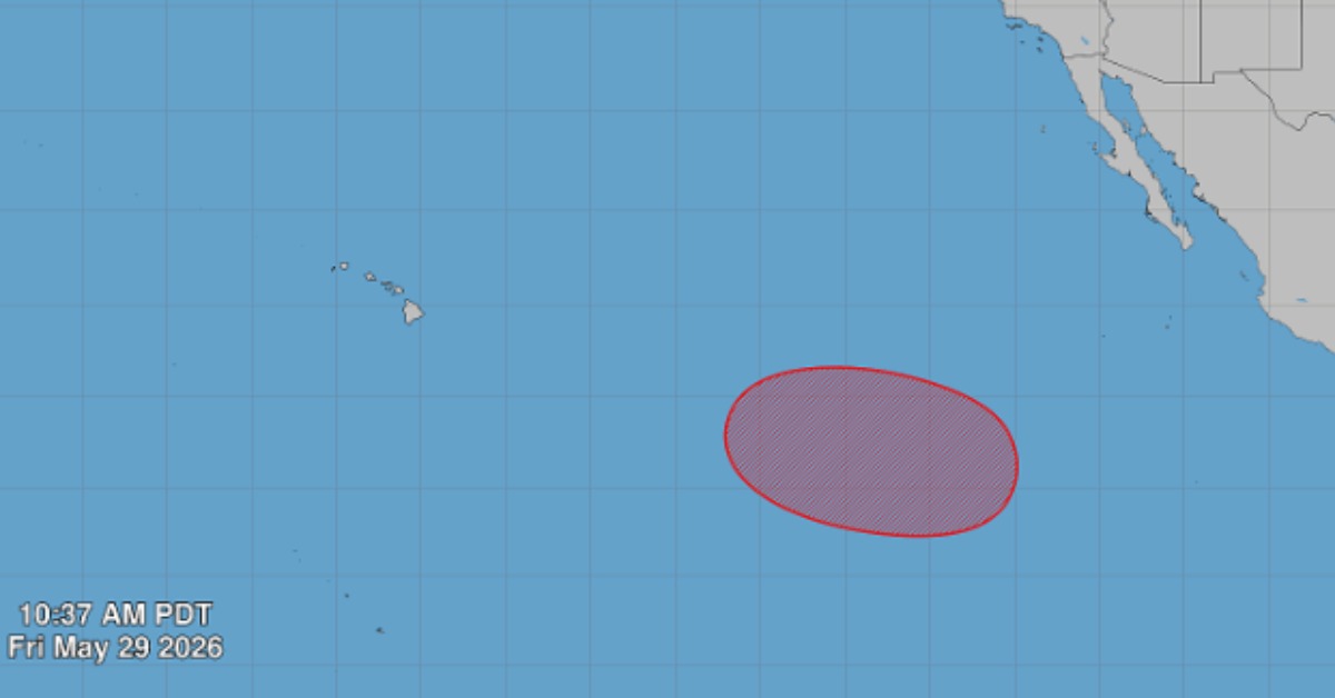
The first name on the 2026 Eastern Pacific list is waiting, but Amanda is not a storm yet. Forecasters are watching a broad low expected to form well southwest of Baja California next week, where conditions could support slow organization. The latest outlook raises the odds, while keeping the immediate forecast quiet. For Mexico’s Pacific coast, the warning is less about panic and more about timing, surf, rain bands, and the limits of early-season forecasts.
Pacific watch rises, but Amanda has not formed
The first serious tropical-cyclone watch of Mexico’s 2026 Pacific season strengthened Friday, as forecasters raised the seven-day chance of development for a system expected to form well southwest of Baja California.
The latest Eastern Pacific Tropical Weather Outlook from the U.S. National Hurricane Center placed the chance of formation at 70 percent within seven days, up from earlier references to 60 percent on Friday morning. The same outlook kept the 48-hour chance near 0 percent, meaning immediate development is not expected.
No tropical cyclone was active in the Eastern Pacific at the time of the 11 a.m. PDT advisory. Amanda is not yet a storm, and no official forecast shows a named cyclone near Puerto Vallarta, Jalisco, or Nayarit.
The official forecast said, “A broad area of low pressure is forecast to form early next week.” It added that “a tropical depression is likely to form during the middle part of next week.”
Where the system is expected to go
Forecasters place the expected area of formation well southwest of the southern tip of the Baja California Peninsula. If the system organizes, it is expected to move west or west-northwest at 10 to 15 mph (roughly 16 to 24 km/h) across the western part of the Eastern Pacific.
That early track keeps the developing area far from mainland Mexico in the current outlook. It also limits what can be said with confidence. At this stage, the official forecast points to possible formation over open water, not a direct coastal threat.
Still, early Pacific systems can change as they organize. Forecast confidence usually improves after a closed circulation forms, and satellite data show whether thunderstorms are becoming better aligned around a center. Until then, the risk is watched through probabilities, not storm-track maps.
Amanda is the name waiting on the list
If the system strengthens into a named tropical storm, it would become Amanda, the first name on the official 2026 Eastern North Pacific list. The names that follow are Boris, Cristina, Douglas, Elida, and Fausto.
A tropical storm is not the same as a tropical depression. NOAA classifies a tropical depression as having sustained winds of 38 mph, or 62 km/h, or less. A tropical storm has sustained winds from 39 to 73 mph, or 63 to 118 km/h.
That means a depression could form next week without immediately becoming Amanda. The name would come only if the system reaches tropical-storm strength.
A busy Pacific season is already forecast
The watch comes two weeks after the official start of the Eastern Pacific hurricane season, which runs from May 15 through November 30.
NOAA’s seasonal outlook calls for an above-normal Eastern Pacific hurricane season, with a 70 percent chance of above-normal activity. The outlook projects 15 to 22 named storms, 9 to 14 hurricanes, and 5 to 9 major hurricanes in the basin.
Mexico’s federal water authority has also projected an active Pacific season, with 18 to 21 tropical cyclones expected in the basin, including 9 or 10 tropical storms.
Seasonal forecasts do not predict where storms will hit. NOAA warns that the outlook is not a landfall forecast and says, “It only takes one hurricane or tropical storm to cause a disaster.”
What Puerto Vallarta should watch now
Puerto Vallarta’s current concern is not a forecast landfall. The system is still a forecast disturbance, and the official track language points westward over the Pacific.
The local issue is readiness in case the pattern later changes. Heavy rain, runoff from the mountains, rough seas, flooded streets, and landslide-prone areas can become problems even when a storm center stays offshore.
Puerto Vallarta had already begun seasonal preparations before this system appeared, including installing its municipal Civil Protection storm council ahead of the rainy season. Local planning is focused on shelters, evacuation routes, flooding, landslides, and high surf.
The next official updates will determine whether the low remains a distant ocean system, becomes a tropical depression, or strengthens enough to receive the name Amanda.
You can track the Pacific Hurricane Season 2026 on PVDN.