The Pacific hurricane season is no longer a quiet line on the calendar. Forecasters are now watching two areas that could become the first organized systems of 2026, though neither is a named storm yet. One disturbance is far from Mexico’s coast. The other could form south of southern Mexico later in the week. For Puerto Vallarta, the immediate concern is less about a direct hit and more about how quickly early-season forecasts can change.
Pacific forecasters are now watching two systems
The 2026 Pacific hurricane season has produced its first serious watch areas, with forecasters tracking two systems that could develop over the next week. Neither is a tropical depression nor a named storm yet.
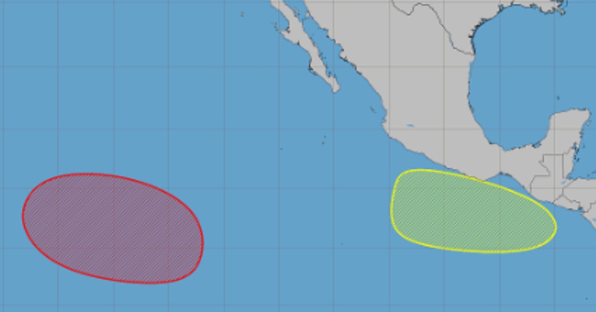
The more likely system is expected to form well southwest of the southern tip of Baja California. The National Hurricane Center said in its latest Tropical Weather Outlook that a broad low-pressure area should form over the next few days, with conditions favorable for further development afterward.
The agency gives that system a near-zero chance of forming over the next 48 hours, but an 80 percent chance of becoming a tropical depression within 7 days. It is expected to move west or west-northwest at 10 to 15 mph over the western part of the East Pacific.
That track keeps the main concern away from Mexico’s immediate coastline for now. It also means the system may become the season’s first tropical depression without creating a direct coastal alert.
A second area is being watched farther east. The outlook says another low-pressure area could form late this week or early next week south of Mexico’s southern coast. Conditions appear favorable for some development as it moves west to west-northwest at around 10 mph. Forecasters give that system a near-zero chance of forming within 48 hours and a 20 percent chance within seven days.
The distinction matters. A watch area is not a storm. A low-pressure area is not automatically a cyclone. A system would need more organization before it becomes a tropical depression. It would need stronger, sustained winds before it receives a name.
If the first system reaches tropical storm strength, the first name on the 2026 Eastern Pacific list is Amanda. The second would be Boris, according to the National Hurricane Center’s storm name list.
No coastal warning yet
There are no tropical storm or hurricane watches associated with either system as of the latest outlook. The higher-probability system is forecast to develop far offshore. The lower-probability system is still only a possible low.
That does not make the early-season shift meaningless. It shows that the basin is beginning to organize after the official May 15 start of the Eastern Pacific season.
NOAA’s seasonal outlook had already pointed to an active year. Its 2026 Eastern Pacific Hurricane Season Outlook gives a 70 percent chance of above-normal activity, with 15 to 22 named storms, 9 to 14 hurricanes, and 5 to 9 major hurricanes expected across the basin.
NOAA also cautions that seasonal forecasts do not predict landfalls for any specific place. The agency states that “it only takes one hurricane or tropical storm to cause a disaster,” even in seasons with lower overall activity.
For Puerto Vallarta, the first monitored systems may avoid Jalisco. But the city is entering a season in which rain, runoff, rough seas, port restrictions, and beach conditions can change before a storm center appears nearby.
Puerto Vallarta has already moved into seasonal preparation. The city established its Civil Protection council before the rains, a step covered in earlier local storm-preparation coverage. The council is meant to coordinate shelters, evacuation routes, and storm response during the 2026 rainy and cyclone season.
The local risk is often water first
A storm does not need to make landfall in Puerto Vallarta to disrupt daily life. Offshore systems can still raise surf, close small craft navigation, cancel tours, and bring periods of heavy rain.
The city’s geography makes water a constant concern. Banderas Bay, the Sierra Madre, river channels, arroyos, and low-lying streets can turn a distant tropical system into a local problem. Rainfall in the hills can move quickly downhill. Drainage systems can be overwhelmed before wind becomes the main issue.
That is why the current outlook should be read with restraint. It is not a forecast of a hurricane strike. It is an early warning that the Pacific basin is becoming active.
Mexico’s own seasonal forecast also points to above-average activity in the Pacific. Conagua has projected 18 to 21 tropical cyclones in the Pacific this season, including 9 to 10 tropical storms, 5 to 6 Category 1 or 2 hurricanes, and 4 to 5 major hurricanes.
Puerto Vallarta’s preparation work is already framed around that wider seasonal risk. Local reporting on the city’s storm council noted plans for temporary shelters, drainage work, and interagency coordination. It also reported that the municipal DIF had 16 agreements in place for temporary shelters with a capacity for 3,906 people.
The first watch areas of the season do not change local life on their own. They do set the tone for a season where official forecasts should be checked often, especially once systems begin forming closer to the Mexican coast.
What forecasters will watch next
The key change to watch this week is whether the Western system becomes better organized. If it forms into a tropical depression, official advisories would begin, and forecast maps would show a clearer track.
The second system has more uncertainty. It may not form at all. If it does, its location south of southern Mexico will matter more for coastal rain and surf forecasts later in the week.
For now, one system has a high chance of development far offshore. A second has a low chance farther east. Neither has a name, nor have they triggered a coastal warning.