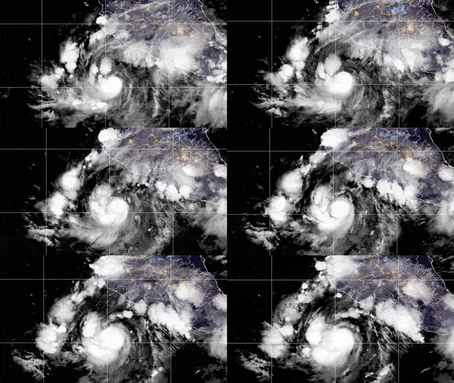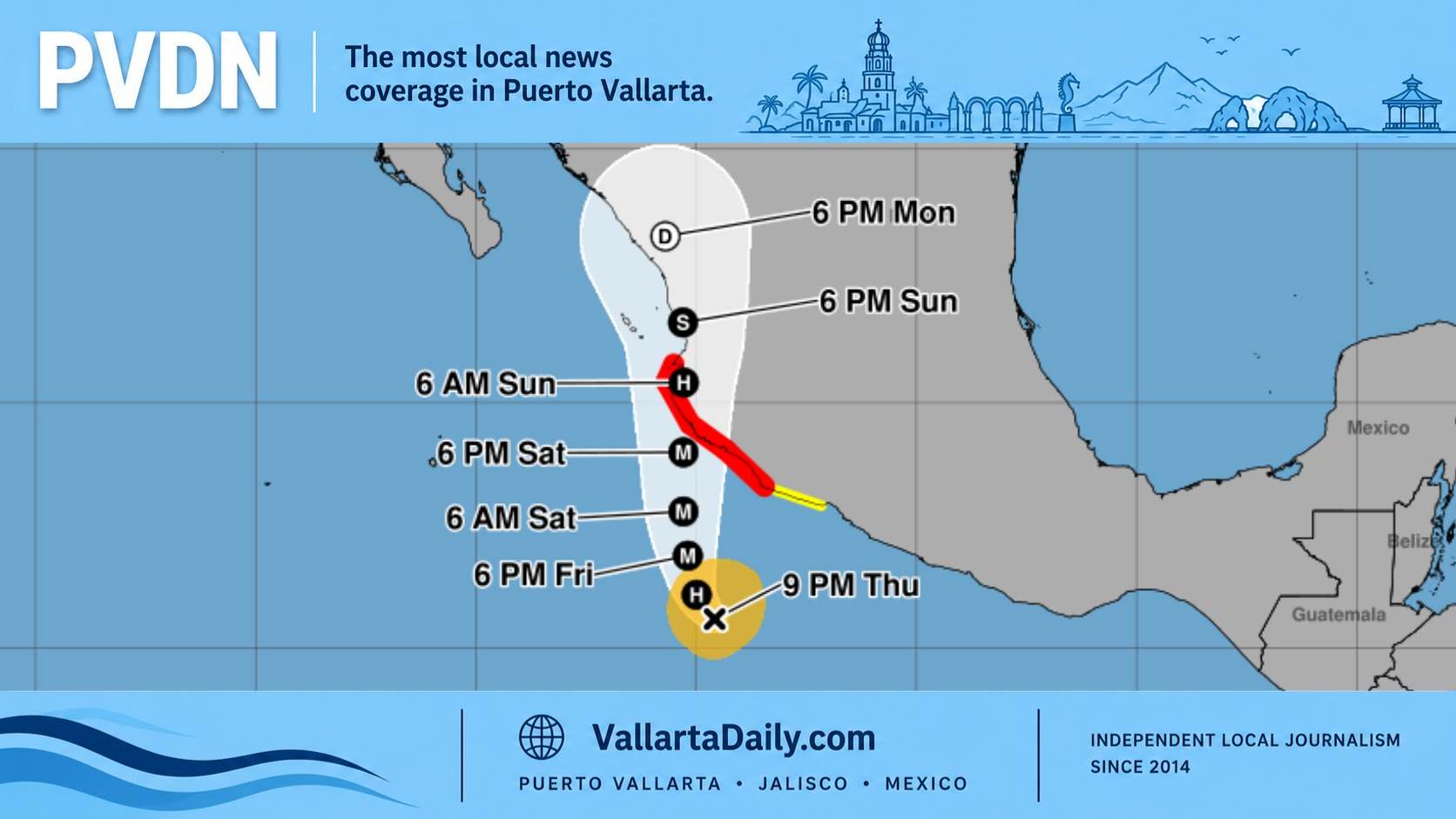
Puerto Vallarta, Jalisco, October 13, 2026 – Tropical Storm Trudy formed Tuesday and is forecast to become a major hurricane by Friday as it heads toward southwestern and west-central Mexico.
The National Hurricane Center’s 3 p.m. advisory reported sustained winds of 40 mph (65 km/h). No coastal watches or warnings were in effect for Trudy, but forecasters urged residents along those portions of Mexico’s coast to monitor its progress.
For Puerto Vallarta, the immediate question is how much danger the city could face as Trudy strengthens and moves north.
The NHC’s wind probability forecast gives Puerto Vallarta a 17% chance of experiencing sustained tropical-storm-force winds during the five-day period ending at noon Sunday, October 18. Those winds begin at 39 mph, or 63 km/h. The chance of stronger winds reaching at least 58 mph, or 93 km/h, was 3%.
Most of Vallarta’s forecast wind probability falls from noon Saturday through noon Sunday. Farther south, Manzanillo’s five-day probability of tropical-storm-force winds was substantially higher, at 57%.
These percentages describe the chance of winds reaching a particular location. They do not represent the probability of the storm’s center making landfall there, and they do not measure the danger from rainfall or rough seas.
Trudy’s official intensity forecast shows the storm becoming a hurricane Wednesday night, then reaching sustained winds of approximately 130 mph, or 210 km/h, by midday Friday. That strength is forecast to continue into Saturday before some weakening Sunday.
Under the Saffir-Simpson Hurricane Wind Scale, 130 mph is Category 4 strength. A major hurricane is Category 3 or higher. These categories describe the storm’s maximum sustained winds; they do not forecast wind speeds in Puerto Vallarta.
In the Tuesday afternoon forecast discussion, NHC forecaster Hagen wrote, “We are fairly confident it will become a strong hurricane.” Favorable ocean and atmospheric conditions are expected to support rapid strengthening over the next several days.
The storm’s eventual path is less certain. Trudy is expected to move generally west-northwest to northwest through Wednesday night, then turn north-northwest and slow Thursday as the weather systems steering it weaken.
The afternoon forecast shifted closer to Mexico’s coast. However, computer models differ more than usual about its position three to five days ahead, partly because Hurricane Simon’s position and strength could influence Trudy’s movement.
“Confidence in the track forecast remains low,” Hagen wrote. The NHC identified an increasing risk of wind, rain and storm surge along southwestern and west-central Mexico late this week and over the weekend, while leaving the precise locations and severity unresolved.
For people planning beach visits or boat trips, the advisory’s surf warning is also relevant: Trudy’s swells are expected to reach portions of southern Mexico’s coast late this week and could produce life-threatening surf and rip currents. The advisory does not give a specific arrival time or wave-height forecast for Banderas Bay.
The new storm comes as Vallarta restores services after Simon. Vallarta Daily’s October 13 local services report detailed scheduled school and municipal office reopenings alongside continuing beach restrictions.
This interval provides time to check preparations. Mexico’s National Center for Disaster Prevention recommends keeping emergency supplies and important documents accessible, checking evacuation routes, and clearing roofs and drains before a cyclone approaches. Its broader hurricane guidance also calls for securing loose objects that strong winds could carry.
For example, a condo owner can check with the building administrator about securing balcony furniture and clearing drainage outlets. Someone renting a house can identify who will handle those tasks before leaving town for the weekend.
Vallarta Daily’s 2026 hurricane coverage follows regional forecasts, official alerts, and local service changes as storms develop.
The next complete NHC advisory for Trudy is scheduled for 9 p.m. Tuesday, Puerto Vallarta time, and will provide the next update on its strength, track, and any coastal watches or warnings.