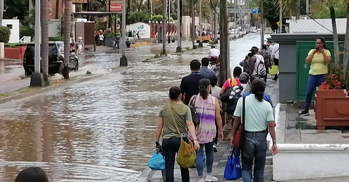
Over 60,000 Mazatlán residents face flood risks, especially near Jabalines Stream. Experts blame poor drainage, urban sprawl, and streambed invasions for repeated flooding.
In the Jacarandas neighborhood of Mazatlán, flood prevention is a way of life. Nearly every home is built above street level. Many residents have constructed barriers at their doorways or reinforced walls, trying to stay one step ahead of the rising waters.
Jacarandas is one of 94 communities situated along the Jabalines stream, an 11-kilometer waterway that has become the city’s most dangerous flood zone. When the rains come—and they always do—families brace themselves for the worst.
For Angélica Nevárez, who has lived on Cedros Street for over 15 years, the floods are more than an inconvenience. They’re a recurring trauma. “The first time it flooded, we lost everything,” she said. “The floor collapsed. Now, when heavy rains are expected, we move our furniture upstairs.”
The Jabalines stream wasn’t always a threat. Angélica says that when they bought the land, it didn’t seem like a risky area. But as nearby developments sprang up—many of them right along the streambed—the water had nowhere to go. Now, after every storm, the stream overflows with such force it swallows bridges and sweeps away anything in its path.
“We’ve seen animals, even a man in the current. It’s terrifying,” Angélica recalled.
Selling and moving elsewhere once seemed like an option. But with property values plummeting in flood-prone areas, many residents find themselves trapped. “No one wants to buy here anymore. People sell cheap and leave if they can,” she said.
60,000 Residents in High-Risk Zones
According to Mazatlán’s Municipal Risk Atlas, nearly 289 of the city’s 400+ neighborhoods are at high risk of flooding. That puts around 60,000 people in harm’s way each year, especially during tropical storm season.
The city sits just three meters above sea level, and the combination of outdated drainage systems, unauthorized construction along streams, and lack of flood control infrastructure has left entire communities exposed.
More than 40 percent of flood-vulnerable areas were developed without respecting the city’s natural water systems. In many neighborhoods, homes were built directly on or next to streambeds that were repurposed as streets. When rain falls, water has no natural route to drain—so it floods homes, businesses, and roads.
“The increasing population density puts pressure on land and services,” warns the Risk Atlas. “This leads to more construction on coastal land, unstable slopes, and flood-prone zones.”
Garbage, Drainage, and Man-Made Fillings Worsen the Crisis
Flooding in Mazatlán isn’t just about rainfall. Trash clogs the few drainage channels the city does have, and drainage collapses are common. Artificial fillings in lagoon systems like El Infiernillo, Urías, and Sábalo have degraded estuarine ecosystems that once acted as natural flood buffers.
In 2019, municipal officials conducted flood mapping using on-the-ground observations. The results were alarming:
- López Mateos neighborhood: Water levels reached up to 130 cm above the street
- Lico Velarde and Independencia: 115–125 cm
- Jacarandas and El Toreo: Up to 100 cm
With this year’s rains already causing major disruption, the issue of infrastructure deficiency is glaring. Streets and avenues regularly become impassable. The city has identified 44 intersections that routinely flood during storm season.
Yet the city’s rainwater disposal system remains woefully inadequate. Mazatlán currently relies on just:
- 2 collectors
- 6 ducts
- 7 channels
These are meant to serve a population of over half a million and divert stormwater across the entire city—a task they clearly cannot manage.
Key components of this network include:
- Gutiérrez Nájera Collector (Juan Carrasco to Del Mar Avenue)
- Roosevelt Collector (City Center)
- BanRural Duct (Camarón Sábalo Ave.)
- Lico Velarde Duct (Fovissste to Jabalines Stream)
- Rafael Buelna Pipeline (Jesús Kumate to La Marina Ave.)
- Zona Dorada Duct (Laguna Street to Sea)
- Francisco Solís Avenue Channel
- Col. López Mateos Canal
- Col. Zapata Canal
- Infonavit Alarcón and Playas Canals
Despite these efforts, flooding continues to paralyze critical parts of the city.
Civil Protection Urges Families to Prepare
In response to the escalating threat, Civil Protection Coordinator Óscar Roberto Osuna Tirado urges families to develop a family civil protection plan.
“Civil protection starts at home,” Osuna said. “Every family should know the risks, identify evacuation routes, and know where the nearest shelter or safe location is.”
He recommends preparing an emergency backpack that includes:
- Birth certificates
- Property deeds
- Vehicle titles
- Medical records
- Other essential documents in waterproof packaging
These small steps, he said, can make a major difference when disaster strikes.
Prevention Culture Needed as Climate Change Looms
Mazatlán’s vulnerability to tropical storms and heavy rains is not new—but the scale and frequency of the damage are growing. Urban planning decisions from decades past now endanger entire communities. And with climate change bringing more erratic weather, the time for passive risk management has passed.
Until major infrastructure investments are made and illegal developments along waterways are curbed, residents like Angélica Nevárez will continue to live in fear of the next flood.
“We can’t stop the rain. But we can prepare for it,” said Osuna. “And that starts with respecting the land, the water, and the people who live alongside both.”
Mazatlán flooding, Jabalines stream, Jacarandas neighborhood, flood risk Mazatlán, drainage system Mazatlán, Civil Protection Mazatlán, natural disasters Mexico