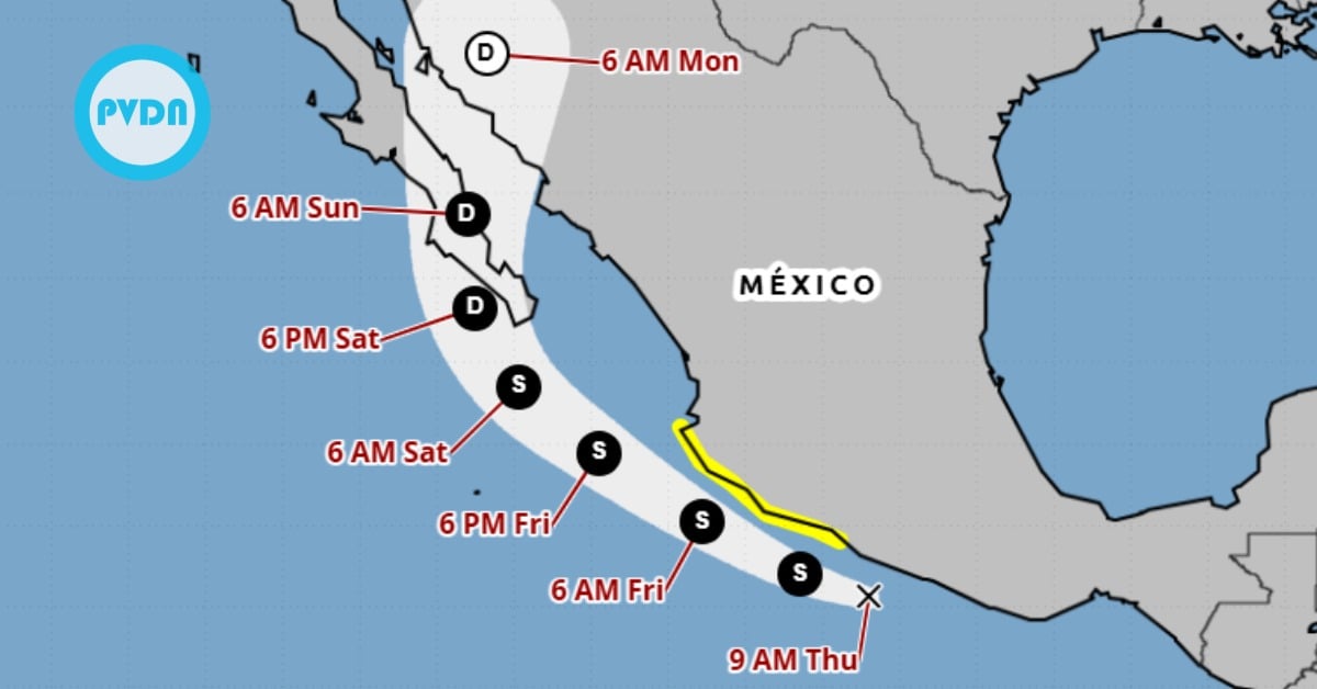
A fresh tropical system is sliding up Mexico’s Pacific coast, and Puerto Vallarta is back under watch. Early Thursday, forecasters tagged Tropical Depression 17-E just south of Guerrero, moving west-northwest over very warm water with strong rain bands and the potential to strengthen into Tropical Storm Raymond by Thursday evening. Mexico’s government issued a Tropical Storm Watch from Zihuatanejo to Cabo Corrientes—Puerto Vallarta’s doorstep—warning of dangerous surf, damaging gusts, and flooding rains through Friday night into Saturday. Locals remember this pattern. The coast is bracing again.
Puerto Vallarta tropical storm
Puerto Vallarta woke to an all-too-familiar alert: a developing cyclone tracking parallel to the coast with the bay in the watch window. At 9:00 a.m. CST Thursday, the National Hurricane Center classified the system as Tropical Depression 17-E, centered near 16.2°N, 100.8°W, moving west-northwest with maximum sustained winds of about 35 mph. The government of Mexico issued a Tropical Storm Watch from Zihuatanejo to Cabo Corrientes, which includes Banderas Bay. The NHC expects tropical-storm conditions to be possible within 36 hours along that stretch. Puerto Vallarta tropical storm risk is not theoretical; it’s on the official board.
Forecasters say the system is organized with active convective bands and a defined center. Warm sea-surface temperatures along the track and favorable near-term conditions support gradual strengthening, with a high chance of reaching tropical-storm status later today. U.S. and Mexican meteorological agencies warn of heavy rains through at least Saturday, with the most significant impacts focused along coastal sections of southwestern Mexico. Flooding in low-lying areas and quick-rising arroyos is the primary threat in Jalisco and Nayarit, followed by downed trees and sporadic power lines in stronger squalls.
What to expect in the bay
The watch area includes Cabo Corrientes—the south gate to the bay—so any wobble closer to shore would amplify local wind and surf. The National Meteorological Service placed a surveillance zone from Lázaro Cárdenas, Michoacán, to Cabo Corrientes for strong winds and high waves, matching the NHC track that keeps the center running roughly parallel to the coastline through late Friday. Local outlets in the bay are already flagging the scenario that the system, once named Raymond, could brush closest to Puerto Vallarta on Friday before weakening later in the weekend. Rains should intensify Thursday night into Friday.
Authorities urge residents and visitors to avoid beaches during rough surf, secure loose items, and watch official channels for any upgrade from watch to warning. With soils already primed from recent systems in the eastern Pacific, even a glancing blow can trigger landslides in the Sierra and street flooding in the flats. Civil Protection asks people to monitor SMN, Conagua, and municipal alerts rather than social media rumor mills. If you live in flood-prone colonias, plan parking and commutes around the heaviest bands Friday into early Saturday.
Context check, names and timing: The next available eastern-Pacific name on the 2025 list is Raymond, which multiple official and media briefings expect if the depression reaches 39-mph sustained winds. As of this morning’s advisory, the system had not yet been named, but the probability of strengthening within 48 hours remains high. Watches can shift quickly; if the center jogs inland or weakens, risks ease. If it tightens and tracks closer to shore, short-notice warnings are possible. Keep receipts handy for travel changes and follow hotel guidance.
At a glance—what’s official right now (Thursday, Oct. 9, a.m. CST):
Tropical Depression 17-E is off Guerrero, moving WNW; Mexico has a Tropical Storm Watch from Zihuatanejo to Cabo Corrientes; heavy rain, rough surf, and gusty winds are expected along the Jalisco-Nayarit coast through at least Friday night. That’s the baseline; details will sharpen with each advisory.