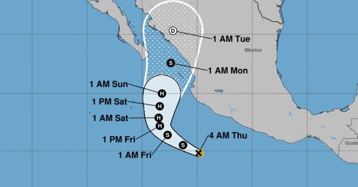
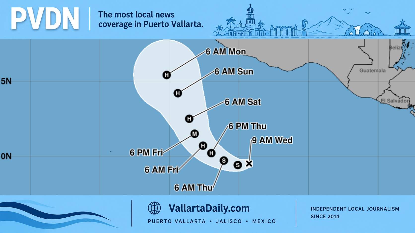
UPDATE OCTOBER 3, 2022 – 6:15 AM CST
This morning there is little rain and an increase in waves, however, at this time, Hurricane Orlene seems to have spared Puerto Vallarta the worse of her, once category 4, strength.
As of 4 AM, the Mexican Government was still forecasting heavy rains, winds of 30-35 mph, and waves of 2 meters for today.
The Mexican Government maintains its Hurricane Watch status for Puerto Vallarta. Orlene was downgraded to a category 2 hurricane in the early morning hours.
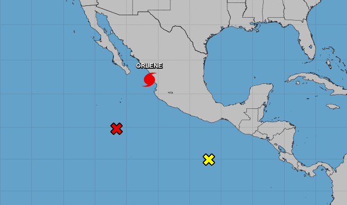
There are also two more system with a high probablity of formation this week in the Pacific.
UPDATE OCTOBER 2, 2022 – 10:15 PM CST
“Orlene” is downgraded to a category 2 hurricane on the Saffir-Simpson scale as its center moves over Islas Marías, Nay. Its cloud bands produce intense rains, winds and high waves on the coasts of Sinaloa, Nayarit, Jalisco, and Colima. The forecast rains could cause an increase in the levels of rivers and streams, landslides, and floods in low-lying areas of the indicated states.
At 9:50 PM, the loudspeaker alert system in Puerto Vallarta announced that Orlene was passing by Puerto Vallarta and to remain vigilant.
Orlene is moving toward the north near 8 mph (13 km/h), and a general northward to north-northeastward motion is expected to continue over the next day or so. On the forecast track, the center of Orlene will is forecast to move over Las Islas Marias tonight, and reach the coast of mainland Mexico within the warning area on Monday.
Maximum sustained winds have decreased to near 105 mph (165 km/h) with higher gusts. Weakening is expected during the next day or so, but Orlene is forecast to remain a hurricane when it reaches southwestern Mexico.
UPDATE OCTOBER 2, 2022 – 9:15 PM CST
Still no effects from Hurricane Orlene in Puerto Vallarta. People walking the Malecon and vendors selling in the streets. Let’s see what Orlene brings us through the night. The forecast was late Sunday night and early Monday morning… Authorities warn the backend of the storm pushing water into the bay and generating heavy rains after the passing of Orlene early Monday morning.
UPDATE OCTOBER 2, 2022 – 7:15 PM CST
- Schools closed and additional civil protection agents deployed in Puerto Vallarta for Hurricane Orlene – read the story
- Puerto Vallarta International Airport will close operations from today at 9 pm and until 8 am tomorrow, Monday.
UPDATE OCTOBER 2, 2022 – 4:15 PM CST
The National Coordination of Civil Protection reported that the forecast for Orlene will change to category 1 on Monday evening, impacting the southern coast of Sinaloa and northern Nayarit between the municipalities of Escuinapa, Rosario, Tecuala and continue its journey to Durango.
There will be gusts of wind of 90 to 110 kilometers per hour in the parts of Nayarit and Jalisco, as well as gusts of 60 to 70 km/h on the coasts of Sinaloa and Colima.
According to the National Water Commission (Conagua), the hurricane is expected to impact the afternoon-night of Monday, October 3 in southern Sinaloa, mainly affecting Mazatlán, El Rosario, Concordia, and San Ignacio.
In addition, the authorities pointed out that the main attention is paid to Nayarit — the state in which the greatest amount of damage is expected to be recorded — because the effects will be seen starting today afternoon with torrential rains of more than 48 hours.
Meanwhile, the advance of the hurricane continues in a northerly direction. At 13:00 on Sunday, the SMN reported that it is located 135 km west-southwest of Cabo Corrientes and 245 km southwest of San Blas. In a joint press conference, the authorities called to attend to the instructions issued by the security forces.
UPDATE OCTOBER 2, 2022 – 4:00 PM CST
Conagua (Mexico’s weather service) and the National Civil Protection confirmed that the force of Hurricane Orlene will begin to be felt in Puerto Vallarta this evening during a live broadcast on their Facebook page.
Maximum sustained winds are near 115 mph (185 km/h) with higher gusts. Orlene is a category 3 hurricane on the Saffir-Simpson Hurricane Wind Scale. Weakening is expected during the next day or so, however, Orlene is forecast to be a strong hurricane when it passes near Puerto Vallarta, and remain a hurricane when it reaches southwestern Mexico.
Although the satellite presentation of Orlene is not as impressive as it was overnight, the center is still embedded within an area of cloud top temperatures of -70 to -80 degrees Celsius. The eye is also not as defined in conventional satellite imagery as earlier today, but an Air Force Force Reserve reconnaissance aircraft that made two passes through the center earlier this afternoon reported a closed 22-mile-wide eye on its final pass.
It has been difficult to determine if today’s weakening was caused by an eyewall replacement cycle, the increase in southwesterly shear, or a combination of both. Regardless, southwesterly vertical wind shear is forecast to increase during the next 12 to 24 hours, which is expected to cause an additional reduction in wind speed, plus the entrainment of some drier mid-level air to the west of Orlene. Orlene still is forecast to pass near Jalisco and Islas Marias as a strong hurricane tonight, and reach the coast of mainland Mexico as a hurricane by on Monday. After landfall, rapid weakening is expected, and the low-level center should dissipate over the mountainous terrain of southwestern Mexico in 48-60 hours.
Satellite imagery and fixes from the aircraft show that Orlene is still moving northward or 005/7 kt. The track forecast philosophy is unchanged from before. Orlene should bend north-northeastward tonight as it is steered between a mid-level ridge to its east and a broad trough over northwestern Mexico.
UPDATE OCTOBER 2, 2022 – 2:30 PM CST
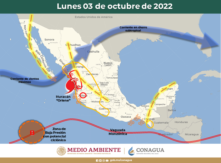
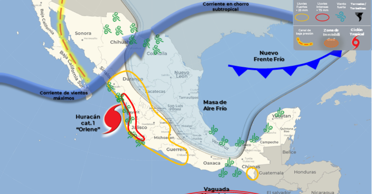
The category 3 hurricane “Orlene” will move very close to the coast of Jalisco, its cloud bands will cause intense to punctual torrential rains in Nayarit and Jalisco, very heavy rains to intense punctual rains in Sinaloa and Colima; and heavy to very heavy rains in Durango and Michoacán. In turn, intense winds are expected with gusts of 90 to 110 km/h and high waves of 3 to 5 meters in height on the coasts of Nayarit and Jalisco, and winds with gusts of 60 to 70 km/h and waves of 1 to 3 meters high on the coasts of Sinaloa and Colima.
UPDATE OCTOBER 2, 2022 – 1:00 PM CST
On the forecast track, the center of Orlene should pass near or over Las Islas Marias tonight or Monday morning, and reach the coast of mainland Mexico within the warning area later on Monday or Monday night.
Maximum sustained winds are near 115 mph (185 km/h) with higher gusts. Orlene is a category 3 hurricane on the Saffir-Simpson Hurricane Wind Scale. Weakening is expected during the next day or so, however, Orlene is forecast to be a strong hurricane when it passes near Puerto Vallarta and the Islas Marias, and remain a hurricane when it reaches southwestern Mexico.
Hurricane-force winds extend outward up to 15 miles (30 km) from the center and tropical-storm-force winds extend outward up to 70 miles (110 km).
Civil Protection Committee declares itself in permanent session
Due to the proximity to which Hurricane “Orlene” is expected to pass, the Scientific Committee for Civil Protection of Puerto Vallarta-Bahía de Banderas declared a preventive alert due to the possible effects that the phenomenon could bring to the region.
It was reported that this Sunday the hurricane will pass approximately 110 kilometers from the Bay, so its proximity would cause more effects than initially expected.
UPDATE OCTOBER 2, 2022 – 10:35 AM CST
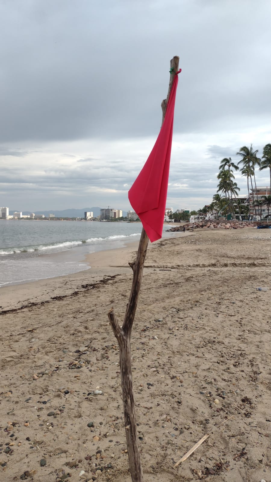
All beaches in Puerto Vallarta are under red flag warning, meaning please do not enter the water.
UPDATE OCTOBER 2, 2022 – 9:55 AM CST
- Orlene shows slight weakening and is downgraded to category 3
- Even with slight weakening, Orlene is expected to brush near the coast of Puerto Vallarta tonight as a major hurricane
A turn toward the north-northeast is expected later today. On the forecast track, the center of Orlene should pass near or over Las Islas Marias tonight or Monday morning, and reach the coast of mainland Mexico within the warning area later on Monday or Monday night.
Maximum sustained winds are near 125 mph (205 km/h) with higher gusts. Orlene is a category 3 hurricane on the Saffir-Simpson Hurricane Wind Scale. Weakening is expected during the next day or so, however Orlene is forecast to be a strong hurricane when it passes near Puerto Vallarta or over the Islas Marias, and remain a hurricane when it reaches southwestern Mexico.
Hurricane-force winds extend outward up to 15 miles (30 km) from the center and tropical-storm-force winds extend outward up to 70 miles (110 km).
Hurricane conditions are expected in Las Islas Marias tonight, with tropical storm conditions beginning today. Hurricane conditions are expected in the warning area along the coast of mainland Mexico late Monday, with tropical storm conditions beginning early Monday.
Tropical storm conditions are expected to spread northward in the tropical storm warning area today through early Monday. Hurricane conditions are possible along the coast of mainland Mexico within the hurricane watch area by tonight or early Monday, this includes Puerto Vallarta.
Orlene is expected to produce the following rainfall across portions of Southwest Mexico through Tuesday:
- Islas Marias: 6 to 10 inches, with local amounts of 14 inches.
- Nayarit and Sinaloa: 3 to 6 inches with local amounts of 10
inches. - Jalisco and Colima: 1 to 3 inches with local amounts of 5 inches.
These rainfall amounts will likely lead to flash flooding, as well as possible landslides in areas of rugged terrain.
A dangerous storm surge is likely to cause coastal flooding along the coast of mainland Mexico in the warning area in regions of onshore winds.
Large swells generated by Orlene are affecting the west coast of Mexico and will spread northward to the southern portion of the Baja California peninsula and the Gulf of California over the next couple of days. These swells are likely to cause life-threatening surf and rip current conditions.
***
The satellite presentation of Orlene has degraded since early this morning. It appears that an increase in southwestern shear may have begun, as the eye has become cloud filled. Based on the degraded
satellite presentation, the initial intensity has been reduced to 110 kt. An Air Force Reserve reconnaissance aircraft is currently en route to investigate the hurricane, and should provide additional information on the strength and size of the wind field early this afternoon.
Orlene has likely peaked in intensity. Although the sea surface temperatures remain warm along the forecast track, increasing southwesterly vertical wind shear during the next 24 to 36 hours is likely to cause the small hurricane to weaken. However, Orlene is forecast to pass near Puerto Vallarta as a strong
hurricane late tonight or early Monday, and reach the coast of mainland Mexico has a hurricane by late Monday or Monday night.
After landfall, rapid weakening is expected and the low-level center should dissipate over the mountainous terrain of southwestern Mexico in 60-72 hours.
Key Messages:
Hurricane conditions are expected in the Islas Marias tonight, with tropical storm conditions beginning today. A Hurricane Warning is in effect for a portion of west-central mainland Mexico, where hurricane conditions are expected on Monday with tropical storm conditions beginning early Monday. Preparations to protect life and property should be rushed to completion.
UPDATE OCTOBER 2, 2022 – 6:15 AM CST
Orlene is a category 4 hurricane off the Jalisco coast.
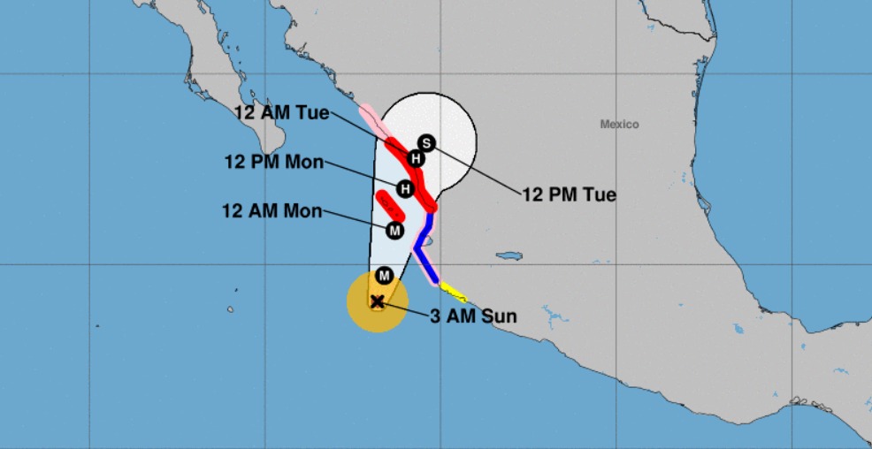
Puerto Vallarta has been placed under a hurricane watch, an increase in the previous alert of a tropical storm warning. Overnight on Saturday, Orlene rapidly strengthened to a category 4 storm and is expected to pass close to the Puerto Vallarta, Jalisco coast on Sunday night and into Monday morning. Maximum sustained winds are near 130 mph (215 km/h) with higher gusts.
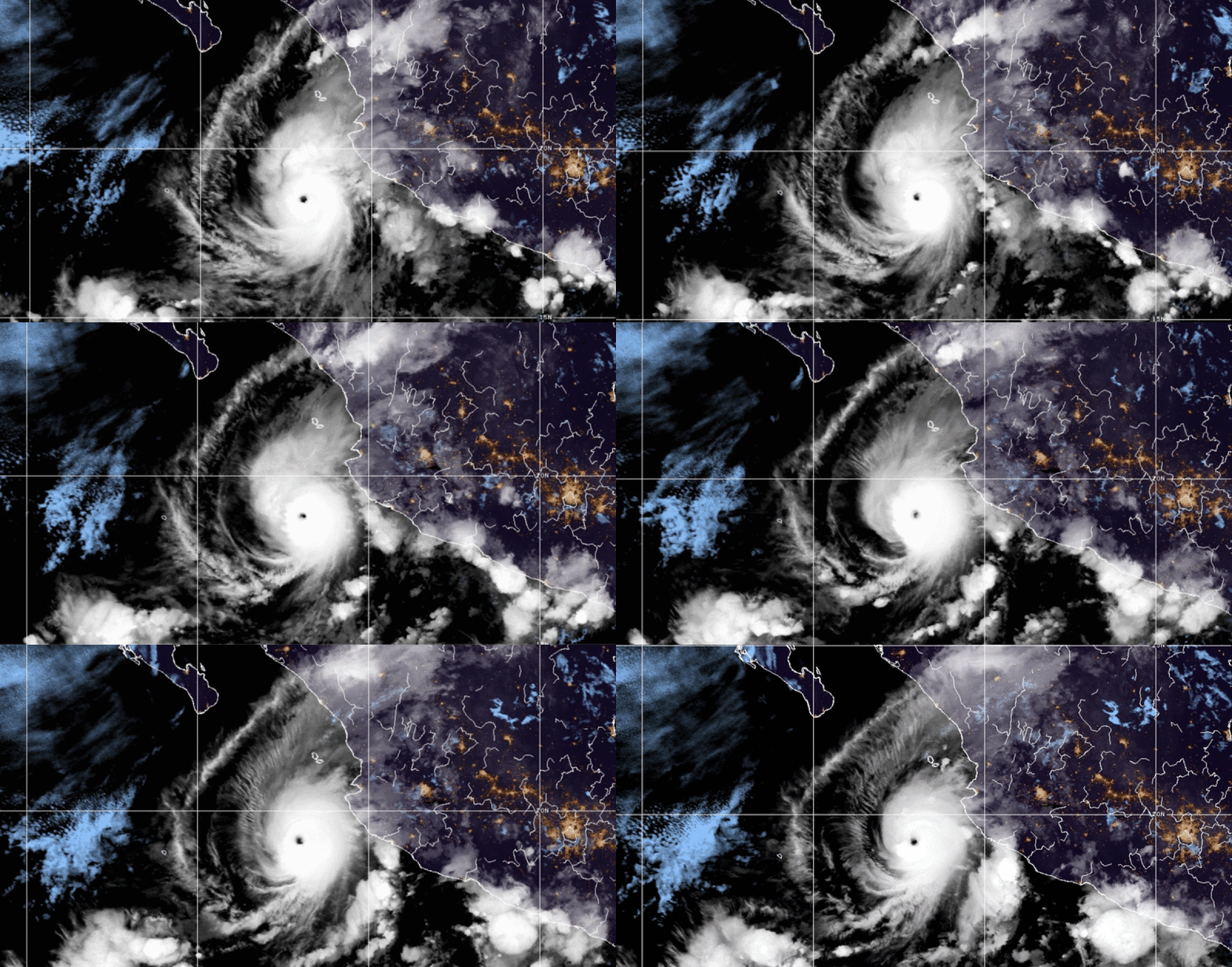
For Sunday the hurricane “Orlene”, category 4 on the Saffir-Simpson scale, will move near the coast of Jalisco. Its cloud bands will cause intense to torrential rains in areas of Nayarit and Jalisco, very strong to intense in Colima and Sinaloa (south), as well as very heavy rains in Durango. These rains could cause an increase in the levels of rivers and streams, landslides, and floods. Its circulation will generate gusts of wind of 90 to 110 km/h and waves of 3 to 5 meters high on the coasts of Nayarit and Jalisco, as well as gusts of 60 to 70 km/h and waves of 1 to 3 meters high on the coasts of Colima and Sinaloa.
In the short term, environmental conditions are expected to be conducive for further strengthening, with moderate vertical shear prevailing for the next 12 hours or so. Thereafter, although thermodynamic factors should remain conducive, the global models show a substantial increase in southwesterly vertical shear over the hurricane.
Orlene’s recent strengthening, the official intensity forecast is above all of the model predictions. It is anticipated that the system will be at or near hurricane strength when it reaches the coast of mainland
Mexico. After landfall, the cyclone will quickly weaken over the mountainous terrain.
Orlene continues moving northward or at about 005/6 kt. During the next 48 hours or so, the hurricane should be steered by the flow between the mid/upper-level trough near Baja California and northwestern Mexico and a subtropical ridge to its east. A slight bend of the heading toward the north-northeast is likely later today.
Hurricane conditions are expected in the Islas Marias tonight, with tropical storm conditions beginning later today. A Hurricane Warning is in effect for a portion of west-central mainland Mexico, where hurricane conditions are expected on Monday with tropical storm conditions beginning early Monday. Preparations to protect life and property should be rushed to completion.
UPDATE OCTOBER 2, 2022 – 12:00 AM CST
Puerto Vallarta has been upgraded to a hurricane watch. A Hurricane Watch means that hurricane conditions are possible within the watch area. A watch is typically issued 48 hours before the anticipated first occurrence of tropical-storm-force winds, conditions that make outside preparations difficult or dangerous.
Orlene is a rapidly strengthening hurricane. The intensity of the cyclone has increased by 35 kt in the past 18 h, and the satellite presentation of Orlene has continued to improve this evening. A warm and well-defined eye has emerged.
The environmental conditions appear conducive for additional strengthening during the next 12 h or so, while the hurricane moves within a low deep-layer shear environment and over very warm waters. The latest NHC intensity forecast shows Orlene peaking as a major hurricane on Sunday.
UPDATE OCTOBER 1, 2022 – 7:00 PM CST
Orlene continues to strengthen rapidly and a more organized hurricane eye has developed.
A north-northeastward motion at a slightly faster speed is expected to begin by tonight and continue through early next week. On the forecast track, the center of Orlene should pass near or over Las Islas Marias Sunday night or Monday morning and reach the coast of mainland Mexico later on Monday or Monday night.
Satellite intensity estimates indicate that maximum sustained winds have increased to near 105 mph (165 km/h) with higher gusts. Additional strengthening is forecast through Sunday afternoon.
Orlene is a small tropical cyclone. Hurricane-force winds extend outward up to 10 miles (20 km) from the center and tropical-storm-force winds extend outward up to 45 miles (75 km).
UPDATE OCTOBER 1, 2022 – 6:30 PM CST
This is a special update: Satellite data indicate that Orlene is rapidly strengthening and moving faster than the original forecast, with maximum sustained winds estimated to be 105 mph (170 km/h). A special advisory will be issued in the next half hour to update any forecast based on the rapid increase of Hurricane Orlene.
UPDATE OCTOBER 1, 2022 – 3:30 PM CST
- Hurricane Orlene is a small storm but is continuing to gain strength
- Tropical storm conditions could reach Puerto Vallarta early Sunday morning
Orlene is moving toward the north near 5 mph (7 km/h). A north-northeastward motion at a slightly faster speed is expected to begin by tonight and continue through early next week. On the forecast track, the center of Orlene should pass near or over Las Islas Marias Sunday night or Monday morning and reach the coast of mainland Mexico later on Monday or Monday night.
Reports from an Air Force Reserve Hurricane Hunter aircraft indicate that maximum sustained winds have increased to near 80 mph (130 km/h) with higher gusts. Additional strengthening is forecast through Sunday afternoon. Steady to rapid weakening is expected starting Sunday night and continuing until landfall.
Aircraft and satellite wind data indicate that Orlene remains a small tropical cyclone. Hurricane-force winds extend outward up to 10 miles (20 km) from the center and tropical-storm-force winds extend outward up to 45 miles (75 km).
Hurricane conditions are expected in Las Islas Marias Sunday night, with tropical storm conditions beginning late Sunday. Tropical storm conditions are expected in the tropical storm warning
area by early Sunday, this includes Puerto Vallarta. Hurricane conditions are possible along the coast of mainland Mexico within the hurricane watch area by Sunday night into Monday. Tropical storm conditions are possible along the coast of mainland Mexico within the tropical storm watch area tonight and Sunday.
Next update at 10:00 PM CST
UPDATE OCTOBER 1, 2022 – 10:00 AM CST
Orlene has strengthened to a hurricane off the coast of Jalisco.
Maximum sustained winds have increased to near 75 mph (120 km/h) with higher gusts. Strengthening is expected through Sunday. After that, steady weakening is expected to begin by Sunday night. An Air Force Reserve Hurricane Hunter aircraft is currently enroute to investigate Orlene.
Orlene remains a small tropical cyclone. Hurricane-force winds extend outward up to 10 miles (20 km) from the center and tropical-storm-force winds extend outward up to 45 miles (75 km).
Coastal flooding is likely, please take precautions.
Hurricane conditions are expected in Las Islas Marias Sunday night, with tropical storm conditions possible by late Sunday. Tropical storm conditions are expected in the tropical storm warning area by early Sunday. Hurricane conditions are possible along the coast of mainland Mexico within the hurricane watch area by Sunday night into Monday. Tropical storm conditions are possible along the coast of mainland Mexico within the tropical storm watch area tonight and Sunday.
UPDATE OCTOBER 1, 2022 – 6:00 AM CST
Tropical Storm “Orlene” continues its slow movement to the north, off the coast of Jalisco and Colima. Its cloud bands will produce heavy to very heavy rains in western Mexico, with intense rains in areas of Colima and Jalisco.
Wind is forecast with gusts of 60 to 70 km/h and waves of 2 to 4 meters high on the coasts of Nayarit and Jalisco, as well as gusts of 40 to 50 km/h and waves of 1 to 2 meters high on the coasts of Colima and Sinaloa (south).
Hurricane conditions are possible in the Islas Marias Sunday night, with tropical storm conditions beginning late Sunday. Tropical storm conditions are expected within the tropical storm warning area along the west-central coast of Mexico on Sunday, including Puerto Vallarta.
Take extreme precautions for the population in general in the areas of the states mentioned due to rain, wind, and waves (including maritime navigation) and attend to the recommendations issued by the authorities of the National Civil Protection System, in each entity.
UPDATE SEPTEMBER 30, 2022 – 10:00 PM CST
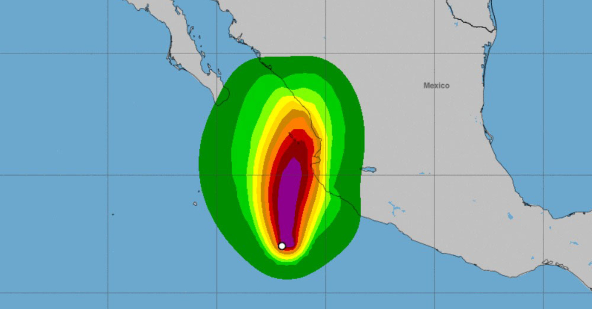
Puerto Vallarta has been upgraded to a Tropical Storm Warning from a previous Tropical Storm Watch. A Tropical Storm Warning means that tropical storm conditions are expected somewhere within the warning area, generally within 36 hours.
HAZARDS AFFECTING LAND
WIND: Hurricane conditions are possible in Las Islas Marias on Sunday, with tropical storm conditions possible Saturday night and Sunday. Tropical storm conditions are expected in the warning area by early Sunday. Tropical storm conditions are possible along the coast of mainland Mexico Saturday night and Sunday.
RAINFALL: Into Monday evening, Orlene is expected to produce 3 to 5 inches of rainfall, with local amounts of 10 inches, for portions of southwestern Mexico. These rainfall amounts should lead to flash flooding, as well as possible landslides in areas of rugged terrain.
STORM SURGE: Coastal flooding is likely along the coast of Mexico in the warning area in regions of onshore winds.
SURF: Large swells generated by Orlene will affect the coast of southwestern Mexico, and the extreme southern portion of the Baja California peninsula by this weekend. These swells are likely to cause life-threatening surf and rip current conditions. Please consult products from your local weather office.
Latest:
- The Secretary of the Navy (Semar) has closed all ports on the Mexican Pacific due to Orlene.
- For this Friday night and early this Saturday, very heavy punctual rains (from 50 to 75 millimeters [mm]) are expected in the states of Colima, Guerrero, Jalisco, Michoacán, and Sonora.
- The forecast rains could be with lightning and hail, in addition to causing landslides, increased levels of rivers and streams, overflows and flooding in low-lying areas.
Next update will be October 1, 2022 at 6:00 AM, or before if any any changes in the forecast is made before the next scheduled update.
UPDATE SEPTEMBER 30, 2022 – 5:50 PM CST
As noted in the last advisory, Orlene is forecast to be in a moist, low-shear environment and over warm sea surface temperatures for the next 24-36 hours. These conducive conditions, combined with the small storm size, should allow steady to rapid strengthening as the core convection becomes more symmetric and concentrated.
The initial motion is now north-northwestward or 335/4 kt. Orlene is on the southwest side of a mid-to-upper-level ridge over central Mexico, and water vapor imagery shows a developing mid-to-upper-level trough over northwestern Mexico and the northern Baja California peninsula. Orlene should turn northward and north-northeastward between these features during the next day or so, with this general motion continuing for the rest of the forecast period.
The new forecast track, which again is similar to the previous forecast, calls for the system to pass west of Cabo Corrientes and near the Islas Marias and off the coast of Puerto Vallarta in about 48 hours and then make landfall on the mainland coast of Mexico.
The forecast track and wind radii require a Hurricane Watch for Las Islas Marias and a Tropical Storm Watch for a portion of mainland Mexico, including Puerto Vallarta, at this time. Additional watches and warnings will likely be required tonight or on Saturday.
Key Messages:
- Hurricane conditions are possible in the Islas Marias on Sunday, where a hurricane watch has been issued. Tropical storm conditions are possible over portions of southwestern and west-central Mexico in the tropical storm watch area, which includes Puerto Vallarta.
- Heavy rainfall from Orlene is expected to lead to flash flooding, as well as possible landslides in areas of mountainous terrain of Southwest Mexico into Monday afternoon.
UPDATE SEPTEMBER 30, 2022 – 3:35 PM CST
If you live in Puerto Vallarta, or own a property in Puerto Vallarta, you already know if you are located in a flood zone, prepare now if you are in those areas.
The Government of Mexico has issued a Hurricane Watch for Las Islas Marias, and a Tropical Storm Watch for the coast of mainland Mexico from Manzanillo to San Blas, this includes Puerto Vallarta.
A Tropical Storm Watch means that tropical storm conditions are possible within the watch area, generally within 48 hours.
Maximum sustained winds have increased to near 65 mph (100 km/h) with higher gusts. Steady to rapid strengthening is expected through Saturday night, and Orlene is forecast to become a hurricane tonight or Saturday.
Orlene remains a small tropical cyclone. Tropical-storm-force winds extend outward up to 45 miles (75 km) from the center.
WIND: Hurricane conditions are possible in Las Islas Marias on Sunday, with tropical storm conditions possible Saturday night and Sunday. Tropical storm conditions are possible along the coast of mainland Mexico Saturday night and Sunday.
RAINFALL: Into Monday afternoon, Orlene is expected to produce 3 to 5 inches of rainfall, with local amounts of 10 inches, for portions of the Southwest Mexican coast. These rainfall amounts should lead to flash flooding, as well as possible landslides in areas of mountainous terrain.
STORM SURGE: Localized coastal flooding is possible along the coast of Mexico in the watch areas in regions of onshore winds.
SURF: Large swells generated by Orlene will affect the coast of southwestern Mexico and the extreme southern portion of the Baja California peninsula by this weekend. These swells are likely to cause life-threatening surf and rip current conditions.
Next update will be at 10:00 PM unless circumstances change and an earlier alert needs to be issued.
UPDATE SEPTEMBER 30, 2022 – 9:45 AM CST
Orlene has not changed much in organization during the past several hours, with satellite imagery showing a small central dense overcast with ragged outer convective banding.
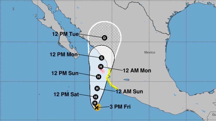
Orlene is forecast to be in a moist, low-shear environment and over warm sea surface temperatures for the next 48 hours. These conducive conditions, combined with the small inner core, should allow steady to rapid strengthening once the core convection becomes more symmetric. Based on this, the intensity forecast shows the system reaching a peak intensity of 85 kt, nearly 100 MPH (or 160 kmh) in the next 48 hours.
Orlene should turn northward and north-northeastward during the next couple of days, with this general motion continuing for the rest of the forecast period. The new forecast track, which is similar to the previous forecast, calls for the system to pass west of Cabo Corrientes and near the Islas Marias in 48-60 hours and then make landfall on the mainland coast of Mexico just after 96 hours.
Watches will likely be required for portions of the western coast of Mexico and the Islas Marias on the next advisory.
The next update will be made at 4:00 PM CST unless significant changes require another update before that time.
UPDATE SEPTEMBER 30, 2022 – 6:00 AM CST
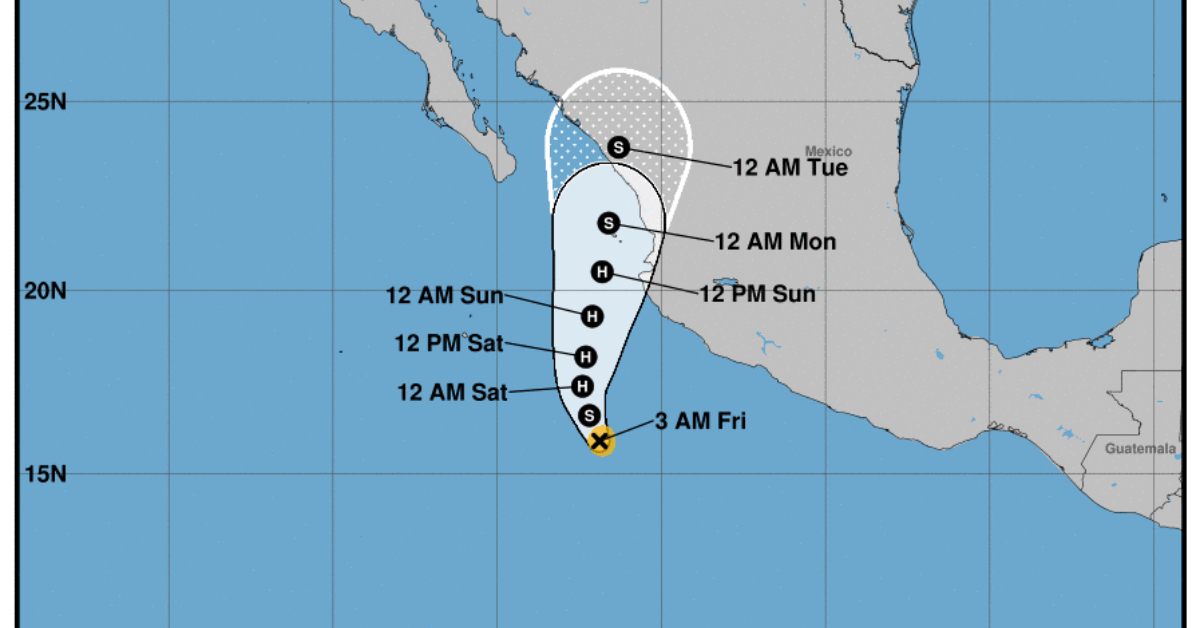
Tropical Storm Orlene continues to strengthen off the coast of Jalisco, the newest update shows Orlene tracking closer to Puerto Vallarta than originally forecasted and putting Vallarta within the cone of probability for landfall.
UPDATE SEPTEMBER 29, 2022 – 8:00 PM CST
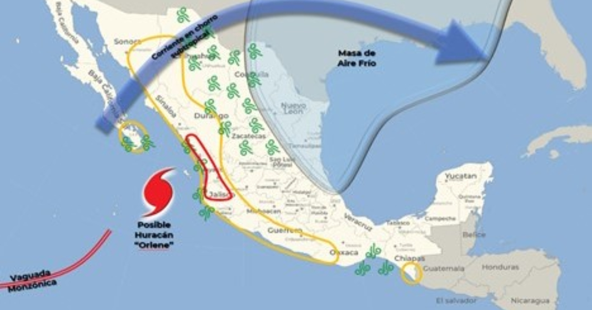
Saturday is forecasted to be the most intense in Puerto Vallarta for weather brought to the area as Hurricane Orlene passes along the coast of Jalisco.
Here is what to expect on Saturday, October 01:
Very strong rains with intense punctual (75 to 150 mm): Sinaloa, Nayarit and Jalisco.
Heavy rains with very strong points (50 to 75 mm): Colima, Michoacán, Guerrero, Oaxaca and Chiapas.
Wind with gusts of 60 to 70 km/h and waves of 2 to 4 meters in height: coasts of Nayarit and Jalisco.
UPDATE SEPTEMBER 29, 2022 – 4:00 PM CST
Orlene is moving toward the west-northwest near 8 mph (13 km/h). A turn toward the northwest is expected tonight, followed by a turn toward the north on Friday. Orlene is forecast to turn toward the north-northeast by Saturday.
Maximum sustained winds are near 45 mph (75 km/h) with higher gusts. Steady to rapid strengthening is expected during the next couple of days, and Orlene is forecast to become a hurricane Friday night or Saturday.
Tropical-storm-force winds extend outward up to 35 miles (55 km) from the center.
Large swells generated by Orlene will affect the coast of southwestern Mexico, including Jalisco and the coast of Puerto Vallarta.
By Friday afternoon, there will be a clearer understanding of the storm movement and how close it could pass to Puerto Vallarta within its forecasted tracking cone.
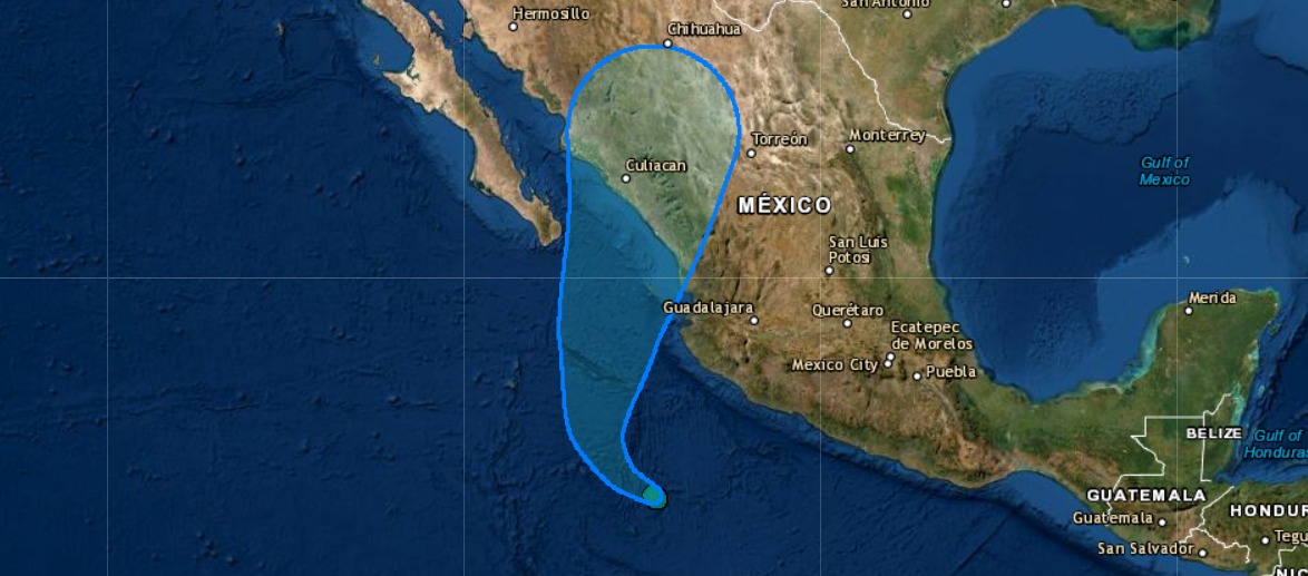
UPDATE SEPTEMBER 29, 2022 – 8:00 AM CST
Tropical Storm Orlene is located 465 km south of Manzanillo, Col. and 600 km south-southeast of Cabo Corrientes, Jal.
The circulation of this system reinforces the rain potential in western Mexico, producing showers with strong punctual rains (25 to 50 mm) in Michoacán, Colima, and Jalisco.
Wind is forecast with gusts of 50 to 60 km/h and waves of 1 to 2 meters high on the coasts of Michoacán, Colima, and Jalisco.
Take extreme precautions for the population in general in the areas of the states mentioned due to rain, wind, and waves (including maritime navigation) and attend to the recommendations issued by the authorities of the National Civil Protection System, in each entity.
Next Update: September 29 at 4:00 PM