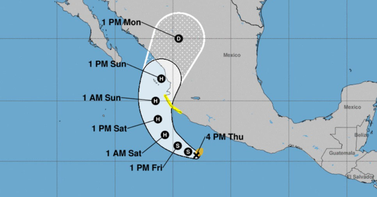
A tropical storm watch has been issued from Manzanillo to Cabo Corrientes due to Tropical Storm Roslyn, expected to strengthen into a hurricane on Friday. It is likely that the warning will be extended to the Puerto Vallarta area sometime Friday.
A Tropical Storm Watch means that tropical storm conditions are possible within the watch area, generally within 48 hours.
Subscribers, log in to your PVDN Dashboard for live tracking and alerts. Not a subscriber, subscribe today.
Satellite imagery shows that Roslyn has become a little more organized this afternoon, and some strengthening over the last several hours. Models are all in agreement that Roslyn will make landfall in Western Mexico, although not all are in agreement about where, as it’s too early to predict. However, models have landfall between Cabo Corrientes and Nayarit, putting Puerto Vallarta in the center cone of uncertainty.
The outer rainbands of Tropical Storm Roslyn may produce rainfall totals of 1 to 3 inches along coastal areas of Guerrero and Michoacán and 2 to 4 inches with maximum amounts of 6 inches along coastal areas of Colima and Jalisco. This rainfall could lead to flash flooding as well as possible landslides in areas of rugged terrain.
Roslyn is then forecast to turn north and northeast this weekend and may bring locally heavy rainfall to coastal areas of Nayarit including Islas Marias, and southeastern Sinaloa. This rainfall could lead to flash flooding and landslides in areas of rugged terrain.
Swells generated by Roslyn are affecting portions of the coast of southwestern Mexico and will spread northward to the coast of west-central Mexico by Friday. These swells are likely to cause life-threatening surf and rip current conditions.
Roslyn remains over warm sea surface temperatures in a moist, light-shear environment. These conditions are likely to persist for the next 60-72 h, and they should allow Roslyn to steadily intensify. After that time, the intensity forecast becomes more uncertain due to a forecast increase in shear, the possibility of
dry air entrainment, and the uncertainty of how much land interaction will occur. The new intensity forecast is again similar to the previous forecast and calls for a peak intensity of 85 kt before landfall in mainland Mexico. After landfall, rapid weakening is expected, with the cyclone dissipating over the mountains of Mexico between 96-120 h.