Cabo Corrientes no longer under tropical storm watch as Hurricane Flossie nears Mexico’s Pacific coast, with dangerous winds and heavy rains threatening Michoacán, Colima, and Jalisco.
The tropical storm watch for Cabo Corrientes was officially canceled Tuesday, offering a measure of relief for the scenic coastal town as Hurricane Flossie continues to churn off Mexico’s Pacific coast. While Cabo Corrientes is now expected to avoid the worst of the storm’s impacts, other regions remain in Flossie’s path—and at risk.
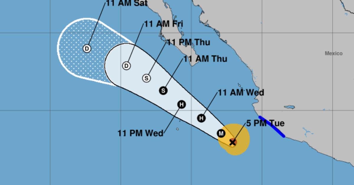
A Tropical Storm Warning is still active from Punta San Telmo to Playa Pérula, covering parts of Michoacán, Colima, and Jalisco, where residents are being warned of dangerous winds, heavy rainfall, and flash flooding through Wednesday.
As of the latest advisory, Flossie is holding steady with maximum sustained winds of 110 mph (175 km/h), with stronger gusts near the storm’s center. The hurricane-force winds stretch outward up to 25 miles (35 km), while tropical-storm-force winds affect areas up to 90 miles (150 km) from the core.
Cabo Corrientes Avoids Direct Impact
The decision to lift the tropical storm watch for Cabo Corrientes came after updated forecasts indicated that the storm’s trajectory had shifted slightly. Officials now believe the area will escape the brunt of the tropical-storm-force winds, which had previously posed a threat to the town and surrounding communities.
While the cancellation is welcome news for locals and tourists, authorities still urge caution along the coastline due to rough seas, heavy surf, and unpredictable swells that could impact the area over the next few days.
Threat Remains for Other Coastal States
While Cabo Corrientes may be in the clear, Michoacán, Colima, and Jalisco remain under serious threat. Forecasters expect 1 to 2 inches of additional rain, with isolated maximum totals of 4 inches, raising the risk of flash floods and localized landslides.
Coastal towns in these states are already experiencing tropical storm conditions, with gusty winds and saturated ground conditions that could worsen overnight. The heaviest impacts are expected through Wednesday.
Dangerous Surf and Rip Currents
Swells generated by Flossie are affecting much of southwestern Mexico’s coastline and are forecast to continue impacting parts of the Baja California peninsula as well. These conditions are likely to create life-threatening surf and rip currents, even in areas outside the warning zone, including Cabo Corrientes.
Local authorities are urging residents and visitors to stay away from beaches and waterfronts, noting that the ocean remains unpredictable during active storm systems—even when direct wind threats are downgraded.
Flossie Expected to Weaken After Tonight
Although Flossie remains a powerful hurricane for now, forecasters anticipate a steady to rapid weakening beginning late Tuesday or early Wednesday. The system is expected to lose intensity as it encounters cooler waters and increased wind shear.
However, the immediate threat of damaging winds, flooding rains, and coastal hazards remains high, especially in the warning zones. Civil protection authorities in Michoacán, Colima, and Jalisco have activated emergency plans, opened shelters, and remain on high alert.
Stay Informed and Prepared
Even though the storm’s intensity is projected to decline, its potential to cause significant damage—particularly from flooding and coastal erosion—should not be underestimated.
Those in affected areas should monitor updates from:
- Mexico’s National Meteorological Service (SMN)
- The U.S. National Hurricane Center (NHC)
- State and municipal civil protection agencies
Travelers are encouraged to confirm itineraries, remain indoors during peak storm activity, and avoid driving through flooded streets.
For Cabo Corrientes, the cancellation of the storm watch is a positive development—but for much of Mexico’s Pacific coast, Hurricane Flossie still poses a serious threat.
Cabo Corrientes no longer under tropical storm watch as Hurricane Flossie nears Mexico's Pacific coast, with dangerous winds and heavy rains . . .


