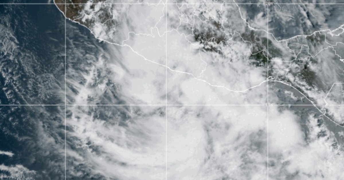
Tropical Depression Two-E formed close enough to Mexico’s southern Pacific coast to trigger official warnings, with Guerrero and Oaxaca facing the hardest rain and Jalisco watching the ocean side of the forecast. The system remains broad and slow, but forecasters expect it to intensify before making landfall. For Puerto Vallarta, the question is less about landfall and more about what its outer moisture, wind and swell do along the wider coast tonight and Monday.
Tropical Depression Two-E forms near Guerrero
Tropical Depression Two-E formed Sunday off Mexico’s southern Pacific coast, putting Guerrero and Oaxaca under a tropical storm warning and pushing Jalisco coastal conditions into a rougher forecast.
By the 6 p.m. CST update from the National Hurricane Center advisory, the system was about 160 kilometers, or 100 miles, south-southeast of Acapulco, with maximum sustained winds near 55 km/h, or 35 mph. It was moving east-northeast at about 6 km/h, slow enough to keep rain bands feeding into the same stretch of coast.
Federal forecasters in Mexico said earlier that the depression was close enough to trigger a prevention zone from Lagunas de Chacahua, Oaxaca, to Técpan de Galeana, Guerrero, according to the latest SMN cyclone briefing. The same briefing said the system could strengthen into a tropical storm before reaching land tonight or early Monday.
If it reaches tropical storm strength, the next name on the Eastern Pacific list is Boris, according to the National Hurricane Center storm name list. As of the latest advisory, though, it was still Tropical Depression Two-E, not a named storm.
Jalisco gets the edge of the storm field
Puerto Vallarta is not inside the tropical storm warning zone. That warning sits farther south, along the Guerrero and Oaxaca coast. Still, Jalisco is not out of the forecast.
The 4 p.m. SMN advisory placed southern Jalisco under a very heavy rain forecast of 50 to 75 millimeters, or roughly 2 to 3 inches. It also called for gusts of 40 to 60 km/h, or 25 to 37 mph, along the coasts of Jalisco, Colima, and Michoacán, with surf of 2 to 3 meters, or about 6.5 to 10 feet, on the same stretch of coast.
Puerto Vallarta is not forecast to be a landfall point, but the wider Jalisco coast can still see rough surf, choppy bay conditions, and bursts of rain from the outer moisture field. That wider pattern was already visible Saturday in an earlier Pacific storm monitoring update, as two systems developed off southern Mexico.
The strongest rain threat remains south of here. SMN called for torrential rainfall of 150 to 250 millimeters, or 6 to 10 inches, in western and coastal Guerrero. Oaxaca and Michoacán were placed under forecasts of intense rainfall, while Colima and southern Jalisco were included in the very heavy rain band.
Flooding risk sits over steep terrain
Rainfall is the main danger from Two-E, more than wind at this stage.
The National Hurricane Center said in its forecast discussion that heavy rain from the depression will affect parts of southern Mexico and is likely to produce “life-threatening flooding and mudslides,” especially in steep terrain. It’s 6 p.m., and a public advisory projects 4 to 10 inches of rain across coastal Guerrero and Oaxaca, with isolated totals near 12 inches possible through Monday night.
Mexico’s weather agency warned of landslides, rising rivers and streams, overflow risk, and flooding in low-lying areas, according to the 4 p.m. SMN advisory. Those are the same hazards that often appear before wind speeds become the headline.
Federal emergency officials said they had deployed coordination missions to Oaxaca and Guerrero, while Conagua said response teams and equipment were ready in regional operation centers. In the joint briefing, Nadia Tadeo Benítez of the national civil protection system said, “being prepared is the most valuable tool we have to safeguard life.”
Forecast keeps the system close to land
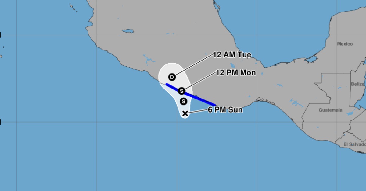
The depression is broad and not especially fast-moving. That makes the forecast messy. It also keeps the rainfall window open longer than a quick-moving storm would.
The National Hurricane Center expects the center to approach Mexico’s coast within the warning area on Monday. Forecast guidance showed modest strengthening before landfall, with the system weakening inland and dissipating by Tuesday if the track holds.
For Puerto Vallarta, the next checks are coastal surf, port conditions, and evening rain bands. Any navigation limits, beach warnings, or local closures would be issued by Mexican maritime and civil protection authorities.
Amanda became the first named storm of the 2026 Eastern Pacific season earlier in the week, and Two-E is now the next system close enough to Mexico to bring direct coastal impacts. The hurricane coverage page is tracking the season as federal forecasters update the Pacific outlook.