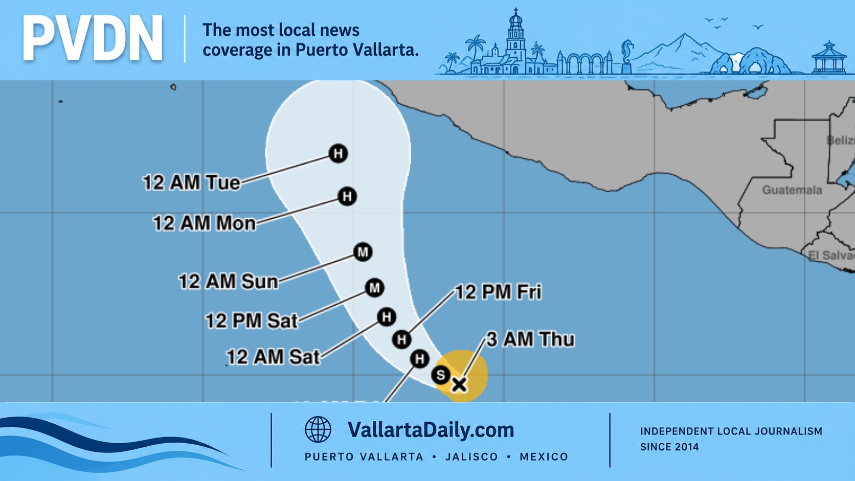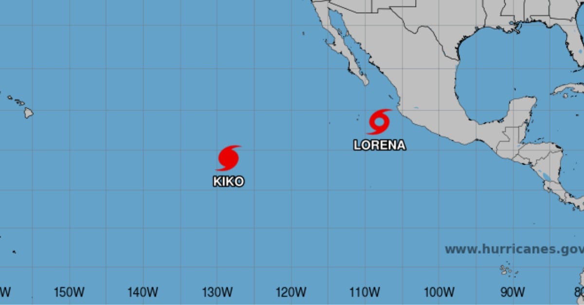
Tropical Storm Lorena took shape this morning over the eastern Pacific. At 9:00 a.m. in Mexico City (1500 UTC), the center was near 18.3°N, 107.9°W—roughly 325 km (200 miles) west-southwest of Playa Pérula, Jalisco, and about 330 km (205 miles) southwest of Cabo Corrientes at the mouth of Bahía de Banderas. That puts Lorena well offshore of the Jalisco–Colima coast but aligned with familiar reference points for anyone in Puerto Vallarta, Manzanillo, or the Chamela–Cuixmala stretch. The National Hurricane Center (NHC) says no watches are in effect yet, but that may change for Baja California Sur later today or Wednesday.
Tropical Storm Lorena
Satellite loops early today showed a compact core tightening up, with colder cloud tops wrapping closer to the center—classic signs the storm has found a more favorable pocket of atmosphere. Overnight, NHC estimated top winds near 35–40 kt (65–75 km/h) and expected a steady ramp-up; the morning advisory upgrades the system to Tropical Storm Lorena with maximum sustained winds near 45 mph (75 km/h) and gusts higher. Tropical-storm-force winds extend about 55 km (35 miles) from the center. Forecast guidance continues to strengthen over the next 24–48 hours, with a potential push to hurricane strength by Wednesday if the inner core consolidates further.
The steering pattern is straightforward at first—Lorena rides the southwest edge of a mid-level ridge and heads northwest at ~22 km/h (14 mph). After midweek, the forward speed eases and the path begins to hook north, then northeast toward the Baja California peninsula. There’s still spread among models on timing and how sharply Lorena turns, a common problem when a small cyclone intensifies near a weakness in the ridge. In short, Baja California Sur needs to track updates closely, even as exact wind impacts remain too early to pin down.
What this means on land
Well east and northeast of the center, rain bands are already fanning across the mainland from Colima up to Sinaloa today, with isolated flash flooding possible in mountainous terrain. Beginning Wednesday, Baja California Sur comes into play as moisture curls toward the peninsula. NHC’s current outlook calls for 4–8 inches (100–200 mm) in parts of BCS and southwestern Sonora through Friday, with local peaks to 12 inches (300 mm) if slow-moving bands set up. That’s enough to trigger dangerous flash flooding and mudslides, particularly along arroyos and steep canyon walls.
Where Lorena is now, in everyday terms
Mariners and meteorologists think in lat/long, but residents don’t. Today’s 18.3°N, 107.9°W puts the storm off the Jalisco coast, southwest of the Chamela–Cuixmala–Playa Pérula corridor and southwest of Cabo Corrientes, well away from land but roughly aligned with the Manzanillo–Puerto Vallarta arc. If you’re picturing the map, Lorena sits out to sea west of Jalisco/Colima, angling toward the southern Baja waters in the next two to three days.
Intensity signals to watch
Lorena has warm water and ample mid-level moisture beneath it for another day or two, which favors gradual strengthening. By late week, the track crosses cooler waters near the 26 °C isotherm and encounters increasing shear—typically a sign of weakening before or after any approach to land. That push-pull between strengthening now and environmental headwinds later is why forecasts highlight uncertainty on peak intensity. Residents should prepare for tropical-storm conditions at a minimum while staying open to an upgrade if the inner core organizes more quickly than expected.
A familiar name, a different storm
If “Lorena” rings a bell, it’s because the name was last used in 2019, when a hurricane by the same name skirted Jalisco and made landfall in Baja California Sur before sending heavy rain into Sonora and the U.S. Southwest. Today’s Lorena is a different system in a different year, but the history is a reminder that slow-moving bands over rugged terrain are often the most significant hazard. Use the past as context, not a forecast.
What to do now in Baja California Sur and the mainland
There is no watch or warning on the coast as of this morning, but that may change quickly as the turn toward Baja firms up. Ports, schools, and civil protection agencies in Los Cabos, La Paz, Comondú, and Mulegé typically move early when watches go up; keep an eye on local announcements and NHC advisories this afternoon and tonight. If you live near arroyos or steep slopes in BCS or southwestern Sonora, plan around fast-rising water during heavy bands Wednesday through Friday.
[vd_follow taxonomy=”post_tag” term_slug=”hurricane” label_follow=”Follow Hurricane News” label_unfollow=”Following”]