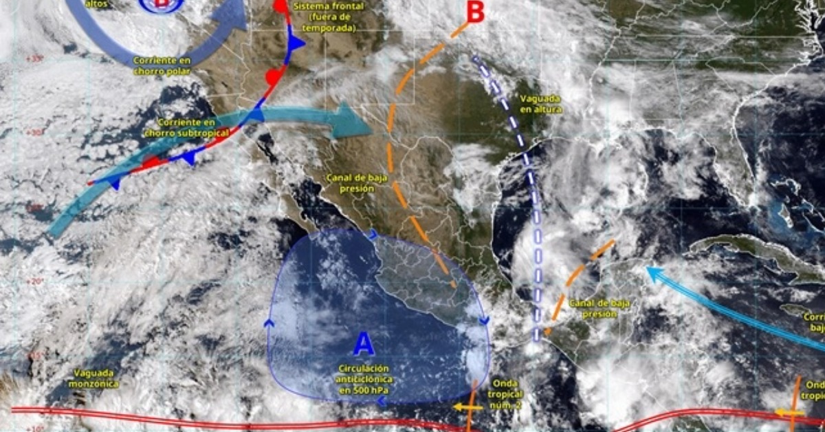
Mexico will close May under a broad tropical rain pattern. The strongest downpours are expected over the southeast and the Yucatán Peninsula. Much of the country still faces storms, heat, and gusty winds.
The latest forecast from the Servicio Meteorológico Nacional places Tropical Wave 2 south of Oaxaca and Guerrero. It is interacting with humid air from the Gulf of Mexico and the Caribbean. A trough over the Gulf and southeastern Mexico is adding lift. Together, those systems could bring electrical storms, hail, and strong gusts before June begins.
The heaviest rain outlook is concentrated in Chiapas, Tabasco, Campeche, and Yucatán. Those areas could receive 75 to 150 millimeters of rain in spots. Oaxaca, southern Veracruz, and Quintana Roo are under a lower but still serious band of 50 to 75 millimeters.
Tropical waves move into a charged pattern
The forecast is not based on a single feature. A broader weather summary also notes another tropical wave approaching the Yucatán Peninsula. That system could increase rain, wind, and elevated seas into the weekend.
Conagua describes a tropical wave as a low-pressure channel moving westward with the trade winds. In plain terms, it is a moving belt of unstable tropical air. It can help organize storms as they pass. That risk grows when warm seas, humid air, and upper-level conditions line up.
That does not mean a cyclone has formed. It does mean the atmosphere is becoming more active. The Pacific season is already open, and the Atlantic season is days away. CENAPRED notes in its cyclone guidance that Mexico’s Pacific cyclone season begins in May, while the Atlantic season begins in June. Both run into late November.
Flooding risk sits behind the forecast numbers
Rain totals are only part of the warning. The federal forecast points to possible landslides, river and stream rises, overflows, and flooding in low areas where the strongest storms develop.
The bulletin warned of “landslides, increased levels of rivers and streams,” and “overflows and floods” in low areas.
The same rain band can also produce sudden wind gusts. Forecast details call for gusts of 50 to 70 kilometers per hour in San Luis Potosí, Jalisco, Guerrero, Campeche, and Yucatán. Dust storms are possible in parts of the north and west. Yucatán and Quintana Roo also face waves of 1.5 to 2.5 meters along exposed coasts.
Jalisco is not in the heaviest rain zone in this forecast. It is listed for showers and strong wind gusts. That distinction matters for Puerto Vallarta because the current concern is less about a nearby cyclone. The issue is the seasonal pattern turning wetter.
Puerto Vallarta has already been watching the early season. Last week, the first tropical wave raised concerns about rain in southern Mexico. The city was also preparing for its own shift toward wetter afternoons. Local officials and forecasters have framed the 2026 season as active, as covered in our guide to how Puerto Vallarta is preparing for a busy cyclone season.
Heat continues while storms build
The same forecast keeps the heat in place across a large part of Mexico. The heat wave is expected to persist in parts of Sinaloa, Nayarit, Jalisco, Colima, Michoacán, Morelos, Guerrero, Oaxaca, Chiapas, Campeche, and Yucatán.
Maximum temperatures of 40 to 45 degrees Celsius are expected in parts of Sinaloa, Chihuahua, Nayarit, Michoacán, Guerrero, Oaxaca, and Yucatán. Other states, including Jalisco, Colima, Tabasco, Campeche, and Quintana Roo, could see highs of 35 to 40 degrees.
The combination is uncomfortable and unstable. Hot afternoons can feed stronger storms later in the day when moisture and lift are present. In coastal and mountain areas, the weather can shift quickly from heat to heavy rain.
The federal outlook urges people to follow official weather bulletins and Protección Civil guidance. The message is direct because the first systems of the season often arrive before people adjust to daily rain, slick roads, drainage problems, and rougher seas.