Cyclone Alvin: Low-Pressure Zone off Pacific Coast With 80% Chance of Development

Puerto Vallarta, Mexico – SMN and Conagua track Cyclone Alvin potential south of Michoacán, Guerrero and Oaxaca, with an 80% chance of development within seven days; public urged to stay alert.

The National Meteorological Service (SMN), working alongside the National Water Commission (Conagua), monitors a low-pressure zone off Mexico’s Pacific coast with an 80% chance of developing into Cyclone Alvin within the next seven days. If the system organizes into a tropical cyclone, it will receive the first name on this year’s Eastern Pacific list: Alvin. Meteorologists emphasize that a clear circulation and sustained winds will confirm its status, while satellite imagery and model guidance will shape forecasts in the coming days.

Fun Fact: In meteorology, a cyclone is any low-pressure system with counterclockwise rotation in the Northern Hemisphere (or clockwise in the Southern Hemisphere). The term cyclone can be used to describe these storms anywhere they form in the world, the term is not unique to only storms in the South Pacific and Indian Oceans. Everywhere you see strong, organized storms with sustained winds of at least 119 km/h (74 mph), they’re classified as tropical cyclones.

The possible formation sits roughly south of Michoacán, Guerrero and Oaxaca, stretching off coastal towns like Lázaro Cárdenas, Acapulco and Puerto Escondido. This low-pressure area currently drifts slowly away from land across sea-surface temperatures that favor storm growth. Its broad circulation envelope spans hundreds of kilometers, making precise tracking challenging. Meteorologists rely on frequent satellite scans and ocean buoys to monitor wind patterns and pressure drops. As the system develops, forecasters will refine positional data and issue updated advisories.

Conagua notes the feature moves at a sluggish pace that amplifies uncertainty about its future path. Should the disturbance maintain its westward drift, it may track parallel to the coast without making landfall. Alternatively, an eventual northward turn could bring moisture into coastal valleys, increasing rain risks for inland communities. Forecasters will watch atmospheric steering currents closely, including nearby high-pressure ridges or troughs that influence direction. Understanding these patterns will prove vital to anticipating any shift toward populated areas.

Even without direct landfall, the system could generate heavy rains across the coastal belt of Michoacán, Guerrero and Oaxaca. Authorities warn of flash floods, landslides and beach erosion as storm-driven waves push onshore. High surf could reach three to five meters in exposed sectors, endangering small craft and swimmers. Gusty winds may exceed 60 kilometers per hour in gusts, damaging trees and vulnerable structures. Residents in low-lying zones and river basins should prepare for rapid water level rises. Emergency services in these areas remain on standby to respond to potential incidents.

If the system progresses into a tropical cyclone, the SMN will classify it as a tropical depression, then upgrade it to a tropical storm and assign the name Alvin. “Alvin” ranks first on this season’s Eastern Pacific naming roster, which the World Meteorological Organization updates in six-year cycles. Hurricane season in this basin runs from May 15 through November 30, peaking from July to September. Early-season formations like Alvin can still grow rapidly when oceanic and atmospheric conditions align, underscoring the need for vigilant monitoring.

Meteorological authorities urge the public to stay informed by following official channels and to heed Civil Protection recommendations if conditions change. Residents should compile an emergency kit with water, food, medications and essential documents. They should also secure loose objects around homes, trim overhanging branches and clear drainage outlets. People living near rivers or steep terrain must identify evacuation routes and establish a communication plan with family. Local shelter locations and alert levels may change as the situation evolves.

State-level Civil Protection agencies in Michoacán, Guerrero and Oaxaca have begun reviewing emergency protocols and coordinating with municipal officials. Officials plan to staff temporary shelters in low-lying communities and pre-position equipment for flood response. Conagua has shared projected rainfall maps to guide decision-making at the local level. Meanwhile, fishing fleets have received advisories to avoid venturing into open waters until the threat subsides. Communities can expect updated risk assessments in each new bulletin. School authorities may suspend coastal activities pending further updates.

The next official update is due within 24 hours, when SMN and Conagua will release fresh bulletins on development probability and track forecasts. Satellite passes and computer models should yield clearer insight into whether formation odds remain high. International agencies, including the National Oceanic and Atmospheric Administration, also contribute data to refine outlooks. News outlets and social media platforms will carry the latest advisories. Readers can find live updates on the SMN website and Conagua’s Twitter feed.

While forecasters remain cautious about predicting exact impacts, the current outlook calls for focused attention on coastal regions from late May onward. Authorities will monitor wind shear levels and ocean heat content to gauge intensification potential. Fishermen, tourists and local businesses should adjust plans to factor in possible storm disruptions. Hotels and resorts along the Pacific coast may face brief closures or service changes. Clear communication and timely action can help communities weather any severe conditions.

As the Pacific waters warm further in the coming weeks, meteorologists expect more disturbances to appear off the Mexican coast. The fate of “Cyclone Alvin” will hinge on subtle shifts in atmospheric patterns, but the public can act now to minimize risk. By tracking official forecasts, following Civil Protection guidance and preparing basic supplies, residents can stay safe under evolving weather threats. For now, all eyes remain on that low-pressure zone rolling over the vibrant Pacific shoreline.

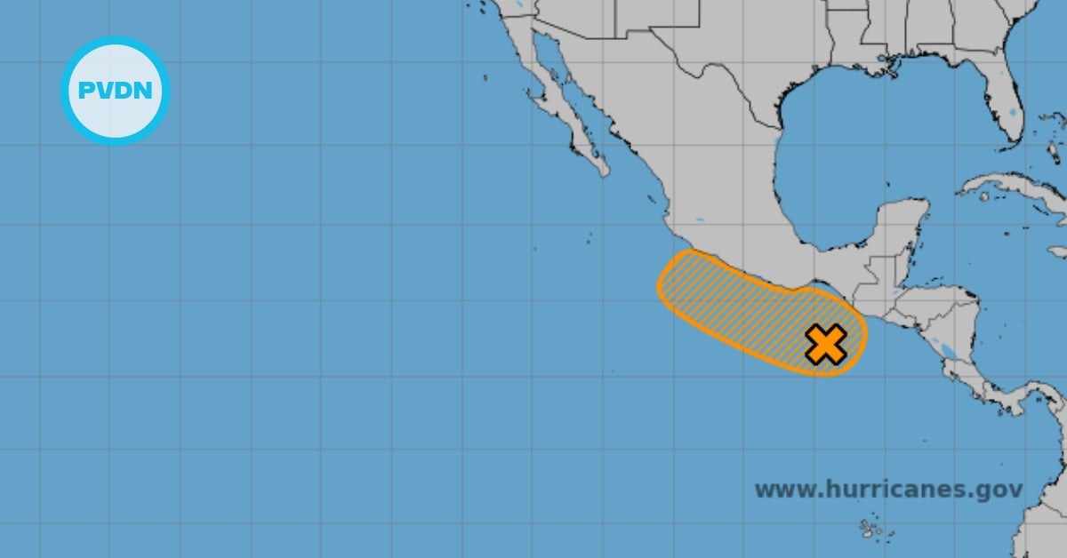
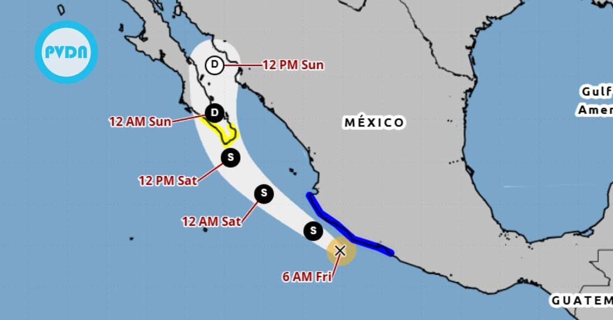
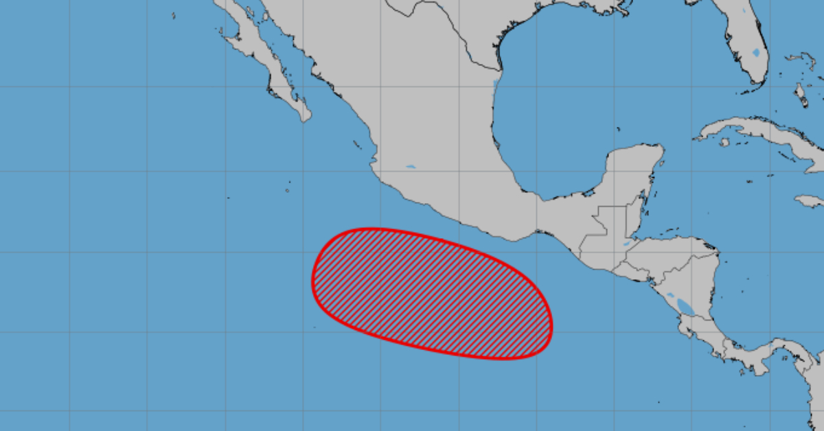
Puerto Vallarta, Mexico - SMN and Conagua track Cyclone Alvin potential south of Michoacán, Guerrero and Oaxaca, with an 80% chance of development within seven days; public urged to stay alert.

Follow Us On Google News | Get Our Newsletter


Trending News on PVDN

  • puerto-vallarta-rainfall-hurricane-flossie-july-2025Puerto Vallarta braces for torrential rains as Hurricane Flossie gains strength Puerto Vallarta faces a high risk of flooding as Hurricane Flossie intensifies in the Pacific. Torrential rains and overwhelmed drainage systems pose major challenges for the city. Puerto Vallarta, a city wedged between the Sierra Madre mountains and the Pacific Ocean, is no stranger to dramatic weather shifts—but this summer, the skies are testing the…
  • hurricane-flossie-strengthens-july-1-2025Hurricane Flossie will bring tropical storm conditions to parts of Guerrero, Michoacán, Colima, and Jalisco Hurricane Flossie intensifies off Mexico's Pacific coast with winds near 90 mph. Heavy rain, flooding, and tropical storm conditions expected in parts of Guerrero, Michoacán, Colima, and Jalisco. Hurricane Flossie continued to intensify early Tuesday morning as it moved west-northwestward off the coast of southwestern Mexico, prompting tropical storm warnings and watches across multiple states.…
  • raw-sewage-playa-los-muertos-puerto-vallartaMore Raw Sewage Dumping at Playa Los Muertos Appear to Come From Local Hotel Business owners in Puerto Vallarta are demanding action after raw sewage was discovered leaking onto Playa Los Muertos, raising public health and tourism concerns. A raw sewage leak at Playa Los Muertos in Puerto Vallarta has sparked outrage among local tourist service providers and business owners, who say the contamination is driving away visitors and…
  • tropical-storm-flossie-hurricane-mexico-pacific-coastTropical Storm Flossie to Strengthen into Hurricane as It Tracks Along Mexico’s Pacific Coast Tropical Storm Flossie is expected to become a Category 2 hurricane by July 2 as it moves parallel to Mexico’s Pacific coast, bringing dangerous rainfall, wind, and surf. Tropical Storm Flossie is on the verge of forming from Tropical Depression Six-E and is forecast to strengthen rapidly into a hurricane as it parallels Mexico’s southwestern…
  • tropical-storm-flossie-strengthens-mexico-june-2025Tropical Storm Flossie Strengthens Off Mexico’s Pacific Coast, Could Become Hurricane by Tuesday Tropical Storm Flossie gains strength off southwestern Mexico, with hurricane status possible by Tuesday. Storm warnings issued from Punta San Telmo to Playa Perula. Tropical Storm Flossie continues to gain strength off Mexico’s Pacific coastline, prompting tropical storm warnings and watches across several southwestern states. According to the National Hurricane Center (NHC), Flossie is expected…
  • oregon-murder-fugitive-extradited-puerto-vallartaFugitive Wanted for 2008 Oregon Homicide Captured in Puerto Vallarta and Extradited to U.S. Jesús Rodríguez Borrayo, a fugitive for 17 years, was extradited from Mexico to Oregon for his role in a 2008 drive-by shooting that left one dead. He was located in Puerto Vallarta. A man wanted for murder and other violent crimes in the United States for nearly two decades has been extradited after being found…
  • tropical-storm-flossie-mexico-coast-rain-surf-alertCabo Corrientes under tropical storm watch as Flossie expected to Bring Heavy Rain and Dangerous Surf to Southwestern Mexico Tropical Storm Flossie is forecast to strengthen and may impact Mexico's southwest coast from Zihuatanejo to Cabo Corrientes with heavy rain, flooding, and hazardous surf early this week. Tropical Storm Flossie is expected to deliver heavy rains, gusty winds, and dangerous surf conditions to Mexico’s southwestern coast in the coming days, prompting authorities to issue…
  • cancun-2025-sargassum-beaches-and-activitiesSargassum won’t ruin your Cancun vacation, there are plenty of clean beaches and tourist activities As the 2025 sargassum season continues through September, visitors to Cancun can still enjoy clear beaches like Playa Delfines and Playa Caracol. As the 2025 sargassum season intensifies across Quintana Roo, tourists are finding it more difficult to enjoy the region’s iconic white-sand beaches without encountering the unsightly brown seaweed. While the influx of sargassum…
  • cabo-corrientes-warning-canceled-hurricane-flossieCabo Corrientes Spared as Hurricane Flossie Warning Lifted, But Pacific Coast Still at Risk Cabo Corrientes no longer under tropical storm watch as Hurricane Flossie nears Mexico's Pacific coast, with dangerous winds and heavy rains threatening Michoacán, Colima, and Jalisco. The tropical storm watch for Cabo Corrientes was officially canceled Tuesday, offering a measure of relief for the scenic coastal town as Hurricane Flossie continues to churn off Mexico’s…
  • cancun-beach-cleanup-sargassumMassive Beach Cleanup to Combat Sargassum in Cancun After a week of the Cancun’s tourism department denying sargassum existed and insisting media photos were fakes, over 600 public servants and volunteers joined the first simultaneous beach cleanup. In a bold step toward environmental preservation and tourism sustainability, Cancun's Municipal President Ana Paty Peralta led the city’s first simultaneous beach cleanup effort this week.…
Scroll to Top