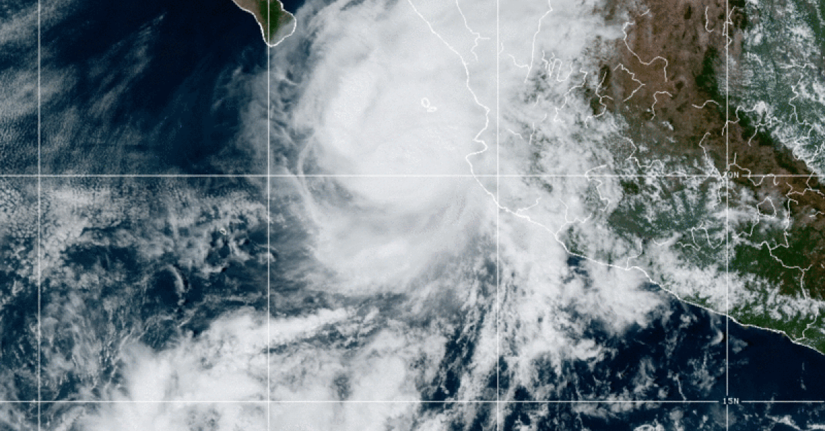
Hurricane Orlene; A small but major hurricane that was no match for Puerto Vallarta

We went to bed with a tropical storm on Friday and woke up to a category 4 hurricane threatening the coast of Jalisco, by Monday morning we had only experienced light scattered rains and minimal increase in waves with a forecast of winds of 2 km per hour in the early daylight hours. In fact, I am seeing the sun peaking through the cloudiness at this moment.

The hype of the storm along the coast of Jalisco by NOAA (the US weather agency) and Conagua (the Mexico weather agency) didn’t play out, although, even at this time (8:00 AM, Monday morning) Puerto Vallarta remains under a hurricane watch hours after Orlene has passed Jalisco.

On Sunday, Jalisco announced the closing of schools on Monday and the Puerto Vallarta International Airport announced a closure from 9 PM on Sunday until 8 AM Monday. The announcement of government building closures in Puerto Vallarta was also made on Sunday.

Although come Sunday night, people were strolling the Malecón in Puerto Vallarta and vendors were out selling their goods, as if they either didn’t get the Hurricane Watch memo, or they knew Orlene was no match for Puerto Vallarta.

Hurricane Orlene was a small compacted storm that only generated Hurricane and Tropical Storm conditions 150 km from its center (90 miles), not much larger than the Bay of Banderas. Its small size spared Puerto Vallarta from most of its effects due to the fact that the major, but small hurricane, stayed just slightly more than 150 km from shore, the distance of its reach.

While I don’t want to minimize the strength and destruction that Orlene might cause as it’s approaching landfall 400 km to the north, we can safely report that Puerto Vallarta was spared the worse thought, and Orlene never fulfilled her forecasts in our area.

As two more storms are taking shape off the Pacific coast of Mexico, we should never make the assumption that all forecasts are wrong or that Puerto Vallarta’s mountains and Bay will always protect us. Every warning should be taken seriously.

History will always remember Hurricane Kenna

Hurricane Kenna was the fourth-most intense tropical cyclone on record in the Eastern Pacific basin, and at the time the third-most intense Pacific hurricane to strike the west coast of Mexico.

Kenna was the sixteenth tropical depression, thirteenth tropical storm, seventh hurricane, sixth major hurricane, and third Category 5 hurricane of the 2002 Pacific hurricane season.

After forming on October 22 to the south of Mexico from a tropical wave, forecasters consistently predicted the storm to strengthen much less than it actually did.

Moving into an area of favorable upper-level conditions and warm sea surface temperatures, Kenna quickly strengthened to reach peak winds of 165 mph (270 km/h) as a Category 5 hurricane, on October 25, while located about 255 mi (410 km) southwest of Puerto Vallarta, Jalisco.

Weakening as it turned to the northeast, the hurricane made landfall near San Blas, Nayarit as a Category 4 hurricane, with sustained winds of 140 mph (220 km/h), before dissipating on October 26 over the Sierra Madre Occidental mountains.

The track of Kenna is very similar to this past weekend’s Hurricane Orlene, but Orlene didn’t hold the same strength and size as Kenna.

Hurricane Kenna – Puerto Vallarta 2002

The name “Kenna” was retired from the list of Pacific hurricane names due to its effects on Mexico, which included US$101 million in damage and four deaths.

The worst of the hurricane’s effects occurred between San Blas in Nayarit and Puerto Vallarta in Jalisco, where over 100 people were injured and thousands of homes and businesses were damaged or destroyed. 95% of the buildings in San Blas were damaged, and hundreds of buildings were destroyed along the coastal areas of Puerto Vallarta.

Hurricane Nora 2021

For those not around for Hurricane Kenna in 2002, we have a more recent example left by Hurricane Nora on August 29, 2021 to remind us that Puerto Vallarta still remains susceptible to hurricanes and all warnings should be taken seriously.

Hurrican Nora 2021

Noral wasn’t a very strong storm, it remained a category 1, and it didn’t make landfall in Puerto Vallarta, but it caused floods in several neighborhoods, structural damage to buildings and bridges, and the disappearance of two people in Puerto Vallarta, Jalisco.

In the downtown area of Puerto Vallarta there were about 12 blocks with damage due to the overflow of the Cuale River, among these effects are the collapse of the old bridge of the southern entrance to the city; the partial fall of a hotel with the loss of the life of a minor whose body has already been rescued; the dragging of a vehicle with a person on board who is still in search with the support of the Navy, damage to the Río Cuale market, as well as the collapse of a part of Manantial Street, which is the access to neighborhoods such as Buenos Aires, Paso Ancho, Paso del Guayabo and other rural communities.

The strong current of water in the river caused the collapse of the iconic La Surtidora del Puente building, which now serves as a small hotel, that was on the banks of the river and on Insurgentes Avenue in the Emiliano Zapata neighborhood.

Severe weather alerts are intended to protect people. So why do some ignore them?

The obvious reason is that so many times the bark is far worse than the bite when it comes to weather predictions and the issuance of warnings to the public, so the population almost certainly sees the threat much less than what they are being warned, which is exactly the cast for Hurricane Orlene in Puerto Vallarta this weekend. But that doesn’t mean you should start ignoring whether alerts because sometimes the bite is actually worse.

Watching interviews from victims of Hurricane Ian in Florida last week, it struck me how many of the people said ‘We didn’t think it was going to be this bad’, although the news for days prior had been reporting a dire situation.

According to accuweather.com, in a time where technology and meteorology are very precise, psychologists and meteorologists are working together to evaluate better warning systems.

Dr. Laura Myers, director and senior research scientist at the Center for Advanced Public Safety, who studied warnings and how people react to them, said people have a tendency to not want to change plans or their behavior for weather unless they are fairly sure the weather is going to impact them.

Myers said people get desensitized to watches and warnings after so many don’t produce any impacts for their specific area.

“Improvements in the warning process are addressing these issues and providing more specific geolocations and more lead time when possible,” Myers said.

Alert notifications that are targeted to an exact location and provide more lead time to help people react better. Also, warnings with potential impacts and calls to actions help people better respond to threatening weather.

“When people hear what the weather impacts are, such as damage and destruction to well-built homes, they start to pay attention. When they are told they need to take shelter now because their location is going to take a direct impact, they usually act,” Myers said.

The word emergency, such as a tornado emergency or flash flood emergency, tends to get the attention of people, Myers said.

The time a warning is issued to the public can also make a difference in response. When people are given too much lead time, they can get tired of waiting and tend to go back to their business, Myers said.

“That’s why we have to be careful giving too much information several days out from an event. There is a real communication process involved in the sequencing of information in the days and hours leading up to an event,” Myers said.

Regardless of the warning, some people wait until they see their life is in danger.

“A lot of social media research was done and people said they have to see [a tornado] before they do something,” AccuWeather Meteorologist Dan Kottlowski said.

Mike Smith, Senior Vice President of AccuWeather Enterprise Solutions and author of Warnings: The True Story of How Science Tamed the Weather, said there are many reasons why people wait to react.

“There is considerable inertia in people. They are busy or their attention is on some project. There is also sociological evidence that people feel silly for taking shelter; that it somehow reflects poorly on their courage,” Smith said.

He said in order to get people to take shelter or evacuate, it seems warnings need to come from someone they trust. Receiving the warning from more than one source can also help, Smith said.

“We try to issue the warnings very early now so they take cover, but people need to see that something’s coming at them,” Kottlowski said.

Therefore, Kottlowski said they have started enhanced warnings, which are warnings with amplified wording like severe and imminent danger.

“Not all warnings have enhanced wording, it’s only when we have a situation when we have a big tornado already causing damage,” Kottlowski said.

Meteorologists and psychologists are looking at more than just the wording.

“Psychologists are working with meteorologists to come up with an understanding of why people are just not adhering to the warnings, maybe it’s a combination of wording and graphics,“ Kottlowski said.

Kottlowski said radars don’t make sense to some people, so there needs to be a simple graphic that will show were the most dangerous impacts of the severe weather will occur.

However, broadcasters are able to explain radars to people in a simple, urgent manner.

“The really good television meteorologists have mastered the art of using tone of voice and other cues to persuade people to take action when they are convinced a really dangerous storm is occurring or imminent,” Smith said.

That will still not solve the problem entirely, experts agree.

“When you get a really bad outbreak where you have multiple tornadoes moving very quickly, you are still going to have a lot of fatalities and injuries because people aren’t going to be able to get out quickly enough,” Kottlowski said.

Technology, meteorologists and psychologists are making immense improvements and progress to help save the lives of people across the globe.

“The goal is to communicate weather information to an educated public who knows what to do when the time comes,” Myers said.

We went to bed with a tropical storm on Friday and woke up to a category 4 hurricane threatening the coast of Jalisco, by . . .

Follow Us On Google News | Get Our Newsletter


Trending News on PVDN

  • tropical-storm-erick-warnings-mexico-coastHurricane Erick will bring heavy rains to Puerto Vallarta Hurricane Erick Puerto Vallarta will bring heavy rains to Puerto Vallarta by Friday but poses no risk to the northern coast of Jalisco. Meteorologist Víctor Manuel Cornejo López, of the Civil Protection scientific committee for the Bay, reports that Hurricane Erick will deliver significant rainfall to Puerto Vallarta without threatening the region’s safety. According to…
  • sargassum-slams-cancun-playa-restaurantsSargassum Crisis in Cancún and Playa del Carmen Forces Restaurants and Beach Clubs to Cut Staff Businesses in Cancún and Playa del Carmen report steep losses due to sargassum, with restaurants losing diners and beach clubs sending staff on unpaid leave. Restaurants and beach clubs along the shores of Puerto Juárez in Cancún and Playa del Carmen are grappling with a sharp downturn in business due to a relentless invasion of…
  • huracan-erick-2025-mexico-peligroHurricane Erick Becomes Eastern Pacific’s Strongest Cyclone of 2025, Eyes Mexico’s Southwest Coast Hurricane Erick rapidly intensified off Mexico’s Pacific coast, becoming the second hurricane of the 2025 season and threatening southwestern Mexico with dangerous wind, rain, and storm surge. This story is available in Spanish: El huracán Erick se fortalece rápidamente y amenaza la costa suroeste de México The 2025 eastern Pacific hurricane season continues to surge…
  • tropical-storm-erick-hurricane-watch-southern-mexicoTropical Storm Erick Strengthening as Hurricane Watch Issued for Southern Mexico Tropical Storm Erick is forecast to become a hurricane before making landfall in southern Mexico. A Hurricane Watch is now in effect from Bahias de Huatulco to Punta Maldonado. Tropical Storm Erick continues to gather strength off Mexico’s southern Pacific coast and is forecast to become a hurricane by Wednesday, according to the latest advisory…
  • tropical-storm-erick-oaxaca-hurricane-warningTropical Storm Erick Threatens Oaxaca as Mexico Activates Civil Protection Plan Mexico activates a civil protection plan as Tropical Storm Erick strengthens. The storm may become a Category 2 hurricane, putting 22 municipalities in Oaxaca at risk. The Government of Mexico has activated its civil protection plan as Tropical Storm Erick moves closer to the country's southern Pacific coast, with Oaxaca, Chiapas, and Guerrero under direct…
  • Know your consumer rights in Mexico Is it legal for restaurants to include the tipPuerto Vallarta restaurants face 33 percent staff shortage Restaurants in Puerto Vallarta face a 33% staffing shortfall as they prepare for a busy summer holiday season, aiming to boost sales by up to 60% despite ongoing labor challenges. As Puerto Vallarta prepares to welcome a surge of summer tourists, the city’s restaurant sector is grappling with a serious staffing problem—operating with roughly one-third…
  • hurricane erick damagePuerto Escondido and Pinotepa Nacional suffer severe damage from Hurricane Erick (VIDEO) Hurricane Erick caused widespread destruction in Oaxaca's coastal towns, including Puerto Escondido and Pinotepa Nacional, with downed power lines, flooding, and road closures. Oaxaca’s southern coast is reeling after Hurricane Erick made landfall early Thursday morning, slamming into Santiago Pinotepa Nacional at 5:30 a.m. with maximum sustained winds of 205 kilometers per hour. Although the…
  • puerto-vallarta-flooding-first-storm-2025Puerto Vallarta hit by flooding, fallen trees, and damaged roads after first storm of the season Heavy rain and a nighttime storm caused widespread flooding, road closures, and downed trees in Puerto Vallarta. Several key roads remain impassable. PUERTO VALLARTA — The first major storm of the rainy season swept through Puerto Vallarta overnight, leaving behind extensive damage across the city, including widespread flooding, blocked roads, and fallen trees. By morning,…
  • tropical-cyclone-mexico-pacific-june-2025New Tropical Cyclone Likely to Form Off Mexico’s Pacific Coast This Week Meteorologists warn of a 90% chance a new tropical cyclone will form midweek off Mexico’s Pacific coast, as Dalila weakens and rains persist across southern Mexico. As Tropical Storm Dalila moves farther out to sea and becomes post-tropical, meteorologists are turning their attention to a new disturbance brewing off Mexico’s Pacific coast, which is highly…
  • american-woman-drowns-santa-maria-los-cabosAmerican Woman Drowns at Closed Beach in Los Cabos Despite Black Flag Warning A 57-year-old American woman drowned at Santa María Beach in Los Cabos, Baja California Sur, on June 17, despite black flag warnings indicating the beach was closed due to dangerous conditions. Los Cabos, Baja California Sur – Tragedy struck the beaches of Los Cabos on the afternoon of June 17, when a 57-year-old American woman…
Scroll to Top