Puerto Vallarta and Mexico News

Puerto Vallarta and Mexico News

NASA Data Shows Mexico City Sinking Faster Than Expected

NASA Data Shows Mexico City Sinking Faster Than Expected

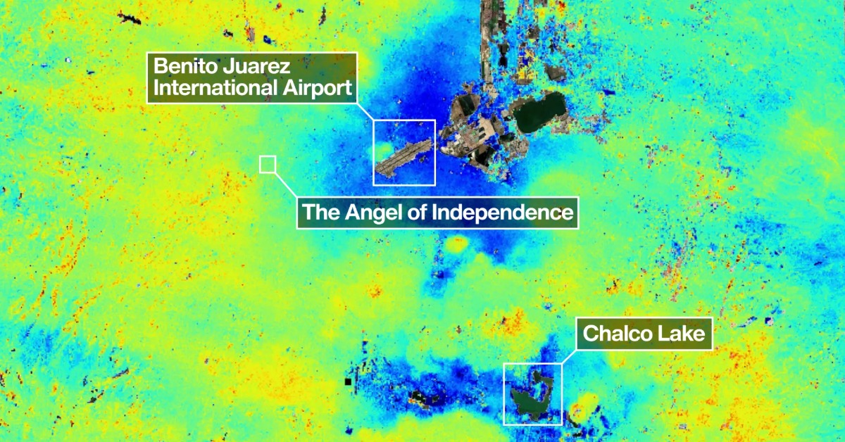
New satellite measurements are putting fresh numbers on a problem Mexico City has lived with for generations. NASA’s NISAR mission found areas of the capital sinking more than two centimeters per month, a rate that can quietly reshape roads, water lines, homes, and drainage systems. The new map does not mean the whole city is dropping at the same speed. It shows something more difficult for planners: uneven movement beneath one of the world’s largest urban areas.

NASA’s new view of a sinking capital

New satellite data from NASA is giving Mexico City a sharper look at a problem that has been building under the capital for more than a century. The measurements show that some areas of the city and its surrounding region are sinking by more than two centimeters per month.

The findings come from NISAR, a satellite mission developed by NASA and the Indian Space Research Organization. The satellite uses radar to track small changes in Earth’s surface, even when clouds, darkness, or vegetation would block normal optical images.

The new analysis is based on preliminary measurements taken between October 25, 2025, and January 17, 2026. Those months fall during Mexico City’s dry season, when groundwater demand and soil conditions are closely watched.

NASA’s map shows the problem is not uniform. Some areas are sinking much faster than others. That uneven movement is one reason land subsidence can damage buildings, streets, water lines, drainage systems, and public transit.

How Mexico City became so vulnerable

Mexico City sits in the Valley of Mexico, much of it built on the bed of ancient lakes. The Aztec capital of Tenochtitlan was founded on islands and wetlands. Over centuries, the lake system was drained as the colonial and modern city expanded.

That history left the capital on soft clay and lakebed sediments. These layers can compress when water is removed from the ground. The process is slow, but the damage becomes visible over time.

The main driver is groundwater pumping. Mexico City depends heavily on underground water to supply homes, businesses, and industry. When that water is removed, the old lakebed compacts. Once that compaction happens, much of the lost elevation cannot simply bounce back.

The weight of urban development adds to the pressure. Roads, homes, high-rises, airports, Metro lines, and water systems all sit on ground that is not equally stable.

This is not a new discovery. Engineers and researchers have documented sinking in Mexico City for decades. What is new is the level of detail and speed of satellite monitoring now available.

What the new satellite data shows

The NISAR image highlights areas where the ground is moving downward fastest. NASA says some of the darkest areas on the map show sinking of more than half an inch, or more than two centimeters, per month.

That rate is not the average for every neighborhood. It points to specific areas where the ground is dropping faster than the surrounding zones. The difference between one area and the next is often more damaging than the sinking itself.

The image includes the area around Benito Juárez International Airport and shows Lake Nabor Carrillo to the northeast. These references help place the map within the broader metropolitan region.

NASA also noted a familiar symbol of the city’s sinking ground: the Angel of Independence on Paseo de la Reforma. The monument was built in 1910, but the land around it has dropped over time. Additional steps have been added to its base as the surrounding ground level has changed.

The example is often used because it makes an underground process visible. Most damage from subsidence is less symbolic and more practical. It appears in cracked pavement, tilted streets, broken pipes, and drainage failures.

The risk is uneven ground, not one dramatic collapse

For many residents and visitors, the phrase “Mexico City is sinking” can sound like one single event. The reality is more complex.

The city is not falling into a hole. Instead, different parts of the metropolitan area are settling at different speeds. That creates stress where faster-sinking zones meet more stable ground.

This uneven sinking can bend rail lines, tilt roads, crack walls, and change the slope of drainage systems. In a city already exposed to heavy rains, flooding, and aging infrastructure, small changes in elevation can create larger problems.

The Metro system is one area of concern. Scientific work using radar data has found that subsidence and differential ground movement can affect tracks, slopes, columns, and other structures. This does not mean every affected segment is unsafe. It does mean maintenance planning needs detailed ground-movement data.

Water infrastructure is also exposed. Pipes are built for certain slopes and pressures. When the ground moves unevenly, those systems can fracture or lose efficiency. Drainage can also become less reliable when the land no longer slopes the way engineers intended.

For property owners, the concern is usually local. One neighborhood may face cracked sidewalks and waterline breaks. Another may see fewer visible effects. The new data helps narrow the question from “Is Mexico City sinking?” to “Which areas are moving fastest?”

Water remains at the center of the problem

Mexico City’s sinking is closely tied to its water model. The capital draws large amounts of water from underground sources while also importing water from outside systems. At the same time, many neighborhoods still experience shortages, rationing, or uneven service.

This creates a difficult cycle. The city needs water for daily life. But pumping too much from the aquifer contributes to ground compaction. The more the ground compacts, the harder it becomes to protect infrastructure built above it.

Rainwater capture, leak repair, aquifer recharge, and better water reuse are often discussed as part of the long-term response. None is a quick fix on its own. The scale of the city and the age of its infrastructure make the issue hard to solve.

The NISAR data does not provide a water policy. It provides a clearer measurement of the consequences. That matters because city planning often depends on knowing where the risks are increasing fastest.

What this means for residents, travelers and planning

For people living in Mexico City, the new data does not mean daily life changes overnight. The capital has lived with subsidence for generations. Flights, transit, housing, and business continue across the metro area.

But the measurements add pressure to a long-running planning challenge. Housing policy, infrastructure repairs, drainage upgrades, and airport operations all depend on stable ground assumptions. In some areas, those assumptions need constant updating.

For foreigners living in Mexico or traveling through the capital, the story is not a reason to avoid the city. It is a reminder that Mexico City’s water and infrastructure problems are deeply connected. Flooding, road repairs, Metro disruptions, and water service issues can all be part of the same underlying stress.

The new satellite monitoring gives authorities and researchers a more precise tool. It can help identify where repairs should be prioritized and where new projects may need stronger engineering standards.

A clearer warning, not a sudden surprise

NASA’s findings do not reveal a brand-new problem. They confirm, with sharper tools, that Mexico City’s ground is still moving at rates that can affect urban life.

The strongest message is not that the entire city is sinking at the same speed. It is that parts of the metropolitan area are sinking fast enough to reshape infrastructure planning.

For a capital of more than 20 million people, that has practical consequences. Roads, homes, pipes, train lines, and drainage systems need to be designed for a city whose ground is still changing.

The new data gives Mexico City a clearer map of that movement. The harder question is how quickly public policy, water management, and infrastructure investment can respond.

Related Posts

CJNG Recruiter Arrested as Michoacán Violence Persists

CJNG Recruiter Arrested as Michoacán Violence Persists

Authorities say “Comandante Giro” recruited people for crimes and homicides in Michoacán, where cartel pressure...
Vallarta weighs beach access plan to keep shores public

Puerto Vallarta Redraws Its Federal Beach Zone

Puerto Vallarta updated federal beach-zone maps to clarify concessions, reduce disputes and improve ZOFEMAT fee...
Fibra Macquarie Bidding War Tests Mexico Property Boom

Fibra Macquarie Bidding War Tests Mexico Property Boom

Competing bids for Fibra Macquarie show how warehouses, logistics and nearshoring are lifting Mexico’s industrial...

Puerto Vallarta Braces for Jalisco’s Hottest Day

Jalisco warns Thursday may bring the worst heat, with Puerto Vallarta’s coast under alert for...