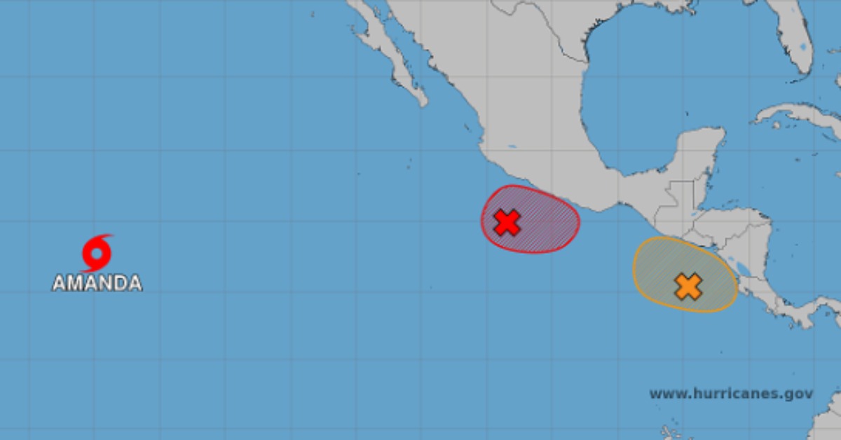
The Pacific is starting the season with more than one thing to watch. Amanda is drifting far out at sea, but two newer systems closer to Mexico are now getting attention from forecasters. It sits off the southern and southwestern parts of Mexico. Another is near Central America. Neither is a Puerto Vallarta storm today, but the early pattern is the kind that can change quickly along Mexico’s coast, especially when rain, swell, and port conditions begin moving before a named storm does.
Two Pacific Storms Are Brewing Near Mexico’s Coast
Puerto Vallarta should not read this weekend’s Pacific storm activity as a landfall forecast. That would go too far. It should be understood as an early-season watch that has become more active.
The NOAA discussion that first flagged the setup described two developing areas along the monsoon trough. One was off southern Mexico. The other was off Central America. The latest Eastern Pacific Tropical Weather Outlook has since raised the numbers for the system closest to Mexico’s coast.
That system, known for now as EP91, sits a few hundred miles southwest of Zihuatanejo. Forecasters say a tropical depression is likely to form Sunday or early next week. The system is expected to move generally northward near southern Mexico’s coast. The formation odds are now 70 percent within 48 hours and 70 percent through seven days. “Interests in southern Mexico should monitor the progress of this system,” the outlook says.
The next two names on the 2026 Eastern Pacific list are Boris and Cristina. Names are assigned only after a system reaches tropical storm strength. At this stage, EP91 is still a developing low, not a named storm.
What Puerto Vallarta should watch first
No official warning places Puerto Vallarta in the path of a tropical cyclone right now. The better signal is rain, swell, and coastal advisories moving north from the southern coast. That becomes more important if the system organizes and tracks close to land.
The Tropical Weather Discussion says EP91 could strengthen southwest to west winds over the offshore waters of southern Mexico by late Sunday or early Monday. Those winds could reach strong-to-near-gale force, with very rough seas from a large southwest swell.
The next few updates should be checked for any shift toward Colima, Jalisco, Nayarit, or Cabo Corrientes. Tropical weather along Mexico’s Pacific coast often becomes a water story before it becomes a wind story.
Amanda is not the local concern
Tropical Storm Amanda is still active, but it is far out in the Pacific and moving away from Mexico. The National Hurricane Center had Amanda at 12.7 degrees north and 134.7 degrees west late Friday night Hawaii time. It was moving southwest at about 5 mph, with maximum sustained winds near 40 mph.
Amanda is expected to weaken into a tropical depression by Saturday evening. It is forecast to become a remnant low by Sunday. That keeps it away from the coast, even though it remains part of the larger early-season pattern.
The second low near Central America
A second low-pressure area off Central America is also trying to organize. It is producing disorganized showers and thunderstorms. Forecasters give it a 50 percent chance of formation within 48 hours and 60 percent through seven days, if it stays offshore long enough.
That system is expected to bring heavy rain across parts of Costa Rica, Nicaragua, El Salvador, and Guatemala through early next week. It is not a Puerto Vallarta system now. Still, it adds to a broader monsoon pattern from Central America to southern Mexico.
The tropical weather discussion says southerly monsoon winds east of 110 degrees west are expected to strengthen this weekend and continue into early next week. The same outlook keeps possible tropical cyclone formation in view off southern Mexico and Central America.
Mexico has already shifted into response mode
Mexico’s weather agency and Conagua were already monitoring two low-pressure areas in the Pacific on Friday morning. At 6 a.m. Central Time, the systems were located near Lázaro Cárdenas, Michoacán, and southeast of the mouth of the Suchiate River, near the Mexico-Guatemala border.
By Saturday morning, a Conagua update described the southern Mexico system as having 70 percent odds of formation within 48 hours. The Guatemala and El Salvador systems stood at 50 percent. That is a fast change in a short window. It is why the weekend updates deserve more attention than the usual rainy-season glance.
In Huatulco, the National Civil Protection Coordination established the first command post for the 2026 rainy and cyclone season with the Oaxaca authorities. Oaxaca Gov. Salomón Jara said, “Nuestra prioridad es proteger la vida y el patrimonio de las y los oaxaqueños. Cada acción preventiva representa vidas salvadas.”
The Huatulco meeting included federal and state agencies, Conagua, the Federal Electricity Commission, and municipal leaders from the Oaxaca coast. Officials urged people in the affected region to follow official bulletins, clear drains, secure loose roofing and outdoor items, and avoid crossing rivers, arroyos, or flooded roads.
What changes the forecast for Puerto Vallarta
The forecast begins to change locally if EP91 bends farther northwest. Another signal would be rain expanding toward Colima and Jalisco. A stronger swell in Banderas Bay would also raise attention. So would any Conagua rain statement that starts naming the Jalisco coast. Those are the concerns to watch through about June 20.
Earlier season coverage warned that Mexico’s Pacific coast entered 2026 with an active backdrop, warm water, and elevated cyclone expectations. A separate Puerto Vallarta hurricane season guide also noted that the city’s storm problems often come from water first. That means swollen rivers, loose hillsides, flooded streets, waves, and port closures.