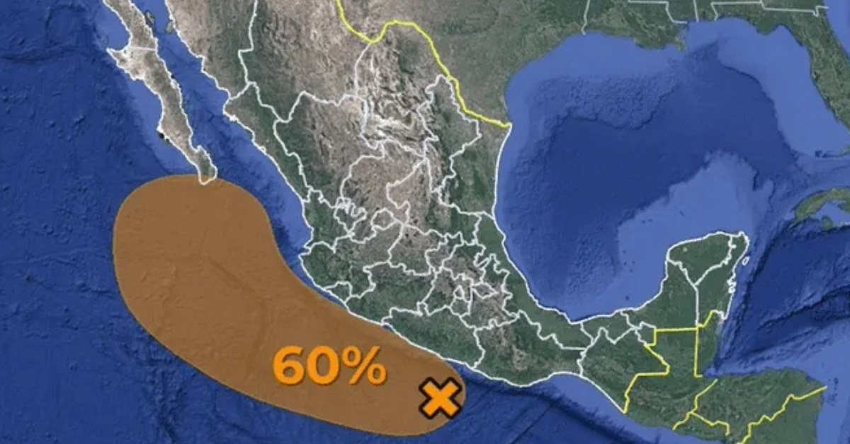
Puerto Vallarta, Jalisco — A potential tropical cyclone is expected to move along the coast of Jalisco in the coming days, according to the National Meteorological Service (SMN), the official climate source for the Mexican government. As Tropical Wave No. 21 continues to move across the center, south, and west of Mexico, a low-pressure system forming off the coast of Guerrero is predicted to intensify, bringing heavy rainfall and strong winds to several states, including Guerrero, Michoacán, Colima, and Jalisco.
SMN has reported that the low-pressure zone, which currently has a 10% chance of cyclonic development within 48 hours and a 60% chance over the next seven days, is located 185 kilometers southwest of Punta Maldonado, Guerrero. The system is gradually moving north-northwest and could pose a significant weather threat as it approaches the Mexican coastline.
Impending Rainfall and Storm Activity
As Tropical Wave No. 21 moves slowly across southern and central Mexico, its effects are already being felt in regions such as Guerrero, Michoacán, and Jalisco, where intense rainfall is forecasted. By Wednesday, this tropical wave is expected to combine with the low-pressure system off the Pacific coast, further intensifying storm activity across western and southern parts of the country. Heavy rains, accompanied by electrical discharges, are anticipated, along with the possibility of hail in certain areas.
The SMN warns that coastal states, particularly Guerrero, Michoacán, Colima, and Jalisco, should brace for heavy to very heavy rainfall in the coming days. This weather pattern could lead to flash flooding, rising river levels, and landslides in vulnerable areas, particularly in rural and mountainous regions.
Tropical Cyclone Could Form by Thursday
According to current forecasts, the Pacific low-pressure system is expected to develop into a tropical cyclone by Thursday. As the system strengthens, it will likely move off the coasts of Jalisco and Nayarit, bringing with it very strong gusts of wind, high waves, and the potential for waterspouts. Coastal regions in Colima, Jalisco, Nayarit, Sinaloa, and Baja California Sur are expected to experience the brunt of the storm’s effects.
By Friday, the tropical system is expected to approach Baja California Sur, bringing torrential rains to the region. Residents of these coastal areas, as well as those living in the Gulf of California, should be prepared for strong winds, heavy rains, and the possibility of further intensification.
Potential Impacts on Puerto Vallarta
As the storm moves closer to Jalisco, Puerto Vallarta and surrounding coastal communities are at risk of experiencing severe weather. Local authorities are urging residents to stay informed and prepare for potential impacts. Heavy rainfall, flash floods, and strong winds could disrupt daily activities and cause damage to infrastructure. Additionally, fishermen and coastal businesses are being advised to take precautions as high waves and dangerous sea conditions are expected.
While the exact path of the tropical system remains uncertain, the SMN is closely monitoring its development and will issue further advisories as the situation evolves. Residents and visitors along the Pacific coast are encouraged to stay updated on weather forecasts and heed the warnings of local authorities.
Hurricane “Francine” Moves Away
In the meantime, Hurricane “Francine,” which had previously raised concerns for the region, is now moving away from Mexico’s coastline and is expected to make landfall in the southeastern United States. This hurricane no longer poses a threat to Mexico, but the Pacific low-pressure system remains a key focus for forecasters as it continues to intensify.
Safety Recommendations for Residents and Visitors
As storm conditions develop, the SMN and local authorities recommend that residents and visitors in affected areas take the following precautions:
- Stay Informed: Regularly check updates from the National Meteorological Service and local authorities for the latest information on storm development and emergency advisories.
- Prepare for Flooding: Those in low-lying areas should be prepared for possible flooding. Ensure that drainage systems are clear, and have emergency supplies, including food, water, and medicine, on hand.
- Avoid Travel in Storm-Affected Areas: Coastal and rural roads may become impassable due to landslides or flooding. If possible, avoid non-essential travel during heavy rainfall and storm conditions.
- Secure Outdoor Items: Strong winds can cause damage by moving loose objects. Secure outdoor furniture, tools, and other items that could become dangerous projectiles during high winds.
- Follow Evacuation Orders: In the event of an emergency, be prepared to follow evacuation orders promptly. Know the location of emergency shelters and have a plan in place for your family and pets.
Conclusion
With the possibility of a tropical cyclone forming off the coast of Jalisco, residents of Puerto Vallarta and the surrounding coastal regions should prepare for potentially dangerous weather in the coming days. The National Meteorological Service will continue to monitor the system and provide updates as conditions change. For now, the priority remains ensuring public safety and minimizing the impact of the storm on vulnerable communities.
This is a press release by weather services in Mexico for distribution to citizens of Mexico.
Puerto Vallarta, Jalisco — A potential tropical cyclone is expected to move along the coast of Jalisco in the coming days, according to the National Meteorological Service (SMN), the official climate source for the Mexican government. As Tropical Wave No. 21 continues to move across the center, south, and west of Mexico, a low-pressure system forming off the coast of Guerrero is predicted to intensify, bringing heavy rainfall and strong winds to several states, including Guerrero, Michoacán, Colima, and Jalisco.