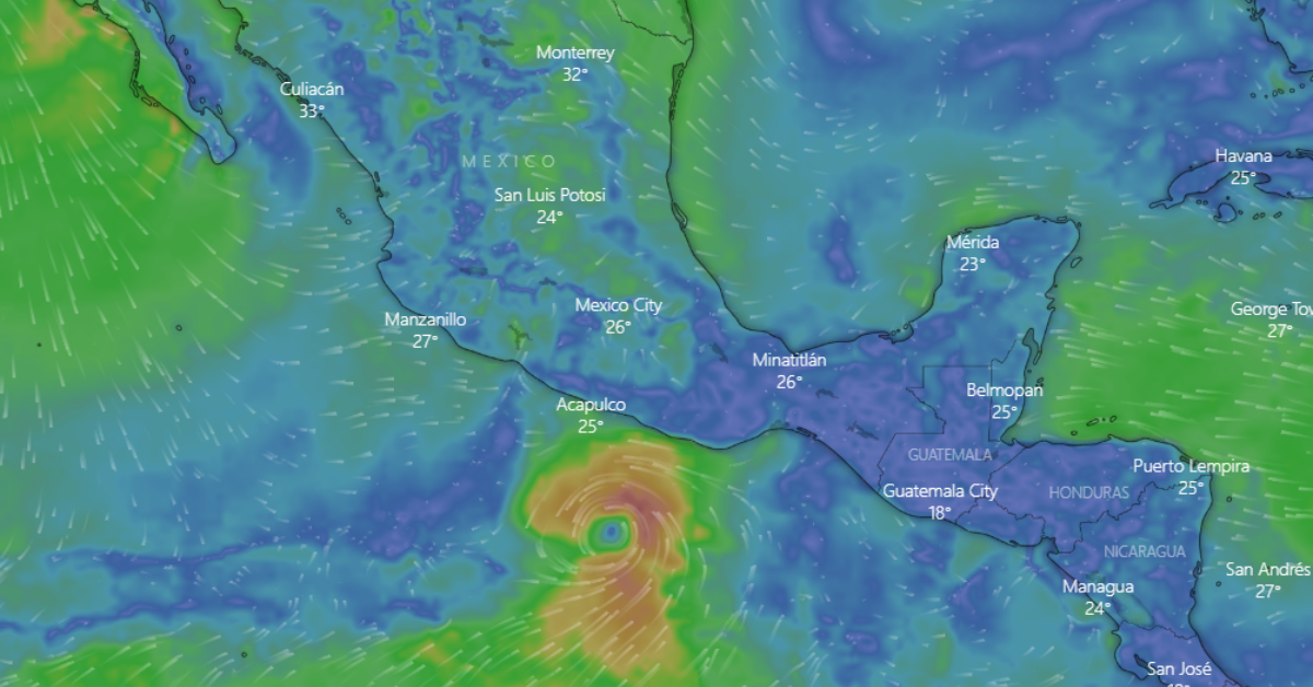
The National Water Commission ( Conagua ) reported this Saturday afternoon that tropical storm Agatha, the first of the 2022 Pacific Hurricane Season, continues to gradually strengthen in the Pacific area.
Through a statement, it detailed that until 4:00 p.m., it was located approximately 270 kilometers southwest of Puerto Ángel, in the state of Oaxaca, registering maximum sustained winds of 95 kilometers per hour (km / h) with gusts of 110 km/h and displacement to the north-northwest at 7 km/h.
For the next few hours, the forecast of intense punctual rains (from 75 to 150 millimeters [mm]) in places in Chiapas, Guerrero, Oaxaca, and Tabasco, and very strong (from 50 to 75 mm) in the south of Veracruz. Also, high waves are expected, from 2 to 4 meters high, in the coastal strip of Guerrero and Oaxaca.
Due to the above, the State Civil Protection Coordination of Oaxaca (CEPCO) activated preventive measures in Puerto Ángel, Huatulco, and Puerto Escondido, where they were closed to navigation.
In Puerto Escondido, fishermen and nautical service providers from the main beach sheltered their boats in a safe area, in addition to placing sandbags in the lower parts of the creek to prevent overflow.
The National Meteorological Service ( SMN ) in coordination with the National Hurricane Center, establishes a prevention zone for hurricane effects from Salina Cruz to Lagunas de Chacahua, Oaxaca; hurricane watch zone from Salina Cruz, Oaxaca, to Barra de Tonalá, Chiapas, and tropical storm prevention zone from Lagunas de Chacahua, Oaxaca, to Punta Maldonado, Guerrero, and from Salina Cruz, Oaxaca to Boca de Pijijiapan, Chiapas.

Precipitation could generate landslides, an increase in the levels of rivers and streams, and overflows and floods in low-lying areas in the south and southeast of Mexico, for which the population is urged to heed the warnings from the SMN and Conagua, as well as to follow the indications of the state, municipal and Civil Protection authorities.
Agatha is expected to turn north towards the state of Oaxaca, intensifying to a category 1 hurricane during the early hours of Sunday, and could possibly reach category 2 before making landfall.
The recommendations of the CNPC are very of great importance so that the inhabitants of the indicated area avoid any type of risk and are the following:
- Clean roofs and drains to prevent flooding.
- Identify the closest temporary shelter.
- Be attentive to weather information channels
A few weeks ago, the SMN predicted the formation of up to 40 storms in the remainder of 2022, both in the Atlantic and in the Pacific, of which five could impact Mexican territory as a hurricane.
Germán Martínez Santoyo, general director of Conagua, stressed that although rains and cyclones can cause damage, they also make life possible because they allow us to capture water to minimize the effects of drought, as well as for human consumption and agricultural activities.
“It is in the rainy season when the arid or semi-arid zones have the opportunity to recharge the level of their dams and their aquifers, as well as to favor the development of rainfed crops,” he explained.
The National Water Commission ( Conagua ) reported this Saturday afternoon that tropical storm Agatha, the first . . .