Puerto Vallarta, Mexico – Tropical Storm Alvin is unraveling quickly along the eastern Pacific, with the latest reconnaissance and satellite data showing a rapidly weakening system. Overnight scatterometer passes placed the storm’s center near the southern edge of its coldest cloud tops, prompting meteorologists to trim its sustained winds to 45 kt (52 mph). Alvin is now moving north-northwest at 9 kt (10 mph), and it is on track to turn more directly north within the next 24 hours as it approaches a weakness in the subtropical ridge.
Alvin’s environment has grown increasingly hostile. Analysis from the Cooperative Institute for Meteorological Satellite Studies at the University of Wisconsin (CIMSS-UW) indicates that the storm has entered a zone of strong vertical wind shear. That shear is displacing convection away from the low-level center, robbing Alvin of its heat engine. At the same time, cooler sea surface temperatures along its projected path will further sap the storm’s strength. Forecasters expect Alvin to lose its tropical characteristics and degenerate into a post-tropical remnant low by this weekend.
Despite the weakening trend, Alvin remains a concern for mariners and any coastal interests. Tropical-storm-force winds still extend outward up to 70 miles from the center, and rough seas will spread northward along the forecast track. Swells generated by Alvin are already hitting parts of the Mexican Pacific coast, raising the risk of localized rip currents and beach erosion. Small-craft advisories are in effect for waters north of the storm’s center, and officials urge seafarers to remain clear of the system until it loses tropical characteristics.
The official National Hurricane Center (NHC) forecast nudges Alvin’s peak intensity down slightly relative to previous runs, but it remains in line with consensus model guidance. Alvin should maintain 45 kt winds through the next six hours or so before a steady decline begins. By 24 hours from now, sustained winds are expected to fall below 35 kt, at which point the system will be reclassified as a remnant low. If that occurs on schedule, Alvin will be the first tropical system of the 2025 eastern Pacific season to “spin down” rather than intensify.
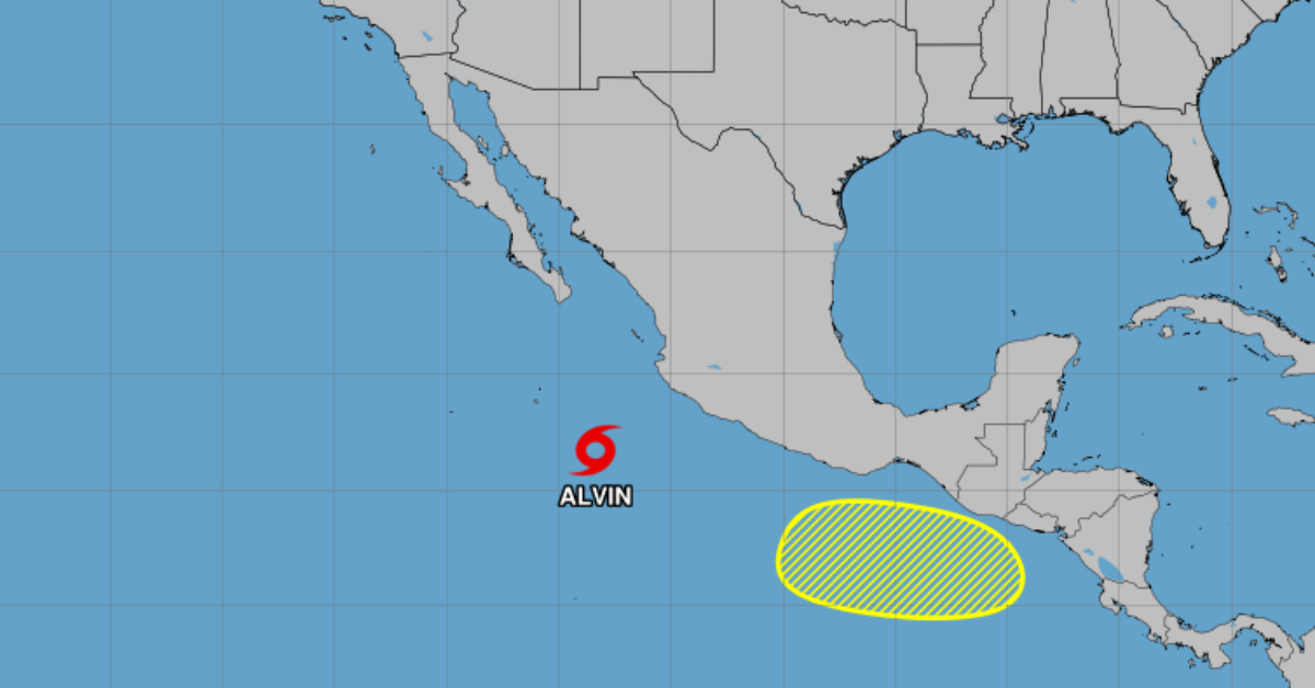
Behind Alvin, meteorologists are eyeing a second area of low pressure that may develop by mid-week off the coasts of Central America and southern Mexico. Currently, environmental conditions in that region are only marginally supportive of tropical cyclone formation. Dry air and moderate shear should keep any early development in check. The NHC gives this disturbance a near-zero percent chance of forming within the next 48 hours. However, by seven days from now, the formation probability climbs to 20 percent as the system drifts west-northwest at roughly 10 to 15 mph.
Should the low-pressure area consolidate into a tropical depression or storm, its journey over even cooler waters and under continued shear will likely mirror Alvin’s fate. Still, forecasters will monitor the system closely, since even a weak tropical cyclone can generate dangerous surf and rainfall along shorelines. Mariners, fishers, and coastal communities from southern Mexico through parts of Central America should keep abreast of updates over the coming days.
Residents in the Baja California Sur region need not take immediate action, as no tropical watches or warnings are in effect at this time. Nonetheless, local authorities advise people to remain aware of changing weather conditions, particularly those planning boating or beach activities. The upcoming trough moving into northern Mexico may interact with Alvin’s remnants over the weekend, bringing scattered showers and gusty winds to inland communities.
Looking ahead, the eastern Pacific basin remains primed for further activity as the seasonal peak approaches in July and August. Sea surface temperatures have already warmed to near-record levels in some areas, and the Madden–Julian Oscillation may steer more tropical waves westward from Africa in the coming weeks. While Alvin peaked modestly, its rapid decay illustrates how shear and cooler waters can shut down nascent storms quickly. Forecasters caution that the atmospheric balance can shift, allowing future systems to find more favorable environments and intensify.
For now, Tropical Storm Alvin is on the brink of transitioning to a post-tropical remnant by this weekend. Follow the National Hurricane Center’s advisories for the latest track and intensity forecasts, and monitor local marine statements for surf and rip-current updates. Meanwhile, keep an eye on the developing low-pressure area off Central America—it could become the next named system in the eastern Pacific.
Puerto Vallarta, Mexico - Tropical Storm Alvin is unraveling quickly along the eastern Pacific, with the latest reconnaissance and satellite data showing a rapidly weakening system. Overnight scatterometer passes placed the storm’s center near the southern edge of its coldest cloud tops, prompting meteorologists to trim its sustained winds to 45 kt (52 mph). Alvin is now moving north-northwest at 9 kt (10 mph), and it is on track to turn more directly north within the next 24 hours as it approaches a weakness in the subtropical ridge.
")


