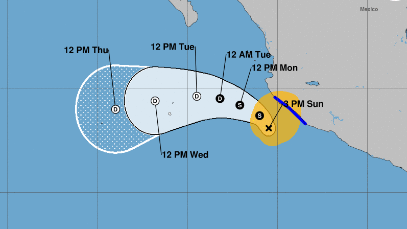
Tropical Storm Xavier is moving toward the north near 6 mph (9 km/h). A turn toward the northwest and west-northwest at a similar forward speed is expected tonight and on Monday, followed by a westward motion by Tuesday.
On the forecast track, Xavier’s center is expected to remain offshore the coast of southwestern Mexico and begin to move farther away from the coast Sunday night and on Monday.
A Tropical Storm Warning is in effect for Punta San Telmo, Jalisco to Playa Perula, Michoacán. The storm could bring rains and higher than normal surf to Puerto Vallarta, but tropical storm levels will not extend into the Puerto Vallarta area.
Maximum sustained winds are near 50 mph (85 km/h) with higher gusts. Weakening is forecast during the next few days, and Xavier is expected to degenerate into a remnant low by Tuesday.
Tropical-storm-force winds extend outward up to 150 miles (240 km) from the center.
The estimated minimum central pressure is 1001 mb (29.56 inches).
HAZARDS AFFECTING LAND
———————-
RAINFALL: Xavier is expected to produce total rain accumulations of 1 to 3 inches over coastal sections of the Mexican states of Guerrero, Michoacan, Colima, and Jalisco through Monday. Isolated maximum amounts of 4 inches are possible over Michoacan and Colima. This rainfall may produce flooding.
WIND: Tropical storm conditions are expected within the warning area through early Monday.
SURF: Swells generated by Xavier will affect portions of the coast of southwestern Mexico during the next few days. These swells are likely to cause life-threatening surf and rip current conditions. Please consult products from your local weather office.
Tropical Storm Xavier is moving toward the north near 6 mph (9 km/h). A turn toward the northwest and west-northwest at a similar . . .


