Puerto Vallarta, Mexico – NOAA monitoring two potential storms off Mexico with high chances of forming tropical storms Pacific coast Mexico this week.
Forecasters with the National Oceanic and Atmospheric Administration (NOAA) are keeping a close watch on two distinct areas of low pressure brewing in the Pacific Ocean off the coast of southern Mexico. Both systems have the potential to develop into tropical storms over the next week. If the first system organizes into a storm, it will carry the name Barbara. The second system, if it achieves tropical storm status, will be known as Cosme.
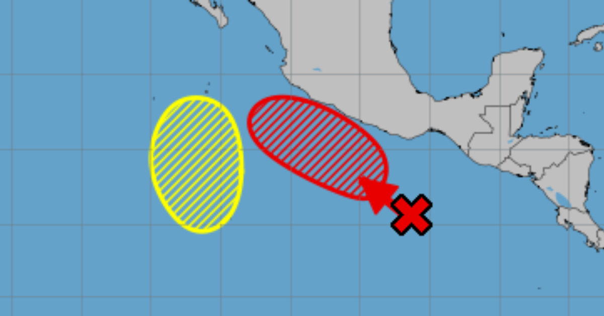
System One: Potential Tropical Storm Barbara
The first area of disturbed weather lies several hundred miles south of southern Mexico. This system, which forms on the eastern side of an elongated trough, is likely to become more organized over the coming days. According to NOAA, environmental conditions appear favorable for development, with warm sea surface temperatures and low wind shear supporting storm formation.
- Formation chance through 48 hours: Medium (40 percent)
- Formation chance through 7 days: High (80 percent)
NOAA forecasts indicate a tropical depression could form on the weekend and gain strength as it moves generally west-northwestward. If the system meets tropical storm criteria—sustained winds of at least 39 miles per hour—it will receive the name Barbara. The 80 percent chance of formation over seven days places this disturbance among the more likely candidates to watch during this part of the hurricane season.
State and local authorities along Mexico’s Pacific coast are already preparing for the possibility of heavy rain, gusty winds, and elevated surf conditions. While the storm is expected to remain offshore, it could still generate swells and coastal impacts. Fishermen and small-boat operators are advised to monitor updates closely and avoid venturing into open water if NOAA issues tropical storm watches or warnings. Tourists in coastal resort areas should also stay alert for potential storm advisories and ocean conditions that might affect beach activities.
System Two: Possible Tropical Storm Cosme
A second area of low pressure is forecast to take shape on the western side of the same elongated trough south of Mexico. This system has less immediate potential for development but could organize slowly over the weekend. NOAA’s outlook shows:
- Formation chance through 48 hours: Low (near 0 percent)
- Formation chance through 7 days: Low (30 percent)
Although the short-term chances are minimal, forecasters acknowledge that environmental conditions may improve enough to allow some gradual organization. Should this system strengthen into a tropical storm, it would be named Cosme. Given its lower probability compared to the first disturbance, Cosme remains a secondary concern. Still, residents and mariners should stay informed because even a weaker tropical depression can produce heavy rainfall and localized flooding.
June marks the early phase of the Eastern Pacific hurricane season, which officially runs from May 15 through November 30. It is not uncommon to see early-season storms forming off the Mexican coast. In recent years, storms like Agatha (2022) and Blanca (2021) formed in June and brought significant rainfall to coastal and inland areas of southern Mexico. These events typically prompt regional authorities to issue flood watches and warnings, and to prepare evacuation plans in vulnerable low-lying communities.
Local emergency management agencies are coordinating with NOAA’s Tropical Prediction Center to refine forecasts and mobilize resources. Residents in Oaxaca, Chiapas, Guerrero, and Michoacán are advised to review their hurricane preparedness plans, secure loose outdoor items, and ensure that drainage channels remain clear. Officials stress that even storms that remain offshore can cause hazardous rip currents, flash flooding, and mudslides in mountainous terrain.
Meteorologists expect that if Barbara forms, it will track away from the coast, reducing direct landfall risk. However, large swells and heavy rains could still reach coastal communities. In areas where the terrain is steep, rainfall rates of 3 to 6 inches over a short period can trigger dangerous mudslides. Residents should monitor local media and official channels for updates.
For Cosme, the lower likelihood of formation does not eliminate all risks. Forecasters note that any organization into a tropical depression would still warrant attention. Those living along the coast should keep an eye on the horizon, sign up for text or email alerts from local authorities, and have an emergency kit ready that includes water, nonperishable food, flashlights, batteries, and important documents.
NOAA’s next scheduled outlook for these systems will refine probabilities and likely include more details on possible storm tracks. As always, forecasters will update the public as new data arrives from weather reconnaissance flights, satellite imagery, and computer model forecasts. Mariners should consult the U.S. National Weather Service Marine Forecasts before heading out, and coastal communities should prepare for potential impacts as the weekend approaches.
In summary, NOAA’s analysis suggests an 80 percent chance that the first area of low pressure will become Tropical Storm Barbara within the next week, while the second area holds only a 30 percent chance of forming Tropical Storm Cosme. Residents along Mexico’s Pacific coast should stay informed, review preparedness measures, and heed official guidance as these systems evolve.
Puerto Vallarta, Mexico - NOAA monitoring two potential storms off Mexico with high chances of forming tropical storms Pacific . . .


