The Fujiwhara effect Pacific storms could alter the paths of Barbara and Cosme, raising coastal risks for Mexico’s Pacific states this week.
The National Meteorological Service (SMN) has identified two developing low‐pressure systems in the Pacific Ocean that could grow into tropical storms named Barbara and Cosme. Their close proximity raises the possibility of a Fujiwhara effect, a rare interaction that can alter storm tracks and intensity along Mexico’s Pacific coast.
Two Potential Storms Form in the Pacific
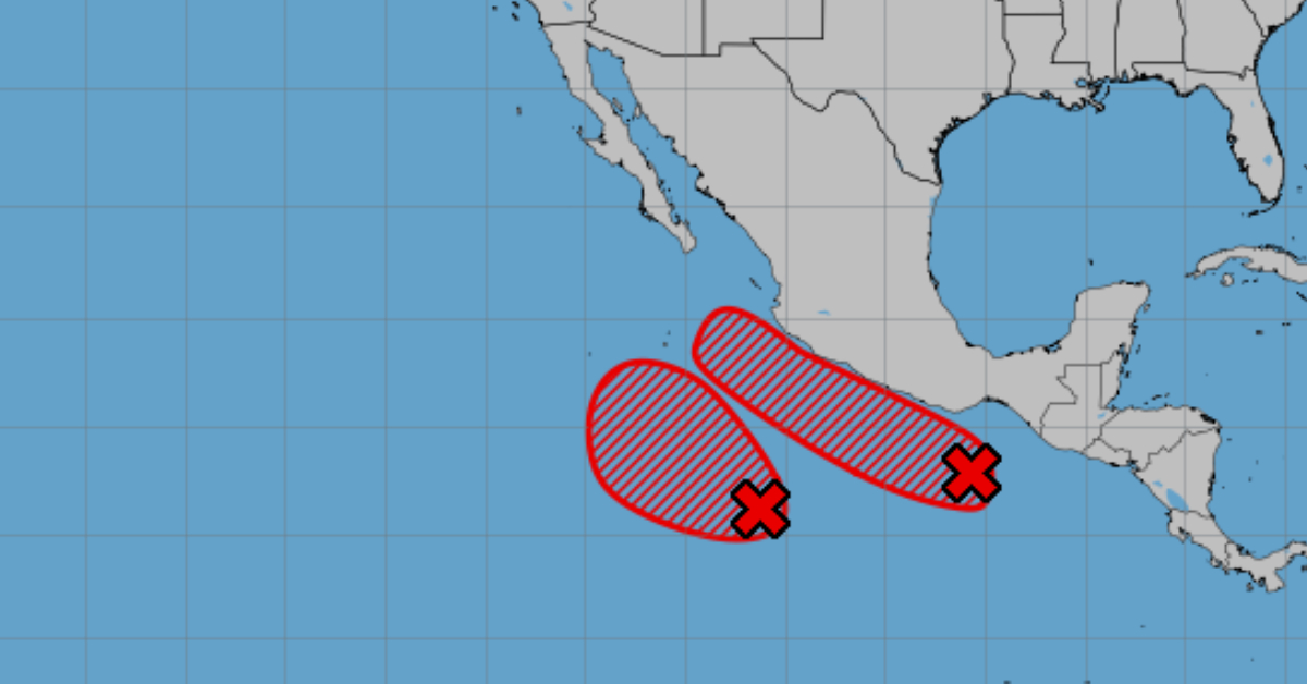
Early this week, SMN forecasters spotted a low‐pressure area about 575 kilometers south of Bahías de Huatulco, Oaxaca. The system holds a 50 percent chance of strengthening into a tropical cyclone within 48 hours and an 70 percent chance over the next seven days. It is moving west‐northwest at about 15 kilometers per hour. If it reaches tropical storm status, it will be named Barbara and could develop further as it approaches waters off Guerrero and Michoacán this weekend.
Meanwhile, Mexico’s National Water Commission (CONAGUA) reported a second low‐pressure area roughly 830 kilometers south of Punta San Telmo, Michoacán. This disturbance carries a 50 percent chance of cyclone formation in the next two days and a 80 percent chance during the next week. If it intensifies into a tropical storm, it will take the name Cosme. Its current trajectory points westward over open waters.
Understanding the Fujiwhara Effect
When two tropical cyclones come within approximately 1,200 kilometers of each other, they can engage in what meteorologists call the Fujiwhara effect. In this scenario, each storm begins to rotate around a common center. If both systems share similar strength, they will orbit around a midpoint between them. If one storm grows stronger than the other, the dominant system can pull the weaker one into its circulation or even absorb it entirely.
Forecasters say that if Barbara and Cosme form as projected and stay within range, their interaction could produce unexpected shifts in direction. That outcome would complicate predictions for coastal areas of Guerrero, Michoacán, Colima, and Jalisco, where increased rainfall and higher sea swells could pose hazards. Communities in these states should monitor official advisories in case either storm changes course or combines impacts due to the Fujiwhara effect.
Pacific Hurricane Season Outlook
Mexico’s 2025 Pacific hurricane season officially began on May 15. Tropical Storm Alvin emerged as the first named system on May 20, forming roughly 585 kilometers south‐southwest of Punta San Telmo. Alvin moved north‐northwest before dissipating without making landfall.
Meteorologists now expect between 16 and 20 cyclonic systems in the Eastern Pacific this season. Of those, 8 to 9 are likely to reach tropical storm strength. Between 4 and 5 could escalate into Category 1 or 2 hurricanes, while 4 to 6 may intensify to Category 3 or higher. Should Barbara and Cosme both develop, they would count among these totals and could influence each other’s paths if they remain close.
Advisories and Preparedness
Mexico’s National Civil Protection Coordination urged residents in coastal states to stay informed through official channels. Local authorities will issue watches and warnings as needed. Fishing boats and small‐craft operators should heed marine advisories, and beachfront communities should prepare for possible high waves and heavy rainfall beginning this weekend.
Citizens can follow updates from SMN and CONAGUA on social media or their official websites. Emergency response teams stand ready to support evacuations or relief efforts if winds, flooding, or storm surges threaten populated areas.
As Barbara and Cosme develop, their potential Fujiwhara effect could reshape typical storm behavior. Residents from Oaxaca to Jalisco should review hurricane preparedness plans, stock basic supplies, and remain alert to changing conditions.
The Fujiwhara effect Pacific storms could alter the paths of Barbara and Cosme, raising coastal risks for Mexico’s Pacific states this . . .


