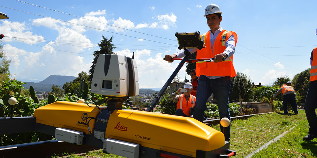
The Consorcio IUYET team used a Leica SiTrack reality capture system to obtain point clouds of the surroundings and sub-millimetric railhead measurements. Courtesy Consorcio IUYET. Like most major cities, Mexico City has a traffic problem. But the logjams that cause headaches in other metro areas cause blitzing migraines in Mexico’s capital, where the traffic crisis ranks as the world’s worst . Commutes in Mexico City take an average of 66% longer because of congestion. During rush hours, that figure rises to 96–101%. For drivers, that means 59 extra minutes in traffic . . .
CONTINUE READING THIS NEWS ARTICLE BY BECOMING A PVDN SUBSCRIBER!
>> SUBSCRIBE TO OUR NEWS ON WHATSAPP CHANNELS HERE (FROM YOUR CELL PHONE!)<<
Popular posts:
 Citizens of Puerto Vallarta Still Feel Safe Putting The City in Seventh Place in the Country Puerto Vallarta, Jalisco, continues to shine as one of Mexico's safest cities, securing its position among the nation's top 10 cities where citizens feel most secure, according to the latest National Urban Public Safety Survey (ENSU) conducted by INEGI. The survey, which evaluates citizen perceptions of safety, covers the first quarter of the year and…
 Unchecked Growth of Platforms Like Airbnb is Ruining Puerto Vallarta Puerto Vallarta, Mexico - In Puerto Vallarta, the proliferation of digital lodging platforms, notably Airbnb, has sparked a surge in real estate development over the past decade, particularly in central areas of the municipality. This trend, as highlighted by Alfonso Baños, a researcher and doctor in City, Territory, and Sustainability at the University of Guadalajara…
 Puerto Vallarta Gears Up for the 2024 Marathon Puerto Vallarta is abuzz with anticipation as it braces to host the fifth edition of its renowned Marathon, slated to kick off on April 21. This eagerly awaited sporting spectacle has firmly entrenched itself as a highlight on the global athletic calendar, drawing participants from diverse corners of the world. The 2024 Puerto Vallarta Marathon…
 FAKE NEWS ALERT: American Reported Missing in Puerto Vallarta Found After Four Hours, Not Four Years Recent false claims circulating online regarding an alleged four-year disappearance of an American in the jungles of Puerto Vallarta have been debunked. The individual was actually reported missing on April 9 and found a mere four hours later, highlighting the swift and efficient response of local authorities in safeguarding the community. This incident underscores the…
 Triple Arrival of Cruise Ships Brings Thousands of Tourists to Puerto Vallarta Puerto Vallarta, Mexico - On Tuesday, April 16th, Puerto Vallarta witnessed a bustling spectacle as three grand cruise ships made their way into its vibrant harbor, injecting the city with a surge of international tourists eager to explore this renowned beach destination. The trio of maritime giants included the Zaandam, gracefully docking at Pier 1,…
 Possible Case of Measles Under Investigation in Puerto Vallarta The Jalisco Health Secretariat is investigating a potential case of measles in Puerto Vallarta, though no confirmation has been made yet. Head of the eighth health region, Jaime Álvarez Zayas, revealed this development, emphasizing that while it's being treated as a febrile exanthematic illness, it has been forwarded for thorough analysis. Álvarez Zayas stated, "A…
 LGBTQ+ Travelers Contribute 40% of Puerto Vallarta’s Tourism Revenue Puerto Vallarta, Mexico - In a significant milestone for Puerto Vallarta, Jalisco, the influence of LGBT+ tourism on the city's economy soared to unprecedented heights in 2023. According to recent data released by Luis Antonio Villaseñor, the general director of the Puerto Vallarta Tourism Trust, the sector welcomed a record-breaking 2 million visitors, injecting a…
 Puerto Vallarta Welcomes Record-Breaking Cruise Visitors, Boosting Local Economy Puerto Vallarta, Mexico - Puerto Vallarta, known as the "green pearl of the Mexican Pacific," has marked an impressive start to the year, welcoming a staggering 177,000 passengers aboard 58 cruise ships during the first quarter. These figures, revealed by the Administration of the National Port System (ASIPONA), reflect a substantial economic injection of 21…
 Annual US Human Rights Report Denounces Mexico’s Impunity and Persistent Violence Puerto Vallarta, Mexico - In its latest Annual Human Rights Report, the United States Department of State has condemned Mexico for its failure to investigate and prosecute the majority of criminal cases, including homicides, torture, kidnappings, human trafficking, and extortion. The report, released recently, also underscored that the level of violence within the country remains…
 New Direct Flight from Prague to Puerto Vallarta Announced for Autumn-Winter Season In a move set to bolster international tourism to Puerto Vallarta, Jalisco, a new direct flight route from Europe has been unveiled, marking a significant expansion in the city's air connectivity. Beginning in October of this year and continuing through April 2025, travelers from the heart of Europe will have the opportunity to embark on…


