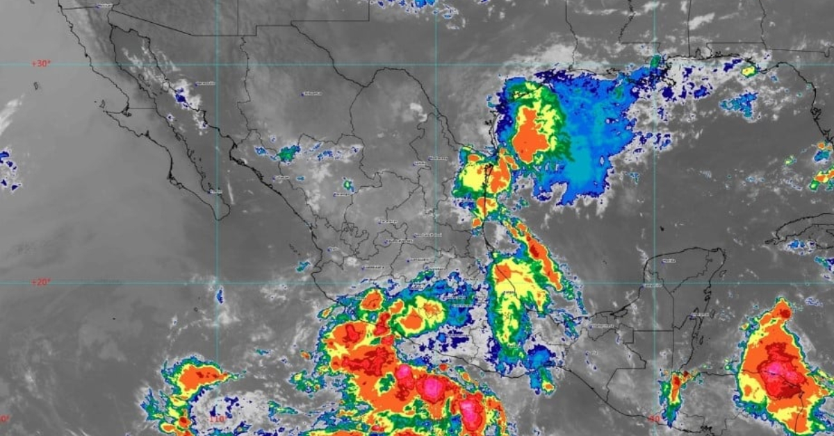
PUERTO VALLARTA (PVDN) – The National Meteorological Service (SMN) of the National Water Commission (Conagua) warns of a likely cyclone forming off the coasts of Jalisco and Colima due to the confluence of tropical wave number 9 and a zone of low pressure. This weather pattern is expected to induce substantial rains across the west of Mexico.
Tropical wave number 10, moving across the center and south of Mexico, will maintain conditions conducive to heavy, and at times severe, rains. This is coupled with an increased chance of electric shocks and possible hailstorms, affecting these regions and the Valley of Mexico.
In the northwest, center, and southeast of the country, low-pressure channels interacting with instability at high atmospheric levels and an influx of moisture from the Gulf of Mexico, Pacific Ocean, and the Caribbean Sea will result in heavy rains, electrical discharges, and potential hailstorms. Oaxaca and Chiapas are likely to be the most affected regions.
Despite the widespread rains, a sweltering environment will persist over the northwestern and northeastern states of Mexico. Temperatures above 45 degrees are anticipated in Baja California, and temperatures ranging from 35 to 45 degrees are expected in several other regions including Sonora, Chihuahua, and Nuevo León, among others. Cooler temperatures will be confined to mountainous areas of Baja California, Hidalgo, Puebla, and Tlaxcala.
The heavy rains risk escalating river and stream levels, leading to potential landslides and floods. This severe weather is also likely to induce gusty winds, with speeds reaching 40 to 60 km/h in Tabasco, Campeche, Yucatán, and Quintana Roo. Meanwhile, other regions including Baja California, Sonora, and Chihuahua could experience possible dust storms.
A regional breakdown of weather forecasts reveals:
- Valley of Mexico: Heavy rains are expected in Mexico City and the State of Mexico, with possible hail fall. River and stream levels may rise, increasing the risk of landslides and floods.
- Baja California Peninsula: Partially cloudy skies with isolated rains in areas of Baja California Sur and potential dust storms in Baja California.
- North Pacific: Partly cloudy skies with potential heavy rains, electric shocks, and hail fall. The risk of rising river and stream levels and ensuing landslides and floods remains.
- Central Pacific: Very heavy rains with possible hail fall expected in Michoacán, Colima, Jalisco, and Nayarit. Risks of landslides and floods are high.
- South Pacific: Very heavy rains, electric shocks, and potential hail fall anticipated in Guerrero, Oaxaca, and Chiapas.
- Gulf of Mexico: Heavy rains, electric shocks, and possible hail fall are expected in Tamaulipas, Tabasco, and Veracruz. Risks of landslides and floods are elevated.
- Yucatán Peninsula: Cloudy sky with intervals of showers and electric shocks.
- Mesa del Norte: Heavy rains in Durango, Chihuahua, and San Luis Potosí, with potential landslides and floods.
- Central Table: Very heavy rains in Puebla, heavy rains in Hidalgo, Morelos, and Tlaxcala, showers in Querétaro and Guanajuato.
Residents in affected areas are advised to stay alert to updates from local weather services and take appropriate measures to ensure safety in light of these extreme weather conditions.
PUERTO VALLARTA (PVDN) - The National Meteorological Service (SMN) of the National Water Commission (Conagua) warns of a likely cyclone forming off the coasts of . . .