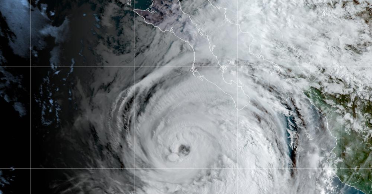
MEXICO CITY (AP) — Hurricane Kay steamed toward a possible brush with land on a sparsely populated stretch of Mexico’s Baja California Peninsula Thursday, and forecasters say it might bring rains to southernmost California by the weekend.
Authorities in Baja opened shelters and closed schools ahead of Kay, which had maximum sustained winds of 85 mph (140 kph).
Forecasters said it could bring hurricane-force winds to parts of the peninsula and brush central Baja on Thursday around the village of Punta Abreojos, near the gray whale sanctuary of El Vizcaino.
The U.S. National Hurricane Center in Miami said there is a chance the outer bands of the big storm could bring heavy rain — and possibly flash floods — to parts of scorched Southern California and southwestern Arizona on Friday night and Saturday.
The Hurricane Center said Kay was centered about 85 miles (135 kilometers) west of Cabo San Lazaro early Thursday. Kay was moving north-northwest, up and just offshore from the Baja coast, at 14 mph (22 kph).
A hurricane warning was issued for a sparsely populated stretch of the peninsula around Bahia Asuncion and Punta Abreojos and the state government of Baja California Sur said more than 1,600 people had evacuated to shelters. It said some creeks were rising and closed some roads.

Heavy rain fell on Los Cabos at the southern tip of the peninsula. Mayor Oscar Leggs Castro said Wednesday there were more than 800 people in shelters in the twin resort destinations.
Long lines of cars waited to fill up at gas stations. Nonessential businesses were closed and some airlines cancelled flights.
Landslides reportedly cut some roadways on the peninsula, but there were no reports of injuries.
Meanwhile, Hurricane Earl churned through open waters in the Atlantic Ocean and was forecast to pass just southeast of Bermuda on Thursday night as a major Category 3 storm.
The island’s national security minister, Michael Weeks, told reporters that public services and government offices would keep operating but warned residents to brace for tropical storm conditions.
“Bermuda will certainly feel the effects from Earl, so we must guard against complacency,” he said.
Earl was centered about 265 miles (425 kilometers) south of Bermuda early Thursday. Its maximum sustained winds had strengthened to 105 mph (165 kph) and it was moving north at 10 mph (16 kph).
Farther east, Danielle weakened to a tropical storm far out over open waters in the Atlantic some 660 miles (1,060 kilometers) north-northwest of the Azores. It had maximum sustained winds of 70 mph (110 kph).
MEXICO CITY (AP) — Hurricane Kay steamed toward a possible brush with land on a sparsely populated stretch of Mexico’s Baja California Peninsula Thursday . . .