Puerto Vallarta, Mexico – The weather authorities have announced the formation of a new tropical cyclone off the southwestern coast of Mexico, which has shown significant convective organization over the past few hours. This system, located a few hundred miles from the Mexican coast, is rapidly developing and has now reached the criteria to be classified as a tropical cyclone.
Satellite Observations and Cyclone Formation
Recent first-light visible imagery from a GOES-West meso-sector has captured the development of organized curve banding in the storm. The low-level cloud motions, observed through satellite data, indicate the presence of closed cyclonic flow, confirming the cyclone’s formation. This improved convective structure was also seen in an earlier 1040 UTC SSMIS microwave pass. Additionally, the latest subjective Dvorak intensity estimates from both the Satellite Analysis Branch (SAB) and the Tropical Analysis and Forecast Branch (TAFB) have recorded a T2.5/35 kt intensity for the system.
Initial Advisory and Intensity
Based on these observations, advisories have been initiated for this newly formed tropical cyclone. The initial intensity for this advisory is set at 30 kt, slightly below the Dvorak estimates due to lower objective estimates and earlier scatterometer data. This initial advisory marks the system as a developing threat, prompting closer monitoring and preparedness measures.
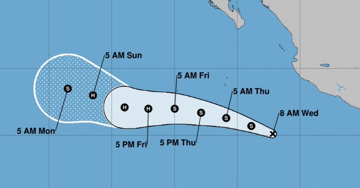
Forecast Track and Motion
The initial estimated motion of the cyclone is towards the west-northwest at 295/12 kt. This movement is expected to continue with a slight turn more westward in the coming days as the system becomes primarily steered by a deep-layer ridge over the southwestern United States. Towards the end of the forecast period, there could be a weakening of this ridge on its western extent, potentially allowing the system to turn more poleward.
The initial track forecast adheres closely to the consensus aids TVCE and HCCA, which predict a trajectory between the operational GFS and ECMWF tracks, slightly favoring the latter. This forecast aims to provide a balanced outlook, considering the possible variances in the model predictions.
Intensity Forecast and Environmental Conditions
Regarding intensity, Tropical Depression 3-E (TD3-E) is expected to intensify over the weekend. The SHIPS guidance from both the GFS and ECMWF models suggest that the shear will remain low (less than 15 kt), while the sea-surface temperatures underneath the cyclone will stay within the 29-30°C range over the next few days. This favorable environment could lead to significant intensification once an inner core becomes established.
Interestingly, the regional hurricane model guidance, while showing intensification, does not currently predict rapid intensification. The National Hurricane Center’s (NHC) first intensity forecast anticipates more gradual intensification over the next day or so, followed by a faster rate, potentially peaking the system as a Category 1 hurricane within 72 hours, on the higher end of the intensity guidance. Towards the end of the forecast, the tropical cyclone is expected to move over cooler ocean waters, leading to gradual weakening around day 4 or 5.
Preparedness and Advisory
Residents and authorities along the southwestern coast of Mexico are advised to stay alert and monitor updates from the National Hurricane Center and local weather services. The development of this tropical cyclone highlights the importance of preparedness and timely response to mitigate potential impacts.
Further updates will be provided as more data becomes available and the situation develops.
Puerto Vallarta, Mexico - The weather authorities have announced the formation of a new tropical cyclone off the southwestern coast of Mexico, which has shown significant convective organization over the past few hours. This system, located a few hundred miles from the Mexican coast, is rapidly developing and has now reached the criteria to be classified as a tropical cyclone.


")


