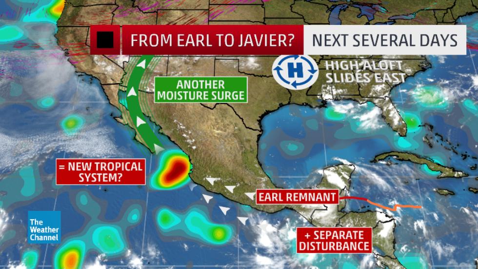
Earl’s surface circulation will continue to spin down and/or get ripped apart in southern Mexico, but its spin and moisture a few thousand feet above the surface may hold together.
Migrating westward, this remnant or “ghost” of Earl may eventually merge with another disturbance off southern Mexico’s Pacific coast to help generate another tropical cyclone by early next week.
As of Thursday, the National Hurricane Center said there was a high chance a new tropical cyclone could form early next week off Mexico’s Pacific coast.
Incidentally, since it wouldn’t be the same surface circulation, it wouldn’t keep the name “Earl.” Instead, it would be designated Tropical Depression Eleven-E, then gain the name “Javier” if it attains tropical storm strength (sustained winds of at least 39 mph).
With high pressure aloft sliding east and a rather sharp southward plunge of the jet stream over the western U.S., an alley may form allowing the tropical cyclone, if it forms, to track northwestward toward Mexico’s Baja Peninsula next week.
If you have vacation plans to, say, Los Cabos or Puerto Vallarta, this isn’t anything to worry about just yet, but it would be wise to monitor weather.com for the latest updates.
Regardless of whether a tropical cyclone does form in the eastern Pacific, a surge of moisture – some of which may be remaining from Earl – appears likely to push from Mexico into the Desert Southwest next week.
However, there is some uncertainty regarding the western U.S. jet stream that could serve to shunt that deep moisture a bit farther east.
Those under the moisture surge will see an enhancement in coverage of thunderstorms, with a threat of flash flooding.
How often does a “ghost” or remnant of a past tropical storm or hurricane help form a new one in a different basin?
According to NOAA’s Hurricane Research Division, it’s more common than it sounds.
It most recently occurred in October 2014 when eastern Pacific Tropical Storm Trudy made landfall in Mexico. After that, NOAA/HRD says the following occurred:
– Trudy’s circulation dissipated in the mountains of southern Mexico.
– The remnant moisture and spin aloft helped spawn a tropical depression in the Bay of Campeche.
– That depression weakened to a tropical low before moving over the Yucatan Peninsula.
– It regenerated into a depression, then Tropical Storm Hanna before landfalling near the Honduras/Nicaragua border.
It’s happened in the opposite direction, as well.
In 2001, Iris made a devastating landfall in southern Belize as a Category 4 hurricane after a less-than-five-day cruise through the Caribbean Sea, spun down to a remnant low, then was reborn as Tropical Storm Manuel in the eastern Pacific Ocean, lasting over a week in that basin.
NOAA-HRD documented 15 total cases of remnants of tropical storms or hurricanes from one basin helping to form new tropical storms or hurricanes in another basin, dating to 1923. They caution that due to lack of satellite data, some other cases prior to the 1970s may have gone undetected.
This has occurred 11 times since the 1970s, or once every 3 to 4 years, on average. One of these cases involved 1974’s Hurricane Fifi, responsible for anywhere from 3,000 to 10,000 deaths (primarily due to rainfall flooding) in Central America.
Another bizarre case involved a Category 5 landfall in Belize (Hurricane Hattie in 1961) whose remnant helped form eastern Pacific Tropical Storm Simone.
But there’s more.
Simone’s remnant then ended up back in the Bay of Campeche, merging with another disturbance to help form Tropical Storm Inga.
To recap, that was Atlantic to eastern Pacific back to Atlantic Basin.
You may wonder whether there’s any potential analog to what may happen with Earl’s remnant. Namely, has an eastern Pacific tropical cyclone spawned from an Atlantic remnant ever made landfall in Mexico?
Several have come close, but officially, it has only happened twice, according to NOAA-HRD:
– September 1974: Hurricane Orlene (seeded by Atlantic Hurricane Fifi)
– September 1971: Hurricane Olivia (made landfall in Baja California as a tropical depression; seeded by Atlantic Hurricane Irene)
Therefore, Earl’s remnant helping to spawn another tropical cyclone in another basin would be somewhat unusual. But if that new tropical cyclone then makes landfall, this string of events would be extremely rare.
About the Author:
Jonathan Erdman is a senior meteorologist at weather.com and has been an incurable weather geek since a tornado narrowly missed his childhood home in Wisconsin at age 7.
Earl's surface circulation will continue to spin down and/or get ripped apart in southern Mexico, but its spin and moisture a few thousand . . .


")


