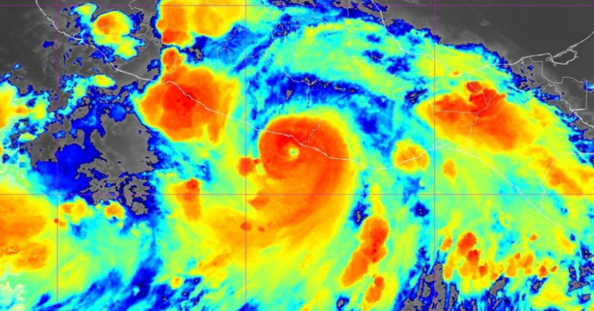
Puerto Vallarta, Mexico – As Hurricane John barrels toward the southern coast of Mexico, the National Weather Service has confirmed that the storm has intensified into a Category 3 hurricane. With landfall expected late tonight or in the early hours of Tuesday, September 24, the coastal regions of Oaxaca and Guerrero are bracing for severe weather conditions.
At 9:00 p.m. this evening, the storm’s center was located 20 kilometers west of Punta Maldonado and approximately 190 kilometers northwest of Puerto Escondido. Hurricane John’s maximum sustained winds have reached 195 kilometers per hour, classifying it as a powerful Category 3 storm on the Saffir-Simpson scale. The storm is moving at a speed of 13 kilometers per hour toward the north, a trajectory that positions it to bring heavy damage and extreme weather to both coastal and inland areas of southern Mexico.
Impacts on Oaxaca and Guerrero
Residents in Oaxaca and Guerrero are already experiencing heavy rainfall and coastal surges. Forecasters warn that the hurricane will bring torrential rains, with rainfall expected to peak at 335 millimeters in southwest Oaxaca and 461 millimeters in eastern Guerrero by Tuesday morning. Such heavy rainfall poses a serious risk of flash flooding and mudslides, particularly in areas near riverbeds and mountainous regions.
The Mexican government has issued hurricane alerts from Acapulco to Bahías de Huatulco, covering a wide range of communities at risk of both direct hurricane impact and secondary effects such as flooding and landslides. Civil Protection units in both states have activated emergency protocols, urging residents to heed official advice and evacuate to safer locations if necessary.
Preparation and Safety Recommendations
Given the intensity of Hurricane John, authorities have issued the following recommendations for those living in areas at risk:
- Avoid riverbeds and streams: Due to the likelihood of flash flooding and sudden overflows, residents are advised to stay away from riverbeds, streams, and other areas susceptible to water surge.
- Identify a shelter: If you live in a flood-prone area or an unsafe structure, it is crucial to locate a nearby shelter. Civil Protection units can provide information on the nearest temporary shelters, and you can also call 911 for assistance.
- Secure your home: Inspect your home for any potential vulnerabilities, particularly on roofs, windows, and walls. Make any necessary repairs to minimize the risk of further damage from strong winds and rain. Additionally, clear drains, gutters, and rooftops of debris to prevent blockages during heavy rain.
- Prune trees and secure loose objects: To reduce the risk of falling trees and other debris, residents should prune trees and shrubs around their homes. Objects such as television antennas, signs, and hanging items should be securely fastened or brought indoors to prevent them from becoming hazardous projectiles during the storm.
- Prepare an Emergency Backpack: Authorities recommend preparing an ‘Emergency Backpack’ containing essential items such as food, water, medications, and flashlights. Importantly, store copies of critical documents (such as identification, insurance policies, and property deeds) either in physical form or digitally by scanning them onto a USB drive or sending them to your own email account.
Emergency Services on High Alert
Mexican authorities have dispatched additional resources to the coastal regions, including personnel from the military and Civil Protection units, to assist with evacuations and rescue operations if necessary. Several temporary shelters have already been established in affected areas, and evacuation orders are in place for regions at the highest risk of flooding and landslides.
In Puerto Escondido and other popular tourist destinations, local authorities have closed beaches and advised residents and visitors alike to seek shelter indoors as the storm approaches. Air and sea transport in the region has been temporarily suspended to prevent accidents during the storm’s landfall.
As Hurricane John moves closer to the coast, residents of Oaxaca and Guerrero must remain vigilant and take all necessary precautions to protect themselves and their homes. The situation is developing rapidly, and authorities are urging people in high-risk zones to act quickly and follow evacuation orders if issued.
For up-to-the-minute updates, residents can monitor local news outlets, follow announcements from Civil Protection units, and stay in touch with family and friends. While the full impact of Hurricane John remains to be seen, preparedness and swift action will be essential in mitigating the storm’s potentially devastating effects.
Puerto Vallarta, Mexico - As Hurricane John barrels toward the southern coast of Mexico, the National Weather Service has confirmed that the storm has intensified into a Category 3 hurricane. With landfall expected late tonight or in the early hours of Tuesday, September 24, the coastal regions of Oaxaca and Guerrero are bracing for severe weather conditions.


