Puerto Vallarta (PVDN) – The Popocatepetl volcano in Mexico has reawakened this week, emitting massive ash clouds that prompted school cancellations in 11 villages and the temporary closure of Mexico City and Puebla Airports over the weekend.
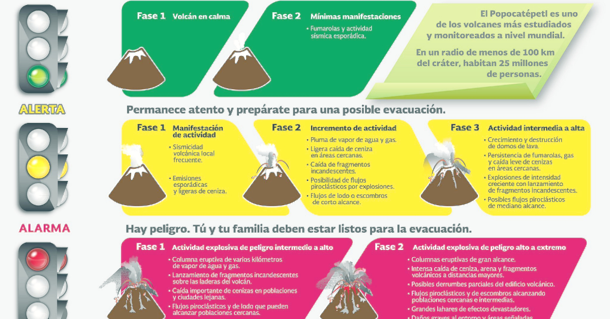
The National Coordination of Civil Protection reported today that the volcanic alert traffic light goes up from Yellow Phase 2 to Yellow Phase 3, due to the activity of Popocatépetl.
Its resurgence has not gone unnoticed. A plethora of scientists, an expansive network of sensors and cameras, along with a suite of high-tech equipment constantly monitor the volcano, affectionately known as “El Popo”. Since its reactivation in 1994 after a lengthy period of dormancy, the 5,426-meter (17,797-foot) high peak has been continuously emitting toxic fumes, ash, and incandescent rock.
Situated 72 kilometers southeast of Mexico City, the volcano poses a considerable threat to the city’s eastern outskirts and its 22 million residents. Although the city is also vulnerable to earthquakes and sinking soil, the potential danger from the volcano is the most prominent and continuously monitored. A severe eruption could disrupt air traffic and envelope the city in suffocating ash clouds.
A series of six cameras, a thermal imaging device, and 12 seismological monitoring stations, operating round the clock, are installed around its summit. All these devices relay information to a command center in Mexico City laden with state-of-the-art equipment.
The command center is staffed round the clock by a team of 13 multidisciplinary scientists who can alert residents of impending ash clouds, enabling them to take necessary precautions. Unlike earthquakes, warning times for volcanic activity can be lengthier and predictions more accurate.
Recently, researcher Paulino Alonso has been monitoring the readings at the command center, which is managed by Mexico’s National Disaster Prevention Center, known as Cenapred. This task includes studying seismographs to identify any internal tremors within the volcano that could suggest the upward movement of hot rock and gas.
Monitoring of nearby springs, peak gases, and wind patterns, which can predict the potential ash path, are also integral to the process. The internal forces can temporarily alter the volcano’s shape, so continuous monitoring of its form is also crucial.
To convey this complex phenomenon to the 25 million people residing within a 100-kilometer radius, authorities have developed a simple volcano “stoplight” system. It employs green, yellow, and red colors to indicate safety, alert, and danger levels, respectively.
The stoplight system has mostly indicated a “yellow phase 2” since its inception, suggesting regular periods of activity. While the volcano occasionally becomes dormant, it never remains so for an extended period. It seldom emits molten lava but frequently releases explosive bursts of gas, ash, and hot rocks.
This center also operates in other states, considering Mexico’s frequent encounters with natural disasters.
For instance, Mexico’s earthquake early alert system is housed at the same command center. Due to Mexico City’s soft soil foundation, which was once a lake bed, earthquakes even hundreds of miles away on the Pacific coast can cause extensive damage. As seen in 1985 and 2017, a network of seismic monitors along the coast sends out faster alerts than the earthquake’s shockwaves, providing city dwellers up to 30 seconds to find safety, usually in the open streets.
Laura Velásquez, head of the CNPC, explained that under the new warning level, the following risks can be expected:
- Light to moderate explosions that throw fragments into the crater environment
- Notorious rains of volcanic ash in surrounding towns and in some distant cities
- Significant growth of the dome and possibility of expulsion of magma
- Aviation risk
- Large explosions of increasing intensity that send fragments considerable distances
What Civil Protection activities are activated with the Phase 3 Yellow traffic light?
- Communicate the situation to the public and media
- Report on the preparation and mitigation measures for the increase in activity of the Popocatépetl Volcano
- Prepare personnel, evacuation teams and shelters
- Promote specific actions for the vulnerable population that may be affected
- Implement preventive actions against the fall of ash and fragments
- Alert air navigation systems
- Limit access to the Popocatépetl Volcano over an area larger than the current one (12 kilometers)
Velásquez informed that in view of this situation, the Scientific Advisory Committee of the Popocatépetl Volcano declares itself in permanent session.
Puerto Vallarta (PVDN) - The Popocatepetl volcano in Mexico has reawakened this week, emitting massive ash clouds that prompted school cancellations in 11 villages and the temporary closure of Mexico City and Puebla Airports over the weekend.
The National Coordination of Civil Protection reported today that the volcanic alert traffic light goes up from Yellow Phase 2 to Yellow Phase 3, due to the activity of Popocatépetl.
Its resurgence has not gone unnoticed. A plethora of scientists, an expansive network of sensors and cameras, along with a suite of high-tech equipment constantly monitor the volcano, affectionately known as "El Popo". Since its reactivation in 1994 after a lengthy period of dormancy, the 5,426-meter (17,797-foot) high peak has been continuously emitting toxic fumes, ash, and incandescent rock.


