The U.S. Air Force confirms a tropical depression has formed in the Bay of Campeche. Mexican authorities issue coastal warnings as the system nears tropical storm strength.
A tropical depression has officially formed in the Bay of Campeche, and Mexican authorities are warning coastal communities to prepare for the possibility of tropical storm conditions in the coming hours.
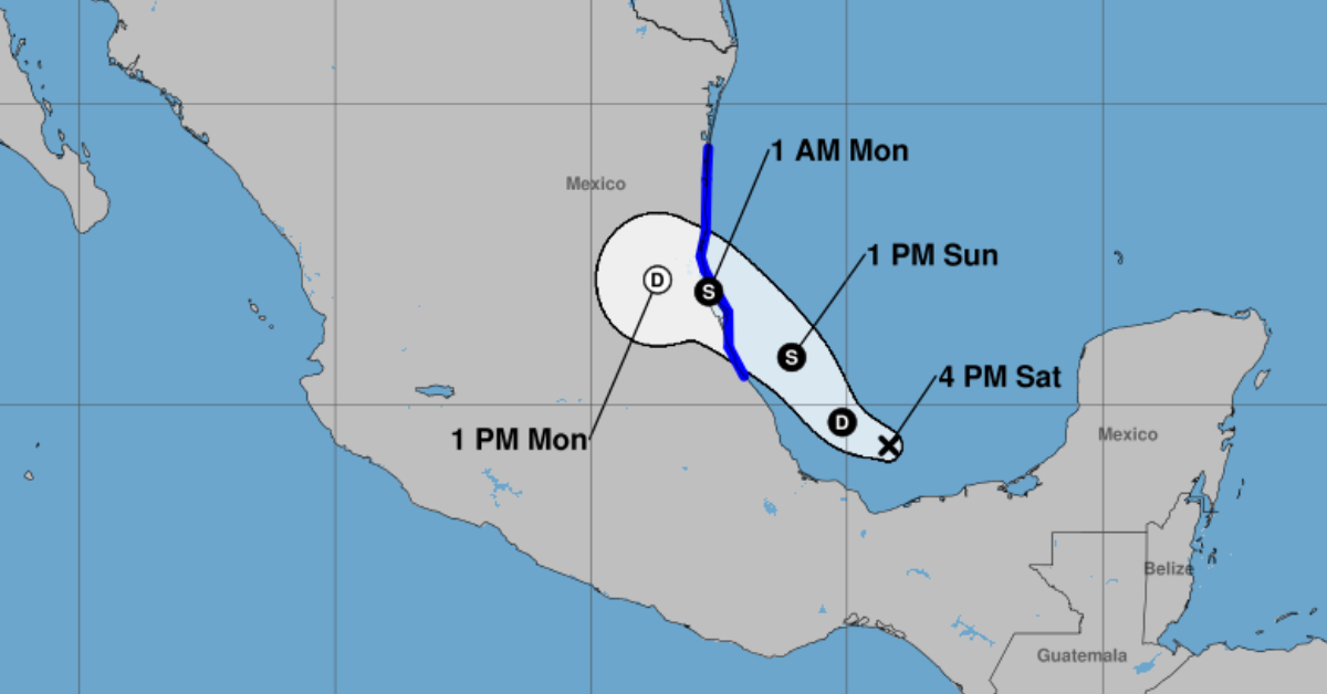
At 3:00 p.m. on Saturday, June 28, the United States Air Force’s 53rd Weather Reconnaissance Squadron, known as the Hurricane Hunters, confirmed that the disturbance designated as #91L had developed into a tropical depression. The aircraft, flying mission #AF304, collected data over the southern Gulf of Mexico and submitted a preliminary report identifying the formation of the depression.
This development marks the beginning of a new tropical system in a region historically known for breeding dangerous storms. The depression, still organizing its center of circulation over the Bay of Campeche, is expected to continue strengthening.
According to current forecasts, the system is likely to reach tropical storm intensity within the next 36 hours. If it intensifies as projected, it will be named Barry—the next designation on the official list of tropical cyclone names for the 2025 Atlantic hurricane season.
In response to the storm’s formation, the Mexican government has issued a coastal warning for a wide stretch of shoreline along the Gulf of Mexico. The warning zone currently spans from Boca de Catán in Tamaulipas to Tecolutla in Veracruz, an area that is particularly vulnerable to heavy rainfall, damaging winds, and flash flooding.
Although the center of the depression is not expected to make a direct impact on the state of Campeche, meteorological authorities say its outer bands could still bring adverse conditions to the area, including rain and high surf.
Mexico’s Civil Protection agency is urging residents in coastal and low-lying regions to monitor updates through official government channels. Authorities are recommending precautionary steps such as securing property, preparing emergency supplies, and being ready to evacuate if necessary.
“The Gulf Coast must stay alert. Systems that form in the Bay of Campeche can intensify rapidly and move inland quickly, giving little time for preparation,” said a spokesperson from the national Civil Protection department.
Historically, storms that emerge from this region of the Gulf are notorious for fast development. The warm waters and favorable atmospheric conditions create a high-risk environment for sudden intensification, as was the case with past storms like Hurricane Grace in 2021 and Tropical Storm Fernand in 2019.
The timing of this system’s formation also coincides with the early stage of Mexico’s rainy season, further heightening concerns about already saturated soils and river basins in the warning area. This increases the potential for landslides and flash floods in mountainous zones and rural communities across Veracruz and northern parts of Puebla.
Emergency operations centers in Veracruz, Tamaulipas, and surrounding states have been activated. Local governments are coordinating efforts to pre-position emergency personnel, open temporary shelters, and distribute weather advisories to vulnerable populations.
As of Saturday evening, meteorologists are closely watching the system’s trajectory, which is expected to track west-northwest toward the Mexican coastline. Landfall could occur as early as Monday, though forecast models continue to vary slightly regarding the exact location.
Residents in the path of the storm are encouraged not to focus solely on the storm’s center, as tropical systems often bring wide-reaching effects far beyond their point of landfall.
For now, the Gulf Coast is bracing for yet another reminder of the region’s vulnerability during hurricane season. With the potential for #91L to become Tropical Storm Barry, authorities are treating the system with caution, knowing that swift changes in strength and direction are common in these early-stage tropical cyclones.
Updates from Mexico’s meteorological agency, Protección Civil, and the U.S. National Hurricane Center will continue over the next 24 to 48 hours as the depression continues to evolve.
Residents and travelers in the warning area should follow official instructions, avoid non-essential travel in affected zones, and prepare for rapidly changing weather conditions.
The U.S. Air Force confirms a tropical depression has formed in the Bay of Campeche. Mexican authorities issue coastal warnings as . . .
")


