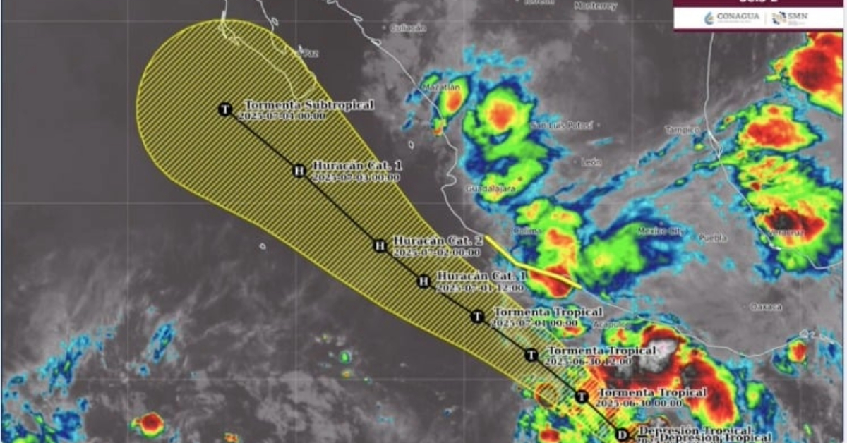
Tropical Storm Flossie is expected to become a Category 2 hurricane by July 2 as it moves parallel to Mexico’s Pacific coast, bringing dangerous rainfall, wind, and surf.
Tropical Storm Flossie is on the verge of forming from Tropical Depression Six-E and is forecast to strengthen rapidly into a hurricane as it parallels Mexico’s southwestern coastline early this week, according to NOAA and the National Meteorological Service (SMN).
The tropical depression was born from a low-pressure system on June 29 after days of atmospheric activity, including the absorption of a tropical wave and interaction with another. The storm system originally began organizing as early as June 19, the same day Hurricane Erick struck Oaxaca as a Category 3 hurricane.
Now, 10 days later, this sixth named cyclone of the season is gaining intensity and expected to escalate to Tropical Storm Flossie by Sunday night or early Monday morning. It is forecast to strengthen into a Category 1 hurricane by July 1 and reach Category 2 status just one day later.
At 4 p.m. local time Sunday, the system was located approximately 370 kilometers south-southwest of Punta Maldonado, Guerrero, and 410 kilometers south of Acapulco. It was moving west at 19 kilometers per hour (12 mph), with sustained winds of 55 km/h (34 mph) and gusts up to 75 km/h (46 mph).
Rainfall and Flooding Risk Across Southern Mexico
The storm is already bringing heavy rainfall to several Mexican states, including Guerrero, Oaxaca, Michoacán, Jalisco, and Colima. Forecasts indicate rainfall accumulations of 75 to 150 mm (3 to 6 inches) in Michoacán (northeast, east, and south), Guerrero (coast and north), and Oaxaca (north, center, and coast). Jalisco and Colima can expect rainfall between 50 to 75 mm (2 to 3 inches). Isolated rainfall totals could reach as high as 250 mm (10 inches) in mountainous terrain.
Authorities are warning that these rainfall levels may cause life-threatening flooding and mudslides, particularly in steep or mountainous regions.
Coastal Impact: Wind, Surf, and Watches in Effect
A Tropical Storm Watch has been issued for the southwestern coast of Mexico, stretching from Zihuatanejo, Guerrero, to Manzanillo, Colima. This means tropical storm conditions are possible in the region within the next 48 hours, particularly between Monday and Tuesday.
Strong gusts and tropical storm-force winds are expected to hit areas within the watch zone, posing risks to coastal communities, small vessels, and infrastructure.
Swells generated by the growing storm are forecast to build along Mexico’s southwestern coast starting Monday and continuing into mid-week. These waves will create dangerous surf and rip current conditions, making coastal waters hazardous for swimmers and beachgoers.
Storm Tracking Parallel to the Coast
Although the system is forecast to move roughly parallel to the national coast rather than making direct landfall, its proximity to land still makes it a significant threat. The SMN continues to monitor the storm closely as it advances, and authorities are urging residents in the affected states to remain alert and prepared for worsening weather conditions.
Preparedness and Warnings
Residents along the Pacific coast from Zihuatanejo to Manzanillo should prepare now for the potential impacts of heavy rain, strong winds, and rough surf. Emergency services and civil protection agencies are expected to issue further guidance as the system progresses.
While no evacuations have been announced, localized flooding and road closures are likely, particularly in low-lying and mountainous regions. Travelers and local populations should monitor updates from SMN and NOAA and follow any advisories from municipal or state emergency agencies.
Stay Informed
For the latest weather alerts and emergency instructions, follow updates from the National Meteorological Service of Mexico (SMN) and NOAA’s National Hurricane Center.
Tropical Storm Flossie is expected to become a Category 2 hurricane by July 2 as it moves parallel to Mexico’s Pacific . . .

")


")
