SUMMARY OF WATCHES AND WARNINGS IN EFFECT:
A Hurricane Watch is in effect for…
* San Blas to Mazatlan (north of Puerto Vallarta)
A Tropical Storm Warning is in effect for…
* Playa Perula to San Blas (This is the area of Puerto Vallarta, Mexico)
A Tropical Storm Watch is in effect for…
* North of Mazatlan to Bahia Tempehuaya
A Hurricane Watch means that hurricane conditions are possible within the watch area. A watch is typically issued 48 hours before the anticipated first occurrence of tropical-storm-force winds, conditions that make outside preparations difficult or dangerous.
A Tropical Storm Warning means that tropical storm conditions are expected somewhere within the warning area within 36 hours. (Puerto Vallarta)
A Tropical Storm Watch means that tropical storm conditions are possible within the watch area, generally within 48 hours.
Interests elsewhere along the coasts of west-central and southwestern mainland Mexico should monitor the progress of Willa.
For storm information specific to your area, please monitor products issued by your national meteorological service.
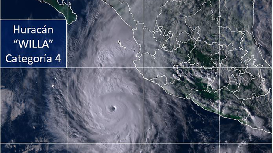
Hurricane Willa, headed for Mexico, strengthens to Category 4
DISCUSSION AND OUTLOOK
———————-
At 600 PM MDT (0000 UTC), the eye of Hurricane Willa was located near latitude 17.4 North, longitude 107.1 West. Willa is moving toward the north-northwest near 6 mph (9 km/h). A turn toward the north is expected later tonight and Monday. Willa is expected to accelerate toward the north-northeast and move over or very near the Islas Marias on Tuesday and approach the southwestern coast of mainland Mexico in the hurricane watch area by Tuesday night.
Satellite data indicate that the maximum sustained winds have increased to near 140 mph (220 km/h) with higher gusts. Willa is an extremely dangerous category 4 hurricane on the Saffir-Simpson Hurricane Wind Scale. Additional strengthening is expected during the next day or so, and Willa is forecast to be a dangerous
hurricane when it reaches the coast of Mexico.
Hurricane-force winds extend outward up to 25 miles (35 km) from the center and tropical-storm-force winds extend outward up to 80 miles (130 km).
The estimated minimum central pressure is 946 mb (27.93 inches).
HAZARDS AFFECTING LAND
———————-
STORM SURGE: A dangerous storm surge accompanied by large and destructive waves is possible along portions of the coast of southwestern Mexico by Tuesday or Tuesday night.
WIND: Hurricane conditions are possible within the hurricane watch area by late Tuesday, with tropical storm conditions possible by Tuesday morning. Tropical storm conditions are expected within the tropical storm warning area by Monday night or early Tuesday. Tropical storm conditions are possible within the tropical storm
watch area by Tuesday.
RAINFALL: Willa is expected to produce storm total rainfall accumulations of 5 to 10 inches, with local amounts to 15 inches, across portions of western Jalisco, western Nayarit, and southern Sinaloa in Mexico. This rainfall would cause life-threatening flash flooding and landslides.
Farther inland, Willa is expected to produce rainfall amount of 2 to 4 inches across portions of Zacateca, Durango, southeast Chihuahua, and Coahuila in Mexico, with local amounts to 6 inches possible. This rainfall could also cause life-threatening flash flooding.
SURF: Large swells generated by Willa are beginning to affect portions of the coast of southwestern and west-central Mexico. These swells are likely to cause life-threatening surf and rip current conditions. Please consult products from your local weather office.
SUMMARY OF WATCHES AND WARNINGS IN EFFECT:
A Hurricane Watch is in effect for...
* San Blas to Mazatlan (north of Puerto Vallarta)
A Tropical Storm . . .


