Hurricane Erick rapidly intensified off Mexico’s Pacific coast, becoming the second hurricane of the 2025 season and threatening southwestern Mexico with dangerous wind, rain, and storm surge.
This story is available in Spanish: El huracán Erick se fortalece rápidamente y amenaza la costa suroeste de México
The 2025 eastern Pacific hurricane season continues to surge ahead of schedule with the formation of Hurricane Erick, which rapidly intensified off Mexico’s coast this week. In less than 24 hours after forming as a tropical storm early Tuesday, Erick strengthened into the second hurricane of the season—and it’s now on track to become the most powerful tropical cyclone in the Northern and Western Hemispheres this year.
This marks an exceptionally early milestone: Erick is the fifth named storm of the season, forming earlier than any fifth storm since 1956. Historically, the fifth named system in the eastern Pacific doesn’t arrive until around July 23.
Satellite images from Wednesday, June 18, reveal Erick churning southwest of Mexico, already exhibiting signs of strengthening with organized clusters of thunderstorms. Another pocket of unstable weather over the southwest Gulf remains under watch but shows no immediate signs of development.
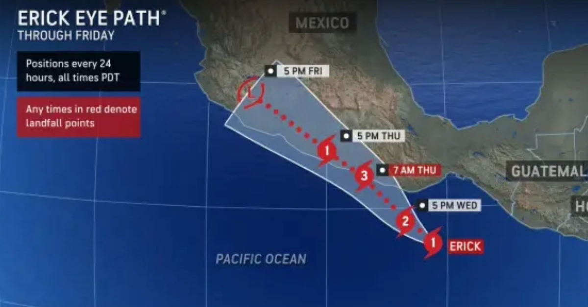
According to AccuWeather meteorologists, Hurricane Erick is expected to continue gaining strength over the next few days and may rapidly intensify into a powerful Category 3 hurricane. The storm is forecast to track northwest, potentially approaching the coast of Guerrero state—possibly passing near or even over Acapulco.
“We believe Erick will rapidly strengthen into a powerful Category 3 hurricane prior to nearing the Mexican coast,” said Alex DaSilva, AccuWeather’s Lead Hurricane Expert. “Erick may track very close to Acapulco with the full impacts you would expect from a hurricane—ranging from powerful wind gusts and power outages to torrential rain and flash flooding as well as storm surge flooding.”
The AccuWeather RealImpact™ Scale for Hurricanes currently ranks Erick as a Level 3 storm, based on a combination of forecasted intensity, geographic impact, and population exposure. That score could rise if Erick strengthens more than expected or takes a more direct path toward landfall.
The fast-developing hurricane follows closely on the heels of Tropical Storm Dalila and Hurricane Barbara. Barbara briefly reached Category 1 status on June 8 with maximum sustained winds of 75 mph but remained well offshore. Erick, by contrast, poses a far greater threat to populated coastal areas.
Rainbands from Erick are already expected to bring tropical downpours and gusty winds to parts of southern and southwestern Mexico before the storm’s center nears the coastline. Residents in Guerrero, Oaxaca, and Michoacán should prepare for hazardous conditions by the end of the week.
Officials warn of dangerous flash flooding and mudslides across coastal and mountainous terrain, as well as coastal hazards such as large swells, storm surge, and dangerous rip currents.
With two hurricanes already on the books, the 2025 season is running significantly ahead of the historical average. Typically, the first hurricane of the year doesn’t form until around June 26, and the second—especially a major Category 3 storm—emerges closer to mid-July.
This accelerated pace may be a sign of things to come. AccuWeather’s seasonal forecast calls for 14 to 18 tropical storms in the eastern Pacific this year, with seven to 10 becoming hurricanes. Up to six storms could bring direct impacts to Mexico or Central America.
And Erick may not be the last system this month. Meteorologists are closely monitoring another area of potential development west of Central America between June 24 and 27. If conditions align, this could become the sixth named storm of the season—further pushing 2025 into record-breaking territory.
Meanwhile, across the Atlantic, the hurricane season remains sluggish. Dry air, Saharan dust, and disruptive wind shear are limiting tropical activity in that basin. Though showers and storms have popped up near the southwestern Gulf and western Caribbean, none have shown signs of organizing.
“While the chances have become very small, we continue to watch the area close in to land in the southwestern Gulf and the western Caribbean for tropical development late in June,” DaSilva added. “Any system that forms there would likely have a very short lifespan due to limited time over warm water.”
With Erick gathering strength and heading toward Mexico, residents in vulnerable areas should prepare now. Emergency supplies, evacuation plans, and storm readiness measures should be reviewed as meteorologists continue to monitor the hurricane’s exact path and strength in the coming days.
Stay tuned for updates from local authorities and weather services, and consider enabling storm alerts via the AccuWeather app or your local weather provider.
Hurricane Erick rapidly intensified off Mexico’s Pacific coast, becoming the second hurricane of the 2025 season and threatening southwestern Mexico with dangerous . . .


