PUERTO VALLARTA (PVDN) – Hurricane Lidia, a menacing Category 4 storm, made landfall near the coastal community of Las Penitas, 120 km (75 miles) south of Puerto Vallarta, at approximately 5:50 PM MDT (2350 UTC) on Tuesday. According to the latest satellite imagery, The hurricane brought maximum sustained winds estimated at 140 mph (220 km/h).
Current Position and Trajectory
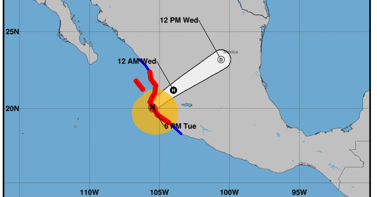
As of 6:00 PM MDT (0000 UTC), the hurricane was located near latitude 20.1 North and longitude 105.5 West. It is moving east-northeast at a speed of roughly 16 mph (26 km/h), with forecasts indicating a slightly faster east-northeastward motion through tonight. According to current projections, the eye of the storm will continue to move inland over west-central Mexico tonight and into Wednesday morning. The estimated minimum central pressure of the hurricane is 942 mb (27.82 inches).
Wind Speed and Extensions
Lidia is a Category 4 hurricane on the Saffir-Simpson Hurricane Wind Scale, with winds near the eye extending outward up to 30 miles (45 km) and tropical-storm-force winds reaching up to 140 miles (220 km) from the center. The system is expected to undergo rapid weakening as it moves further inland, although its effects will continue to be felt across a wide swath of west-central Mexico.
Hazards Affecting Land
Rainfall
The storm is anticipated to yield substantial rainfall, with totals ranging from 4 to 8 inches and localized maxima reaching up to 12 inches. These rainfall levels are expected across the state of Nayarit, southern parts of the state of Sinaloa, and coastal regions of Jalisco. This level of precipitation poses a significant risk of flash flooding and urban flooding, as well as the potential for mudslides in elevated terrains near the coast.
Storm Surge and Surf
A hazardous storm surge is expected to bring about considerable coastal flooding near and to the south of where Lidia made landfall. This surge will be accompanied by large and destructive waves. Swells generated by the hurricane will also affect the west coast of Mexico and the Baja California peninsula for at least another day, likely causing life-threatening surf and rip current conditions.
Wind
Hurricane conditions are presently affecting portions of west-central Mexico within the hurricane warning zone, with tropical storm conditions occurring in the areas under a tropical storm warning.
For additional details and key messages related to Hurricane Lidia, please refer to the Tropical Cyclone Discussion under AWIPS header MIATCDEP5 and WMO header WTPZ45 KNHC, or visit the official website at hurricanes.gov/text/MIATCDEP5.shtml.
Residents in the affected areas are advised to take all necessary precautions and to stay updated by consulting local weather services.
PUERTO VALLARTA (PVDN) - Hurricane Lidia, a menacing Category 4 storm, made landfall near the coastal community of Las Penitas, 120 km (75 miles) south . . .


