Puerto Vallarta, Mexico — The National Oceanic and Atmospheric Administration (NOAA) Weather Services Warns of Intensifying Storm Conditions
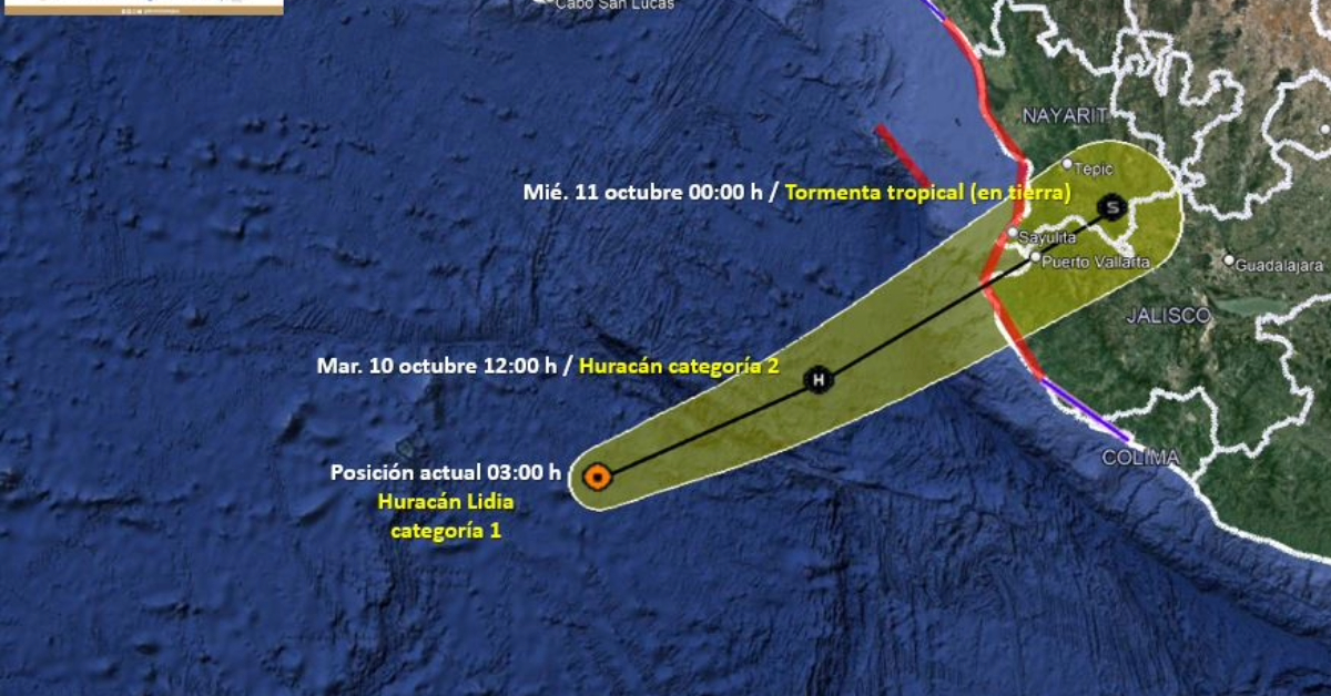
According to the latest data from NOAA Weather Services at 9:00 AM local time, Hurricane Lidia is intensifying as it approaches west-central Mexico. Advanced microwave imagery taken a few hours ago indicates the formation of a well-defined inner core with a nearly closed eyewall. Despite the absence of a visible eye in geostationary satellite images, the central dense overcast has shown more symmetry over the last few hours. Based on Dvorak estimates ranging from 77 to 90 knots, the hurricane’s initial intensity is now upgraded to 85 knots, classifying Lidia as a Category 2 hurricane.
Air Force Hurricane Hunters to Investigate
The United States Air Force Hurricane Hunters are en route to conduct a detailed investigation of Lidia this afternoon. This mission is expected to provide more accurate data on the hurricane’s current intensity. Meanwhile, the outer rain bands of the storm are nearing Isla Las Marias and other parts of west-central Mexico, with conditions projected to deteriorate through the course of the day.
Trajectory and Timing
Lidia is moving at an accelerated pace towards the east-northeast, with its latest recorded initial motion at 070/13 knots. Influenced by a mid- to upper-level trough situated to the west, the storm is expected to make landfall in west-central Mexico this evening. Notably, severe weather conditions are anticipated well ahead of the storm’s center, primarily affecting regions to the east.
Key Messages for Public Safety
- Strengthening Expected: Lidia is expected to continue to strengthen as it nears west-central Mexico today. Communities within the Hurricane Warning area are advised to prepare for dangerous hurricane-force winds beginning this afternoon.
- Flood Risks: The heavy rainfall associated with Lidia is likely to result in flash and urban flooding, along with potential mudslides in areas of higher terrain. This includes the state of Nayarit, southern parts of the state of Sinaloa, and coastal regions of the state of Jalisco in western Mexico.
- Storm Surge Alert: A hazardous storm surge is expected near and to the south of where the center of Lidia is projected to make landfall along the coast of west-central Mexico.
- Surf and Rip Current Warnings: Swells generated by Lidia will cause perilous surf and rip current conditions along the west coast of Mexico and the Baja California peninsula in the coming days.
Based on current forecasts, the Mexican government has extended the scope of Hurricane and Tropical Storm Warnings to include additional southern regions.
Further Developments
Further strengthening is expected due to very warm sea surface temperatures near 30°C and a favorable upper-level wind pattern. Lidia will likely be near major hurricane strength when it reaches the coast. Rapid weakening is expected once the hurricane moves inland, with forecasts predicting its dissipation by late Wednesday over the rugged terrain of central Mexico.
For real-time updates and safety information, residents are urged to stay informed through official channels.
Puerto Vallarta, Mexico — The National Oceanic and Atmospheric Administration (NOAA) Weather Services Warns of Intensifying Storm Conditions
According to the latest data from NOAA . . .


