Meteorologists warn of a 90% chance a new tropical cyclone will form midweek off Mexico’s Pacific coast, as Dalila weakens and rains persist across southern Mexico.
As Tropical Storm Dalila moves farther out to sea and becomes post-tropical, meteorologists are turning their attention to a new disturbance brewing off Mexico’s Pacific coast, which is highly likely to become the fifth named cyclone of the 2025 season.
Meteorologist Víctor Manuel Cornejo López reports that tropical wave number 3 is currently being absorbed by a nearby low-pressure zone, forming a tropical disturbance that has the potential to intensify into a tropical cyclone within days.
“Dalila is now history,” Cornejo López said. “It has weakened and is gradually moving away from the continent. It did, however, shift closer to the coast than expected and caused a significant rain event last weekend.”
Despite Dalila’s offshore turn near Manzanillo, the storm left its mark. Torrential rains were recorded in multiple parts of western Mexico, including:
- Versalles: 48 mm
- San Sebastián del Oeste: 43 mm
- Mayto: 46 mm
- El Tuito: 34 mm
- Ixtapa: 38 mm
These figures, measured in millimeters per square meter, indicate a notably wet episode for the region, especially in areas already vulnerable to flash flooding and infrastructure stress during storm events.
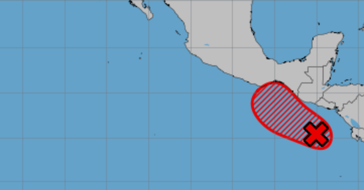
The U.S. National Hurricane Center (NHC) currently gives the new disturbance a 90% chance of cyclonic development. Forecast models, including Windy, suggest that the system could form as early as Wednesday or Thursday, hugging Mexico’s Pacific coastline.
This timing makes the system likely to become the fifth tropical cyclone of the Eastern Pacific hurricane season. If named, it would continue the 2025 season’s trend of early and aggressive storm development.
The formation zone is expected to remain very close to Mexico's southern coastline, increasing concern for coastal states such as Jalisco, Colima, Guerrero, and Oaxaca. These regions should remain on alert for increased rainfall, rising tides, and potential flash floods.
In the meantime, cloudy skies and intermittent rain continue across the southern half of the country, with scattered showers predicted in and around Puerto Vallarta and the Banderas Bay area. Local residents and tourists are advised to monitor updates from civil protection authorities and remain prepared for rapidly changing weather conditions.
The latest pattern of storm development highlights how quickly atmospheric systems can evolve during the peak months of the hurricane season. As with Dalila, not all storms will make landfall, but their indirect effects—particularly heavy rains and flooding—can still pose significant hazards.
For now, meteorologists and disaster response teams are closely tracking this developing system. Should it reach tropical storm strength, it would warrant active warnings and advisories along Mexico’s Pacific seaboard.
More updates will follow as the system develops.