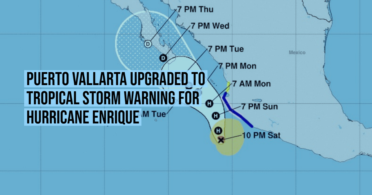
The government of Mexico has extended the Tropical Storm Warning northward to Punta Mita, moving Puerto Vallarta from a tropical storm watch to a warning. A Tropical Storm Warning means that tropical storm conditions are expected somewhere within the warning area.
At 1000 PM CDT (0300 UTC), the center of Hurricane Enrique was located off the northern coast of Guerrero, Mexico. Enrique is moving toward the northwest near 5 mph (7 km/h). A turn to the north-northwest is expected later tonight with the storm maintaining a northwest to north-northwest heading during next couple of days. On the forecast track, the center of Enrique is expected to pass near or just offshore of Jalisco late Sunday through Monday.
Maximum sustained winds remain near 85 mph (140 km/h) with higher gusts. Some slight strengthening is possible tonight or early Sunday, but Enrique is expected to begin to gradually weaken early next week as it moves over cooler waters.
Hurricane-force winds extend outward up to 25 miles (35 km) from the center and tropical-storm-force winds extend outward up to 140 miles (220 km).
Tropical storm conditions are occurring in portions of the warning area and will continue to spread northwestward within the warning area through Sunday night. Hurricane conditions are possible by Sunday night in the Hurricane Watch area, including in Puerto Vallarta. Tropical storm conditions are possible in the Tropical Storm Watch area Sunday and Monday.
By Monday, Enrique is expected to produce total rain accumulations of 6 to 12 inches with isolated maximum amounts of 18 inches over Colima and coastal sections of Michoacan and Jalisco in southwest Mexico. These amounts would likely produce life-threatening flash flooding and mudslides over portions of southwestern Mexico.
Swells generated by Enrique will affect the southwestern coast of Mexico during the next few days. These swells are likely to cause life-threatening surf and rip current conditions.