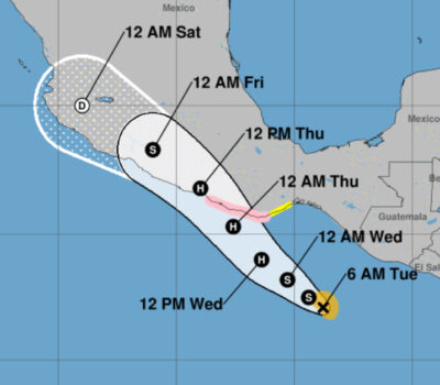
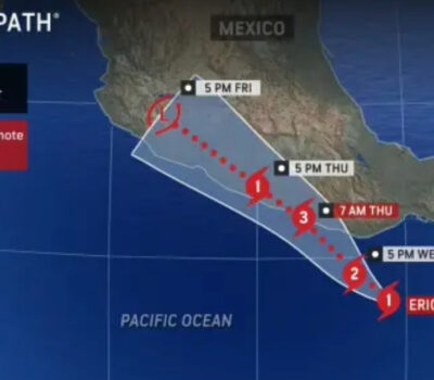
Puerto Vallarta faces a rainy and muggy Wednesday, June 18, 2025, while much of Mexico braces for heavy rains, heatwaves, and impacts from Hurricane Erika.
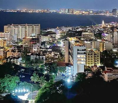
Puerto Vallarta will see a rainy and humid Wednesday, June 18, 2025, with light to moderate rain expected throughout the day. Local residents and tourists should prepare for wet conditions and a muggy atmosphere, with the weather offering little reprieve from the heat.
Morning
Starting early in the day, the city will experience a 100% chance of light to moderate rain. Winds from the northwest will be mild at around 9 km/h (5.6 mph). The temperature will reach 29°C (85°F), contributing to a sticky and uncomfortable environment. Locals are advised to stay in well-ventilated, shaded areas and avoid outdoor activity if possible.
Afternoon
The afternoon brings continued rain, with a 68% chance of precipitation and a steady temperature of 29°C. Although wind speeds will increase slightly to 11 km/h, there will be no significant gusts. The muggy air may make it feel warmer than it actually is. It’s another good reason to seek relief indoors in air-conditioned spaces or shaded patios.
Evening and Night
Conditions will remain wet into the evening, with an 87% chance of light to moderate rain. Temperatures will drop slightly to 26°C (80°F), but the air will still feel heavy. Umbrellas and ponchos are highly recommended for anyone heading out. Nighttime humidity may lead to discomfort indoors without proper ventilation or cooling.
Tip of the Day:
To stay productive during this damp weather, keep your workspace clean, cool, and well-lit. Poor lighting and high humidity can reduce concentration and affect performance.
Looking Ahead to Thursday, June 19
Thursday offers more of the same, with westerly winds barely noticeable at 5 km/h in the early morning and a 100% chance of light to moderate rain throughout the day. By late morning, temperatures will rise to 31°C (88°F), maintaining the muggy conditions. Nighttime temperatures will again settle around 26°C, with a continued 100% chance of rain. Expect consistent discomfort from heat and humidity if staying outdoors for long periods.
Nationwide Forecast for Mexico
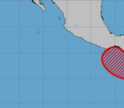
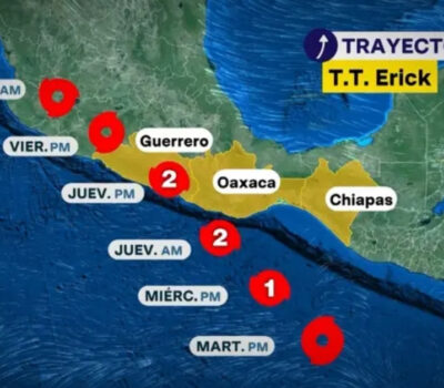
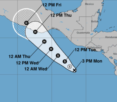
Mexico faces widespread and varied weather conditions on Wednesday, June 18, 2025, with several regions under threat from torrential rain, high winds, and dangerous heat due to the influence of Category 1 Hurricane Erika currently off the coast of Oaxaca.
Severe Weather Alerts
The National Meteorological Service warns of torrential rains (150–250 mm) in Guerrero, Oaxaca, and Chiapas. These storms may result in landslides, flooding, and rising river levels. Intense rainfall (75–150 mm) is expected in Michoacán, State of Mexico, Puebla, Veracruz, and Tabasco. Jalisco, Colima, Mexico City, Hidalgo, Morelos, and Tlaxcala will experience very heavy rain.
At sea, wave heights could reach 6 meters on the coasts of Oaxaca and Guerrero, while winds may gust up to 150 km/h. The Chiapas coast will also be affected by high waves and gusts of 70–90 km/h.
Heavy Rain Across Regions
A low-pressure system interacting with tropical wave number 4 is expected to drench much of southeastern Mexico, including Tabasco and Veracruz. Rain will extend into the Yucatan Peninsula with heavy precipitation in Campeche, Yucatán, and Quintana Roo. In the northwest, west, and center of Mexico, humid air from both the Pacific and Gulf will mix with unstable atmospheric conditions to bring further intense rain to Puebla, Michoacán, and the State of Mexico.
Isolated to moderate rain is expected in parts of Sonora, Coahuila, Chihuahua, Zacatecas, and Nuevo León.
Heatwave and Temperature Extremes
While the south battles rain, northern Mexico faces oppressive heat. Temperatures above 45°C are forecast in Baja California, Sonora, Sinaloa, and Chihuahua. The heat wave extends into Durango and the northern portions of several other states, with temperatures ranging from 35°C to over 40°C in many inland and coastal areas.
Maximum Temperatures June 18
- Over 45°C: Baja California, Sonora, Sinaloa (north), Chihuahua
- 40–45°C: Coahuila, Nuevo León (northwest), Durango (west), Campeche
- 35–40°C: Baja California Sur, Zacatecas, Nayarit, Jalisco, Colima, Michoacán, Guerrero, Chiapas (northeast), Tamaulipas, Tabasco, Yucatán, Quintana Roo
Wind and Wave Conditions
- Winds of 100–120 km/h with gusts up to 150 km/h on Oaxaca and Guerrero coasts
- Winds of 40–90 km/h on Chiapas coast
- Winds of 30–70 km/h in Campeche, Yucatán, and Quintana Roo
- Dust storms possible in Tamaulipas, Nuevo León, Coahuila, Chihuahua, and other north-central states
- Waves of 5.0–6.0 meters on Oaxaca and Guerrero coasts
- Waves of 4.0–5.0 meters on Chiapas coast
- Waves of 1.5–2.5 meters in Jalisco, Colima, and Michoacán
Regional Highlights
- Valley of Mexico: Cloudy with downpours throughout the day. Heavy rain in CDMX and intense rain in State of Mexico could trigger floods and landslides. Max temperatures 19–21°C in Mexico City.
- Baja California Peninsula: Partly cloudy with no rain. Heatwave continues in the north. Max temperatures over 45°C in northeast Baja.
- Central Pacific: Expect very heavy rain in Jalisco and Colima; heavy rain in Michoacán and Nayarit. Fog and high humidity will affect morning conditions.
- South Pacific: Torrential rains in Guerrero, Oaxaca, and Chiapas with potential for flooding, mudslides, and hazardous travel.
- Gulf of Mexico: Heavy rain in Tabasco, Veracruz, and Tamaulipas. Afternoon thunderstorms could bring hail and hazardous driving conditions.
- Yucatán Peninsula: Heavy rain and thunderstorms across Campeche, Yucatán, and Quintana Roo. Hot weather continues, especially in coastal regions.
- Northern Tablelands: Hot weather with scattered showers and thunderstorms. Heatwave persists in parts of Chihuahua and Durango.
- Central Tablelands: Intense rainfall in Puebla, with very heavy rain in Hidalgo, Morelos, and Tlaxcala. Afternoon thunderstorms expected.
Travel & Safety Advisory
Travelers are urged to monitor local advisories, particularly in areas affected by Hurricane Erika. Heavy rainfall and strong winds may result in flash flooding, road closures, and delays. Residents in at-risk areas should stay indoors where possible and secure outdoor items that may become projectiles in strong wind.
For continued updates on Hurricane Erika and national alerts, visit Mexico’s National Meteorological Service:
👉 https://smn.conagua.gob.mx/es/pronosticos/avisos/aviso-de-ciclon-tropical-en-el-oceano-pacifico
Puerto Vallarta faces a rainy and muggy Wednesday, June 18, 2025, while much of Mexico braces for heavy rains, heatwaves, and impacts . . .


