Hurricane Erick intensifies into a Category 3 storm with 195 km/h winds as it nears landfall on the Guerrero and Oaxaca border. Authorities issue alerts and safety guidelines.
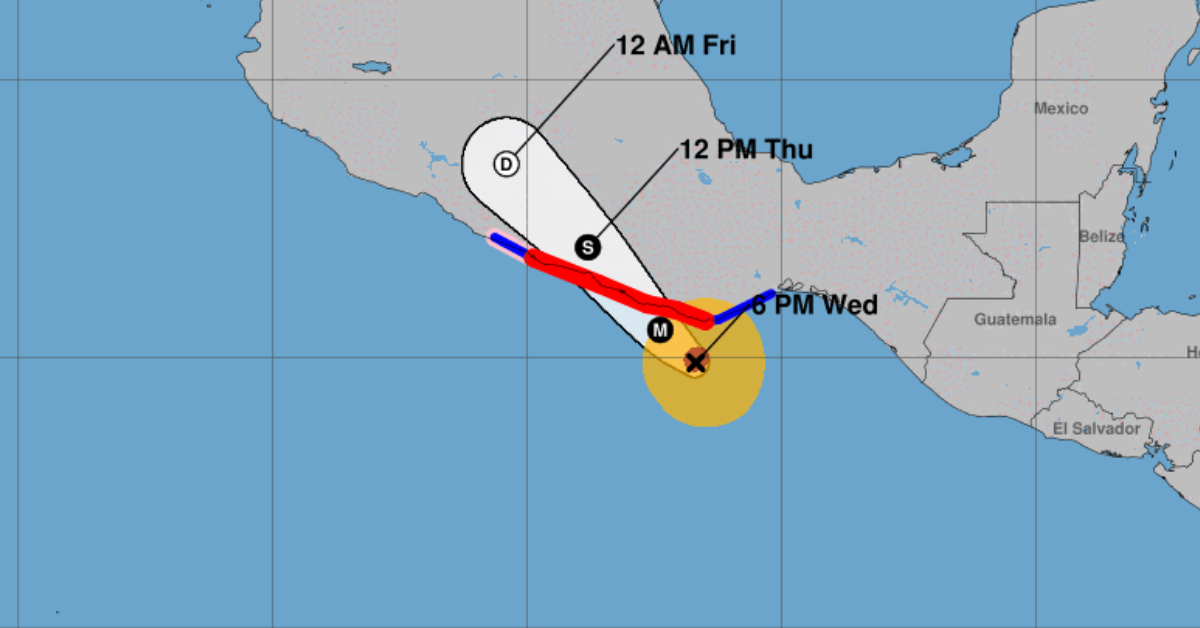
Hurricane Erick sharpened overnight and now packs sustained winds of 195 km/h (120 mph) as it carves its path toward the border of Guerrero and Oaxaca. Meteorologists say the storm’s eye is forming at its center, a sign it could strengthen further before it hits land early Thursday.
Erick moves northwest at 15 km/h. Forecasts show it may surge to Category 4 strength before landfall. Officials urge coastal communities to finish all evacuation plans and storm preparations by this afternoon.
Storm at a Glance
- Current intensity: Category 3 with maximum sustained winds of 195 km/h
- Motion: Northwest at 15 km/h
- Potential: Possible upgrade to Category 4 before landfall
- Landfall window: Early Thursday on the Guerrero–Oaxaca border
Alert and Warning Zones
Hurricane effects (Hurricane Warning): Stretching from Puerto Ángel, Oaxaca, to Acapulco, Guerrero.
Tropical storm effects (Tropical Storm Warning): From Puerto Ángel to Salina Cruz, Oaxaca, and from Acapulco to Tecpan, Guerrero.
Simultaneous hurricane warning: From Acapulco to Tecpan, Guerrero.
Authorities keep these zones active as Erick approaches. Communities inside the red and purple zones should expect powerful gusts, dangerous storm surge, and flooding. Those in blue zones face heavy rains and strong winds.
Recommended Actions for Residents
1. Avoid riverbeds and low-lying areas.
Flooding or sudden overflow can turn dry riverbeds into dangerous torrents.
2. Identify a shelter.
If you live in a risk zone, locate a temporary shelter now. Call 911 or contact Civil Protection for shelter details.
3. Secure your home.
Repair or reinforce roofs, windows, and walls. Clean drains, gutters, and manholes to help water flow.
4. Trim trees and shrubs.
Weak branches can break off in high winds and damage property.
5. Anchor loose objects.
Bring in or firmly tie down items like antennas, signs, and hanging decorations.
6. Pack an emergency kit.
Include water, nonperishable food, flashlights, batteries, first-aid supplies, and a portable radio.
7. Protect important documents.
Keep IDs, insurance papers, and medical records in a waterproof bag or scan them to a USB drive or email.
What to Expect When Erick Makes Landfall
Residents can anticipate extreme winds, coastal flooding from storm surge, and heavy to torrential rains inland. The risk of rivers and streams overflowing remains high. Sea waves will reach dangerous heights along the coast.
Emergency teams stand ready to assist after the storm passes. Power outages and road blockages could last days in isolated areas. Local authorities will provide updates on shelter openings and aid distribution.
As Hurricane Erick grows stronger, clear and calm planning will help families stay safe. Finish all last-minute preparations this afternoon, and follow official instructions as the cyclone moves in.
Hurricane Erick intensifies into a Category 3 storm with 195 km/h winds as it nears landfall on the Guerrero and Oaxaca . . .


