Potential Tropical Cyclone Five may strengthen into a hurricane before making landfall in southern Mexico, bringing dangerous winds, heavy rains, and life-threatening flooding.
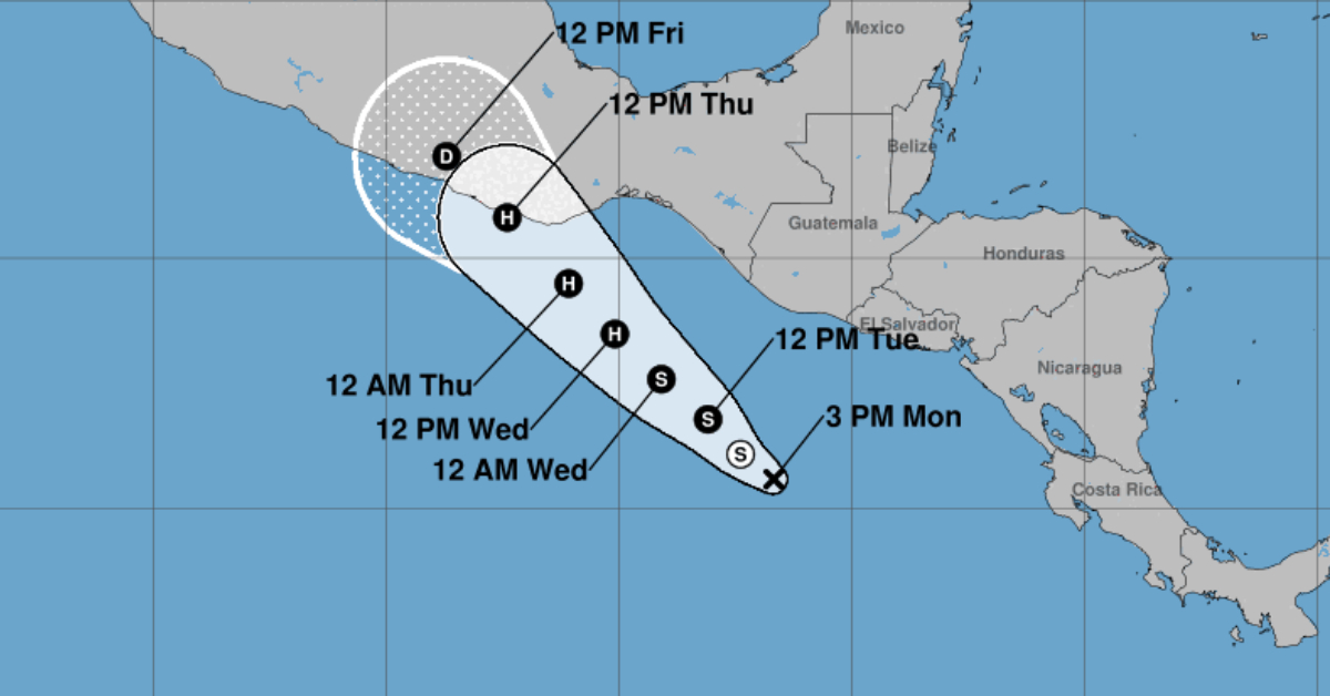
Potential Tropical Cyclone Five is gaining strength and organization off the Pacific coast of Guatemala and is forecast to become a hurricane as it approaches southern Mexico by Wednesday or Thursday, according to the National Hurricane Center (NHC).
Located a couple hundred miles south of the Guatemalan coast, the broad area of low pressure has seen a noticeable uptick in thunderstorm activity over the past 48 hours. Satellite data shows a disorganized but intensifying system, with sustained winds currently estimated at 35 mph (55 km/h) and a minimum central pressure of 1009 mb.
In response to its projected development and increasing threat to land, the NHC has initiated advisories for Potential Tropical Cyclone Five—a designation used when a system has not yet become a tropical cyclone but poses a significant risk of wind or storm surge impacts.
Path and Forecast
The disturbance is moving northwest at approximately 7 knots (13 km/h), guided by a high-pressure ridge over the southwestern Atlantic. This general direction is expected to continue for the next several days.
Forecast models differ on the speed of the storm’s progression. While the GFS model suggests slower movement, the ECMWF projects a faster track toward the Mexican coast. The NHC’s forecast blends both models and puts the system on a path toward southern Mexico by late Wednesday or early Thursday.
Environmental conditions remain highly favorable for rapid intensification. According to SHIPS model data, there’s a 50 percent chance the system could reach 55-knot winds (approximately 63 mph) within 48 hours. NHC officials predict the system will be named as a tropical storm by Tuesday and could reach hurricane strength shortly thereafter.
Expected Hazards
Heavy Rainfall:
The storm is expected to drop significant rain across Central America and southern Mexico. Forecast totals include:
- 2 to 4 inches (5–10 cm), with localized maxima of 6 inches (15 cm), across parts of El Salvador, Guatemala, and the Mexican states of Chiapas, Tabasco, and Veracruz.
- 4 to 8 inches (10–20 cm), with isolated totals up to 12 inches (30 cm), are likely in Oaxaca and Guerrero.
The rainfall may trigger life-threatening flash floods and mudslides, especially in mountainous regions.
Winds and Hurricane Watches:
Winds near the center are currently at 35 mph, but rapid strengthening is expected. Hurricane watches are likely to be issued tonight or early Tuesday for portions of southern Mexico. If the storm continues to organize, residents could experience hurricane-force winds by late Wednesday or early Thursday.
Dangerous Surf:
Swells from the developing storm are forecast to reach the southern Mexican coastline within the next day or two. These conditions could produce life-threatening surf and rip currents, and coastal residents are advised to stay out of the water and heed local weather advisories.
NHC’s New Advisory Window
In a shift from prior policy, the NHC can now issue Potential Tropical Cyclone advisories up to 72 hours before tropical-storm-force winds are expected on land—an increase from the previous 48-hour window. This change is aimed at giving emergency managers and residents more time to prepare for tropical threats.
Watches and warnings for hurricanes or tropical storms will still be issued within the standard 48 and 36-hour windows ahead of anticipated landfall.
Stay Alert
With a high 90% chance of development in both the 48-hour and 7-day forecasts, Potential Tropical Cyclone Five is expected to become a named storm imminently. Given the possibility of rapid intensification and uncertainty regarding the exact landfall location, residents in southern Mexico—particularly in Oaxaca, Guerrero, Chiapas, and Veracruz—should prepare for the likelihood of a hurricane and closely monitor updates from local authorities and the NHC.
For official forecasts, rainfall graphics, and updates, visit hurricanes.gov.
Potential Tropical Cyclone Five may strengthen into a hurricane before making landfall in southern Mexico, bringing dangerous winds, heavy rains, and life . . .


