PUERTO VALLARTA (PVDN) – As Tropical Depression Two-E intensifies, the Mexican government has extended the Tropical Storm Warning northward to Manzanillo, while also issuing a Hurricane Watch from Lazaro Cardenas to Cabo Corrientes in the Southshore of Puerto Vallarta.
The Hurricane Watch is a critical alert, indicating that conditions favorable for a hurricane are expected within the next 48 hours. It is usually issued to allow sufficient time for necessary preparations, as conditions can become dangerous when tropical-storm-force winds begin.
Similarly, a Tropical Storm Warning has been issued for the coastal areas from Punta Maldonado to Manzanillo. This warning signifies an expected arrival of tropical storm conditions within the next 36 hours.
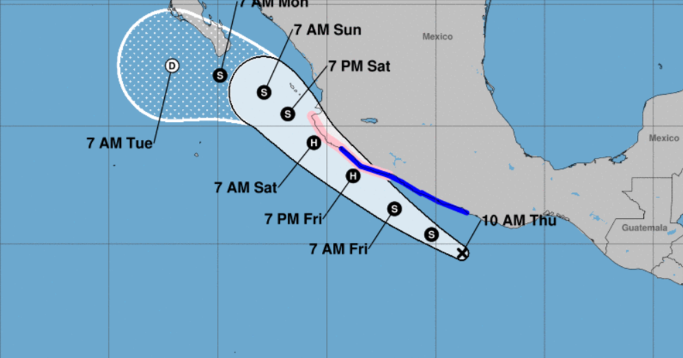
The unfolding situation calls for a keen watch by interests along the west-central coast of Mexico and in the southern part of the Baja California peninsula. Given the unpredictability of weather systems, additional warnings and watches may be required later today or on Friday.
As of 10:00 AM CDT, the center of Tropical Depression Two-E was located near latitude 14.6 North, longitude 98.8 West, moving west-northwest at approximately 13 mph. The same motion is predicted to continue until early Saturday, with a potential decrease in speed in the days to follow.
The system currently has sustained winds of about 35 mph, but forecasters anticipate strengthening. The depression is predicted to escalate to a tropical storm by later today, and possibly into a hurricane by Friday evening.
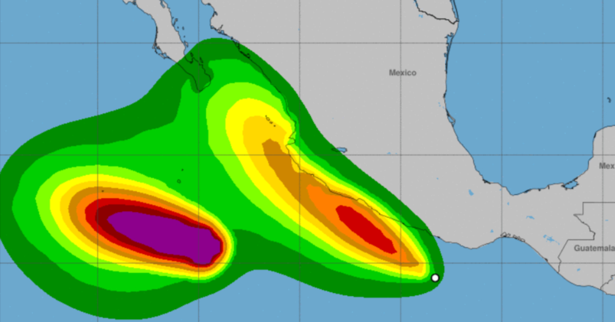
Expected storm total rainfall of 3 to 5 inches, with maximum amounts up to 7 inches, has raised the threat of localized flash flooding across southern Mexico, from Oaxaca to Jalisco, through Saturday.
Swells generated by the depression could result in life-threatening surf and rip current conditions along the southwestern coast of Mexico in the next couple of days.
Residents and visitors in the affected areas are strongly advised to monitor updates from their local weather offices and the national meteorological service, and to prepare for the potential impacts of this storm.
WIND: Hurricane conditions are possible within the hurricane watch area Friday and Saturday. Tropical storm conditions are expected in the tropical storm warning area beginning later today and continuing through Friday evening.
RAINFALL: Through Saturday, storm total rainfall of 3 to 5 inches, with maximum amounts of 7 inches, is expected across southern Mexico from Oaxaca west to Jalisco. This rainfall could lead to localized flash flooding.
SURF: Swells generated by the depression are forecast to build and spread northward along the southwestern coast of Mexico during the next couple of days. These swells are likely to cause life-threatening surf and rip current conditions. Please consult products from your local weather office.
PUERTO VALLARTA (PVDN) - As Tropical Depression Two-E intensifies, the Mexican government has extended the Tropical Storm Warning northward to Manzanillo, while also issuing . . .


